Pole Knoll Recreation Area, Apache-Sitgreaves National Forest, Arizona

I mentioned a couple weeks ago on my facebook page, that I had taken a day ride with family and friends in the Pole Knoll Recreation Area of the Apache-Sitgreaves National Forest, and that I would make a blog post with pictures soon. Sorry it took so long.

Pole Knoll is a designated USFS recreation area located on US 260 about 12 or so miles west of Eagar, Arizona. It is about two miles west of the turnoff to Greer. Coming east from Show Low on US 260, you would find it about 5 miles past the turnoff to Sunrise Ski Resort, about a quarter-mile after you come off the top meadows and re-enter the forest. The entrance is marked well and is on the south side of the highway.

Drive to the parking area

After turning off, you will drive about a quarter-mile on a paved road to the parking area. There is sufficient parking and turn-around space for even fairly large trailers. There are bathrooms, but I don’t recall any water, electric, or other services, besides picnic tables. There is a registry on a board, with the area regulations posted. Interestingly, the board indicates “No overnight camping”. However, I am certain that refers specifically to the area immediately surrounding the parking area, since camping is unregulated throughout the Apache-Sitgreaves National Forest.  It is neither a national or state park. There are no restrictions to stay on designated paths. They are there for convenience and so folks don’t get lost.

Registration and rules board with maps and brochures

There are marked trails leading away from the parking area, all of which eventually lead back into each other and return you to the parking area. There area USFS sign posts to tell you where the trails lead, with mileage.  I would love to be able to tell you how many miles each trail was, but since we didn’t stick with the trails, I can’t.  What I can tell you, is that no matter where you go in this area, it is a beautiful and pleasant ride.

We headed out on the Pole Knoll trail, which, if one actually follows it, leads up to the top of Pole Knoll. I expect the elevation at the top is near 9,500 feet, but since you are starting out at near 9,000, it’s not all that impressive, as mountains go, ergo the designation “knoll”. The trail to the knoll probably is no longer than four or five miles, and would make a comfortable morning or afternoon ride. The trail is not particularly challenging and is suitable for all levels of riders and horses. Although the elevation is high, if you have been in the area a day or two, both you and your horses will be fine for this ride.

Heading up the trail

Heading up the trail

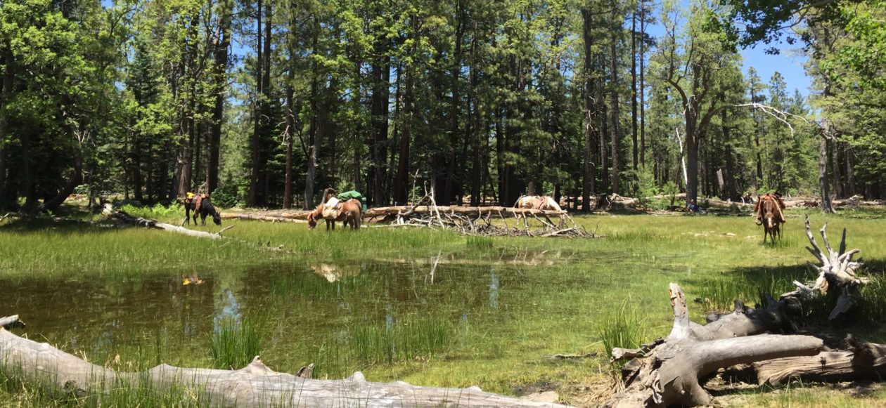
For our ride, we followed the lead of my sister and brother-in-law, Tina and Kelly LeSueur, who have spent some time riding in the area. About a mile from the parking area, we came to  a fork in the trail.  We took the left fork, which passes around the base of Pole Knoll (the right fork leads to the summit). After a short half-mile or so, we came out into a large meadow.  At this point Tina and Kelly left us and headed back to their trailer, as they had an afternoon appointment in town. Dad, my friend Sterling and his son, and I continued our ride.

2013-05-15 11.07.25We left the designated trail and headed out across the meadow to see what there was to see. We went into the forest on the other side of the meadow and entered an area that must have been one of the last areas left open to logging in the national forest. The area was open, with nice, large trees, and little scrub brush, a good, healthy forest. A little farther along, we entered an area that was the result of many years of poor forest management where the forest was overgrown, with scrawny trees growing so close you couldn’t pass through on a horse. The difference between the two areas is stark. I much prefer riding through the more open areas that were thinned by logging many years ago. There is much debate with regard to forest management and the current government prohibition against logging and thinning, but that’s for another post.

Dad on Honey the mule

As we passed through some of that area, Honey, the mule my dad was riding, stepped on something that popped a stick up under her belly…so we think anyway…and she thought she was snake bit or something. She gave a couple nice bucks, which unseated Dad, then a quick turn to the right, and off he went! Luckily, Dad landed in about the only soft spot in the area, and suffered only a bruised backside. Old Honey stopped only a few steps away and looked pretty embarrassed and concerned. She stood quietly while Dad got back on. We finished the ride with no further excitement. Dad turned 79 this month. I hope I can handle getting bucked off when I’m his age.

Canyon of the Little Colorado

Another half-mile or so along, we came up to a canyon we believe is the canyon of the Little Colorado River. The drop-off was too steep to attempt a descent where we were, so we couldn’t tell for sure, but it offered some very nice views. We followed the rim back to the east and eventually came to a promontory that gave a nice view of Greer, Arizona. We stopped and took a few pictures.

Just as we were getting back underway, I spied a couple of wild turkeys roosted just about twenty feet off the trail. Amazingly they hadn’t seen or heard us, but were still sound asleep. I pointed at them to show Dad while I was groping to get my camera out and turned on. Dad never saw me point, but he saw the turkeys. He gave a loud whisper, “Tony! There’s some turkeys!” Well, that woke them up! That was all it took and off they went. Turned out there was a whole flock of them, probably ten or twelve in all, and off they all flew, gliding down the valley. I just grinned at Dad and said, “Oh, really?” We had a good chuckle over it. It’s good to have something to rib your dad about when you’re both out doing the thing you love best in the world.

Looking off toward Greer

As we rounded the hill we came upon an old logging trail and followed it down a ways to a nice grassy spot where we enjoyed our lunches and let the horses graze a bit. From that point we were back on a trail, more like a four-wheel-drive trail, but it appeared to lead off toward the east, whereas we needed to head back northwest to get back to the parking area. I suppose one could follow the old logging trails all the way to Greer and further if he wished, but our ride was just for the day. We cut cross-country heading back, just letting the horses have their head. Another mile or so along, we popped back out onto one of the designated trails and followed it back to the parking area. Our entire ride was a matter of about three hours, covering no more than five miles.

All in all, it was a very nice, relaxing trail ride. In this area one could go for hours or for days. There are trails leading up onto the plateau where the Big Lake Recreation Area is, as well as many other directions one might take. As I said before, riding and camping are unregulated in this area. Four-wheelers, bikes, and vehicles are allowed. There are no leash laws for your trail dogs either. I’ve never seen more than two cars in the parking area, and it’s likely you’ll be the only ones in the area. It’s just a great place to ride.

Wildlife you stand a good chance of seeing are elk, mule deer, pronghorn (American Antelope), turkey, coyote, and black bear. If you’re lucky, you might catch a glimpse of a mountain lion.

I hope you enjoyed the narrative and the pictures. Take a look at the area on Google Earth or Google Maps. You’ll see what I’m talking about. If you happen to be passing through the area, take a ride through the Pole Knoll Recreation Area.

Take care and keep riding.


Giving some new equipment a test drive…er…ride…

The rain let up this morning, and it was nice and cool here in Virginia, so I took the opportunity to go for a short trail ride around home and take along my new big Smith and Edwards saddle bags for a test drive…er ride.

My extra large Smith and Edwards saddle bags

As I wrote in a previous post, the bags are made of woven nylon, a material sometimes known as “Iron Cloth”. This stuff has a reputation for being as close to indestructible as you can get. I have friends who have pack paniers made of this stuff. They tell me a horse can’t hurt it, you can’t stain it, and you can wash anything that gets on it away with plain old water, including blood. I have always been partial to canvas and leather, but I have to admit, this stuff is tougher, lasts longer, and stays cleaner. The only drawback I can find, is that it looks sort of “space-age” sitting there behind my saddle. Then again, I’ll bet any old cowboy back in the day would give his eyeteeth for a set of paniers made of this stuff.

2013-05-24 12.03.00I was a little concerned about the size, which is 12 X 12 X 6″. They are shown as “Extra Large” on the tag. The largest canvas saddle bags I have seen offered were 12 X 14 X 4, but I didn’t care for the nylon straps and plastic buckles they had.  I find the flat-braid nylon straps some other saddle bags have are too limp and hard to work with from the saddle or with gloved hands. As for plastic buckles, I simply don’t like them. I’ve had some break on other kinds of camping gear (and they normally can’t be replaced) and I also find them difficult to handle with gloved hands. These Smith and Edwards bags have heavy bridle leather straps and steel buckles, which I prefer.

From the rear
From the rear

As you can see from the pictures, These saddle bags hang well from the saddle. They have heavy grommets for saddle strings to pass through and tie behind the cantle. You have the choice of a D-ring or a grommet lower down, where the cantle meets the seat jockey. Once these saddle bags are tied in place, they will stay. You won’t have a problem with them sagging off to one side, although, if they aren’t balanced, they could pull your saddle off to the side.

Some folks prefer the nylon or cordura saddle bag outfits that have everything compartmented in zippered pockets and bags. My personal preference is simple, old fashioned, saddle bags. I find that with the zippered pockets, I tend to stuff too much stuff in them. Then when I need something, like, say, a jacket or a slicker, I have to unzip then rummage and pull, until I end up pulling a bunch of other stuff out with the jacket and it ends up on the ground. With regular saddle bags, I fill my bags with things like first-aid kits, lunch, snacks, hoof boots, binoculars, cameras, and light stuff I might need to have to hand while riding. I always tie my slicker and jacket on behind the cantle, easy to reach in time of need by simply pulling the bow on my saddle strings.

I have, on one occasion, tied my bedroll on behind my cantle. I don’t like to do that, but on a simple overnighter without a pack horse, it can be done. I would recommend a light summer sleeping bag for that, though, due to size. I can see where one of the cordura zippered compartment outfits might be nice in that case, where you could stuff the sleeping bag into the cantle bag portion. My preference, however, is to put the bedroll on a pack animal, even for short two-three day trips.

All-in-all I think these Smith and Edwards saddle bags I bought are going to do the trick just right for our Mexico-to-Canada trip, and many other pack trips.

I have always used round canteens, but I'm going to try a mil surplus collapsible (right)
I have always used round canteens, but I’m going to try a mil surplus collapsible (right)

I was able to test out another piece of new gear I bought while I was in Arizona. I bought a military surplus two-quart water bladder. These new-style military canteens looked like they might do well hanging on the side of a saddle for a pack trip or just for a day ride. I have used, as a matter of preference and availability (that’s what I had at hand), the old style round canteens with the indian blanket sides and metal band around them to protect the plastic canteen. I have had a number of them crushed and broken by horses rubbing them against trees. I have learned never to leave my canteen hanging on the saddle while the horse is standing tied. The last one I had, I removed the steel band and the indian blanket and wrapped it in rawhide. It lasted for many years, but recently sprung a leak. So, I decided I’d try something new.

MIlitary surplus canteen on saddle

As you can see, the military surplus canteen hangs well on the side of my saddle. Dad and I have found that a canteen hangs best by hooking the strap around the cantle, such that one sits on the strap, as you see in the photo. This places the canteen behind the leg and out of the way. It rides well on the horse and doesn’t get in the way up front or bang on your knee while trotting or climbing ascents. This canteen has a thin, but strong nylon webbing strap that cannot be felt while seated on it. The strap is adjustable and can be fit to hang the canteen exactly where you want it. I found I liked to hang it with the mouth pointing back. When I had it pointing forward I occasionally felt it contact the back of my thigh.

The one surprise I got with this canteen, which shouldn’t have been a surprise at all, was when I took my first drink. This is a soft canteen, a plastic bladder, and you can’t hold it like a regular canteen while removing the top. It will simply spill water all over you. You have to sit it on your hand, supporting it from the bottom, while opening it and drinking from it, like you would a water bag. As you use water, the bag becomes thinner. When empty it can be stuffed in a saddle bag, out of the way. Pretty handy.

One other little handy option these canteens offer, is that some have a fitting for a water tube, like a cammelback, in the lid. If you would like to buy or order one of these, decide first whether a water tube is an option you want, then make sure the one you get has a lid with the fitting. I don’t intend to use a water tube, but the fitting doesn’t get in the way at all and has its own tab to keep it covered.


The carry bag is made of nylon, like most modern military surplus bags of any kind. Tough, light, handy. The bag has a small pocket with a velcro closure for purification tablets, which I though was a handy thing. I normally have to dig through my saddle bag to find my small bottle of tablets. The strap, as I mentioned, is nylon webbing. It is adjustable and has a snap on one end. On the back of the bag are the military-style belt hooks, for hanging the canteen on a military-style belt. These hooks work equally well for hanging the canteen on any type of belt or strap, provided it isn’t too thick. You can get the bags and straps in tan, olive drab, or either color of camouflage, to suit your taste.

I found the military surplus canteen, at $15.00, including the carry bag and strap, to be a good value. The one shown on the saddle was bought from a military surplus store in Pinetop, Arizona. I ordered the green one from an on-line store on ebay and paid $7.99, but with shipping came out only little less than the store-bought one.

So, two more pieces of gear added to my outfit.

I just received a set of “Modified Arches” for my first effort at building a Decker-style pack saddle from Mr. Bork at Bork Saddlery Hardware, along with several antique saddle horns he threw in. Stay tuned for more on them.

Raspberry Creek Trail, Apache-Sitgreaves National Forest, Arizona

I visited Utah and New Mexico last month for college graduations of two of my kids. I also spent some time in Arizona with my parents. While I was in Arizona, Dad and I took a ride part-way down Raspberry Creek Trail. I have selected this trail as part of our Great Western Trail ride, planned for 2015. I had heard the trail was burned-out and eroded so badly that it was impassable. I wanted to see how bad it was. I have attached several photos of the ride in this post, but you can see the full album in the WTR Gallery.

Turns out the trail, at least the upper part of it, has been maintained by a rancher who has a range lease in the area. The trail was in great shape. The Wallow Fire, that burned through the area three years ago, didn’t do as much damage as I had been lead to believe on this trail.

There were several places that were obviously affected, but it looked like spot-fire burns and most places were simply thinned-out by the fire, rather than scalped. There were areas visible from the trail that received much worse damage than the trail itself received.

Strayhorse Camp parking area

The trailhead is about 62 miles south of Eagar/Springerville, AZ and about 35 miles north of Morenci, on highway 191. Highway 191, in that area is closed during the winter, but opens as soon as the snow begins to recede. The elevation passes the 9,000 ft. mark around the Hannagan Meadow Lodge area up on top. Several great trails that lead down into the Blue Wilderness Area head there at Hannagan (Steeple Creek, Grant Creek, Foote Creek). A note of warning about Highway 191, is that it used to be designated Highway 666. The name was changed because folks felt 666 was inappropriate for a highway designation. If you think “Highway 666” is an inappropriate name for a highway, you haven’t driven this one. Rigs over 40′ are highly discouraged.

Looking out over southeastern AZ from US 191

It is a two-lane highway that winds its way down the Mogollon Rim and drops several thousand feet in a matter of a few miles. Check your brakes before you leave Hannagan if you are coming from the top.

Back to the trail. The trailhead is at a designated camp area called “Strayhorse”. It is about 2.5 miles below the “Blue Lookout” scenic vista point, and about one mile below the famous “Arrow Tree”.

The famous "Arrow Tree" on US 191
The famous “Arrow Tree” on US 191

The trailhead has camping areas (although camping is unregulated in this area), enough parking area for several stock trailers (remember, trailers longer than 40′ are highly discouraged), toilet facilities, and a small corral. No water service. On the west side of the highway you will find the trailhead for Strayhorse Trail, which leads to other trails, such as Eagle Creek (up which our GWT ride will come), Salt House Creek, Chitty Canyon, Rim Trail, and several others.  One can ride trails from Strayhorse all the way to Morenci, or on up to Alpine, and further. On the east side of the highway, is the Raspberry Creek Trailhead, which drops 9.5 miles to the Blue River, just south of the Blue Wilderness Area. I “guesstimate” the elevation at the trailhead to be around 8,000ft. By the time you reach the Blue River you will be at around 4,000ft. I haven’t checked those figures by map or GPS, but they are in the ballpark.

Pipe corrals (no water) at Strayhorse Camp parking area

From the Corral you head toward the restrooms and continue past them, and you’ll find the trail. At that point it looks like a two-track road, which it is.

Raspberry Creek Trailhead

Follow that for about a quarter mile, and you’ll come to the USFS sign for the trailhead. Just past that, you’ll see a small cabin and corrals with some livestock. That is the rancher’s headquarters for his range lease. If you see him, you might thank him for maintaining the trail. He has a bathtub water trough near the cabin, fed by a capped spring. I’m sure he wouldn’t mind folks watering there, but be courteous and conscientious of his ranch and livestock. There are some natural springs where you can also water your horses on the trail.

The young jack that fell in love with Honey the mule

As we passed the cabin, we noticed several horses, a mule, and a donkey hanging around the place. The donkey, a young jack, decided he was in love with Honey the mule, ridden by Dad, and fell in with us for the entire ride.

The trail was in excellent shape, with rocks placed to control runoff and erosion. The trail was well-planned and laid-out. As I mentioned, it drops close to 4,000ft in under 10 miles. There are switchbacks where needed and the the descents and climbs are reasonable. We crossed a number of runoff streams, that likely go dry most of the year, and passed several small springs along the trail. Not much grass to be had, but there is a little in certain areas you will pass. Not enough for daily feed for horses, so we plan to carry feed for our GWT trip as we pass through this area.

The trial is quite rocky. Shoes or boots recommended

The trail is quite rocky, so unless your horses are kept on similar ground and their hooves are toughened up, shoes, or at least boots, are recommended. Barefoot horses will be tender by the time they reach the bottom.

For this ride, our purpose was only to check out the upper part of the trail, which I had been told was damaged by the recent fires. We rode about three miles down the trail, then back to the trailhead. Even that was a nice ride. Our mounts were tired by the time we finished the climb out.

On our ride back to the trailhead, we encountered a pretty good-sized Timber Rattler. He was about four feet long and every bit of three inches in diameter. He was sunning himself on the trail. I heard the warning rattle and felt my horse tense up, so once I located the snake, I got off and lifted him off the trail with a good, long, stick. Rattlers aren’t all that aggressive, and normally only strike when they are severely bothered. I consider them to be quite considerate critters. At least they give a warning and let you know where they are, and give you a chance to avoid trouble.

A fairly large Timber Rattler on Raspberry Creek Trail

As for wildlife, you stand a good chance to see elk, mule deer, bear, desert bighorn sheep, mountain lions, coyotes, smaller varmints, and even Mexican Gray Wolves. We always carry a firearm when we ride the area, as much for protection from the lions and tigers…er wolves…and bears (oh my!), as for use in case a horse should go down. Our preference, not necessary. On a day ride, you’re not likely to have any problems, but if you decide to make it an over-nighter…well, you decide for yourself.

Weather was severe clear, as is common in Arizona. Protection from the sun is essential at this elevation. A wide-brim hat and neck scarf, and chapstick are recommended, as well as long-sleeved shirts. Carry at least a two-quart canteen. Always carry a jacket, even in the summer. If you should end up afoot overnight, you’ll be glad you have it. You’ll also need sun protection for your horses, if you have any with pink skin on their noses, ears, and eyes. Otherwise, they’ll definitely sunburn.

About as remote as you can get

This part of Arizona is extremely remote. You are not likely to meet anyone on the trail, on foot or mounted. There is no store or fuel facility for over 30 miles from the trailhead. The closest hospital is in Morenci, about 35 miles or so south of the trailhead on Hwy 191. Cell coverage is spotty, but isn’t reliable until you get back up on top, near Alpine, or farther down near Morenci. Dad got a text message while we were at the trailhead, though.  Just sayin’.  Keep these things in mind while planning your trip.

Going from the top down to the Blue, you will find it a relaxing and enjoyable ride. The descents aren’t particularly difficult ones, and, like I said before, the trail is well designed. The switchbacks are well laid out. The portion of the trail we rode was well maintained and in excellent shape. This  trail would be appropriate for riders and horses with some experience on the trail, but we encountered nothing that we considered particularly challenging. That is not to say that farther down the trail, there might not be some obstacle. Our purpose for the ride was to check out the upper portion of the trail, which I had been led to believe was burned out and eroded to the point of being impassable.  We were surely pleased with what we found.

I have never ridden Raspberry Creek Trail top to bottom, so I can’t say what might be found further down than we rode. My experience on other trails in the area, most of which are no longer maintained by the USFS, is that they are often blocked by fallen trees. Most of the time one can cross over or maneuver past them. Once one gets to lower elevations, the pines thin out and give way to Juniper and Pinon. From that point the trails are normally in pretty good shape. I felt like our ride got us down below that point and that the trail on down to the bottom would likely be in good, or at least passable, condition.  

The road from Alpine, AZ to Blue, down in the bottom of the Blue River drainage, is almost always in good condition, although only a narrow gravel road, it is sufficient for a pickup and a stock trailer up to about 35 feet. From Alpine to the Raspberry Creek Trailhead at the bottom, would be about 30 miles or so. There is another road to the bottom called Red Hills Trail, that intersects Highway 191 at Beaverhead, however I would not take that road with more than a 4-horse trailer and very good brakes. If arrangements could be made to have someone with a trailer meet you at the bottom of Raspberry Creek Trail, it would make an excellent day ride. Otherwise you will be riding about 9.5 miles to the Blue River, then about that back out by another trail, such as Steeple Mesa, K-P Mesa, or Grant Creek Trail. That would make an excellent two or three-day pack trip that would bring you out on top at Hannagan Meadow.

Most of the trails in and around The Blue Wilderness Area, as well as the nearby Gila Wilderness Area, are old ones, many having been around for more than 150 years. Most are still marked by blazes on the trees every 100 feet or so, which have survived the years remarkably well. For many years the trails were used and maintained by ranchers to move cattle through their range leases. Over the past 30 years or so, however, the USFS and BLM have placed such severe restrictions on the ranchers, that there is insufficient traffic on the trails to maintain them, and the USFS and BLM have neither the budgets nor inclination to do so. Even though there is little foot or livestock travel on the trails nowadays, most of them are still well marked, except in areas where fires have burned out the marked trees. However, if these trails are not used and maintained by people like ourselves, they will eventually disappear altogether.

If you would like to give Raspberry Creek Trail, or any of the trails in the White Mountains or Blue Wilderness Area a try, hit me with an email and I’ll get you in contact with people in the area who would be more than happy to provide you with current information on trail conditions, places to stay, temporary corrals, feed suppliers, etc.

Plan a ride to the Raspberry Creek Trail. It’s the Arizona wilderness at its best.

Looking west toward the Blue River from Raspberry Creek Trail

Took a trip up to Utah. Got some more stuff…

I was in Utah last week, for the graduation of my daughter from Brigham Young University. It was a nice visit. Had a nice time with a lot of family. While I was up there, I decided to find a good boot shop, since my old Tony Llamas are pretty well worn out. Ended up at Ream’s Boots and Jeans, in Lehi, Utah. I couldn’t find a website for them, so no link. Sorry.  Anyway, I was pleasantly surprised at their selection of boots and the prices. I picked up a pair of Tony Llama bullhide boots for $150.

The sales rep told me that about 10 years or so ago, Tony Llama was bought out by Justin Boots, along with several other brand names. In an effort to keep up with Ariat’s low prices on boots made overseas, Tony Llama also outsourced boots to China. They come with lower pricing, due to lower labor costs. Tony Llama retained their production in El Paso, Texas as well, though, so you can still buy U.S made boots, although at a slightly higher price for comparable boots. Everybody seems to have gone with throw-away boots, now, though. They come with rubber soles and sell them as “slip-resistant” on wet or oily surfaces. Problem is re-soling a rubber sole. On many, particularly the ones from China, you can’t replace the sole once it has worn out, making the boot a throw-away. Personally, my boots usually last through three half-soles and heels before the tops begin to wear out…then they become work boots.  I like leather soles.

Tony Llama boots
Tony Llama boots

However, since I currently live in Virginia, and wet conditions are common, I put aside my aversion to rubber soles on cowboy boots and bought a pair of El Paso-made Tony Llamas with rubber soles and leather heels. The rep said these boots CAN be resoled and heeled. I like them. They are very comfortable. I have narrow feet, so I normally go straight to the Tony Llama rack when shopping for boots, as Tony Llamas tend to be narrower in a D width than other makers.

As I was ready to check out, I noticed something I just could not resist. They had the largest set of saddle bags I have ever seen. They measure approximately 12″ X 12″ X 6″ and are made of a woven nylon product sometimes known as “Iron Cloth”.

I’ve been told you simply cannot wear out, or even damage, this material. I’ve been keeping my eye out for a set of such saddle bags. They were marked $74, but were marked down to $51.99. That’s the lowest price I have seen, even on the Internet, and no shipping charge. They are made by Smith & Edwards, measure 12″ X 12″ X 6″, and are labeled as model 19229W, Nylon Saddle Bag X-Large. I am looking forward to giving them a test-drive.

My new grazing bit with copper curb

I also picked up a curb bit for my mare. I am getting ready to transition her from the bosal to the bit. It is a simple grazing bit with a copper curb and stainless steel shanks. It is made by Metalab. It has a medium port, and 6″ cheeks, and a 5″ mouth, which is pretty common for the average horse. It ran $26.99. I elected to go with a copper bar, as I have been told helps keep a horse’s mouth moist and lubricated while riding. I suppose it somehow causes their salivary glands to activate a little. I like the look of the bit and I look forward to seeing how my horse likes it.

On the way back to my folk’s place in Eagar, AZ, we stopped by Loa, UT and met West and Kami Taylor, of Extreme Outlaw Rides | Wild West Mustang Ranch, Fremont, UT. West is a member of our WTR forum. West and Kami are currently involved in creating a TV pilot for a new cable network series about outlaw stories of the old west. The have a funding drive on Kickstarter, which you can find here. West is also a certified bronc stomper for the BLM, to help them in their efforts to get mustangs in captivity adopted. West breaks and trains them, after which the mustangs go for public adoption.

We enjoyed a nice lunch at the Country Cafe, which is the only eating place in Loa. Food was great, as was the conversation. Stupid me, forgot to get a picture to post. Oh well, go check out their facebook page and their Kickstarter project. It’s a worthwhile project, well worth funding. I think I’m going to be seeing more of the Taylors. Once I get relocated to Utah next year, I plan to get in some good trail riding time with them.

On the trip home, Dad and I decided that at some point we are going to have to do some horseback exploring of the area between Blanding and Hite, UT. Absolutely amazing country, full of indian ruins, deep canyons, and awesome views. Overall, a very productive and enjoyable trip.