Sorry it’s been a while since I made my last post about the trip from the US/Mexico border to Eagar, Az, leg 1 of the Mexico-to-Canada trip. This post is about days 7-9 of the pack trip, which took place in the Chiricahua Mountains, mostly just outside the Chiricahua National Monument. Joshua Jensen and Al Smith and their mules were our guides.
When we left off on Day 6, we had made camp on the east side of the top of Fly Peak, it was very cold, and our drinking water froze by the time we hit the sack.
On Friday morning, day 7 of our pack trip, April 17, we got up and went through the usual routine of feeding and brushing horses, breakfast, packing up, loading up, then getting started. Dad and I had taken our horses over to the spring earlier for a good drink before saddling up. While we were there at the spring with our six animals, a couple horses got tangled up and Dad got a good knock from a horse’s head. No harm done. I led my horses out of the way while Dad watered his, then we both led them all the quarter-mile back to camp.
After mounting up, we all started off up the trail. We hadn’t gone but a hundred yards or so, when Dad suddenly realized he didn’t have his glasses on. After going over everything we had done that morning in our minds, we arrived at the conclusion that Dad had lost his glasses on the trail back at the spring, when he got knocked by the fussing horses. I held all the horses while Dad headed down the trail to the spring to see if he could find them. A few silent prayers and about 20 minutes later and Dad was back with his glasses. He had found them on the trail, right where all of our five horses and a mule had passed after drinking at the spring. It was nothing short of miraculous that none of the animals had stepped on them.

So, that was a good start for the day. We needed one, because the next couple of miles were pretty tough. We had to cut our way through deadfall after deadfall and make our way around those we couldn’t cut out. After that it got easier. The trail was better and we made good time. At Rustler Park we joined USFS 42D and followed it several miles. Along that road we sort of let the horses have their head. I was riding Lizzy for the day and she loves to walk out. My GPS said we traveled along at up to 6 miles per hour for a while. Not bad for our little pack string. We turned east on Pinery Road and followed it to the North Fork of the Pinery River.
As we wound our way down Pinery Road, suddenly Dad and I heard a clatter of hooves behind us. We moved to the side just in time to have Al on his mule pass us at a full gallop! As he passed, Al yelled for us not to worry and to just keep on like we were. We wondered what had gotten into him, but just passed it off as a matter of Al’s way of training his mule. About two miles farther on we caught up with Al and learned the truth. The chinstrap on his bridle had broken and he had no control of the mule at all, so he just hung on until the mule decided he’d had enough fun for the day. After that, all was well. Like I’ve said before, one never knew who was in charge at any one time with that pair. Theirs was sort of a cooperative partnership; sometimes one was in charge, sometimes the other. It was a lot of fun to watch them work.

At North Fork, we turned north and followed a two-track to Hand’s Pass. The last couple miles up to the pass were steep. It was a tough climb for the horses. Once over the pass we descended into Bloomberg Canyon and followed it down past the mouth to Whitetail Canyon. We camped alongside Indian Creek there in the canyon bottom.
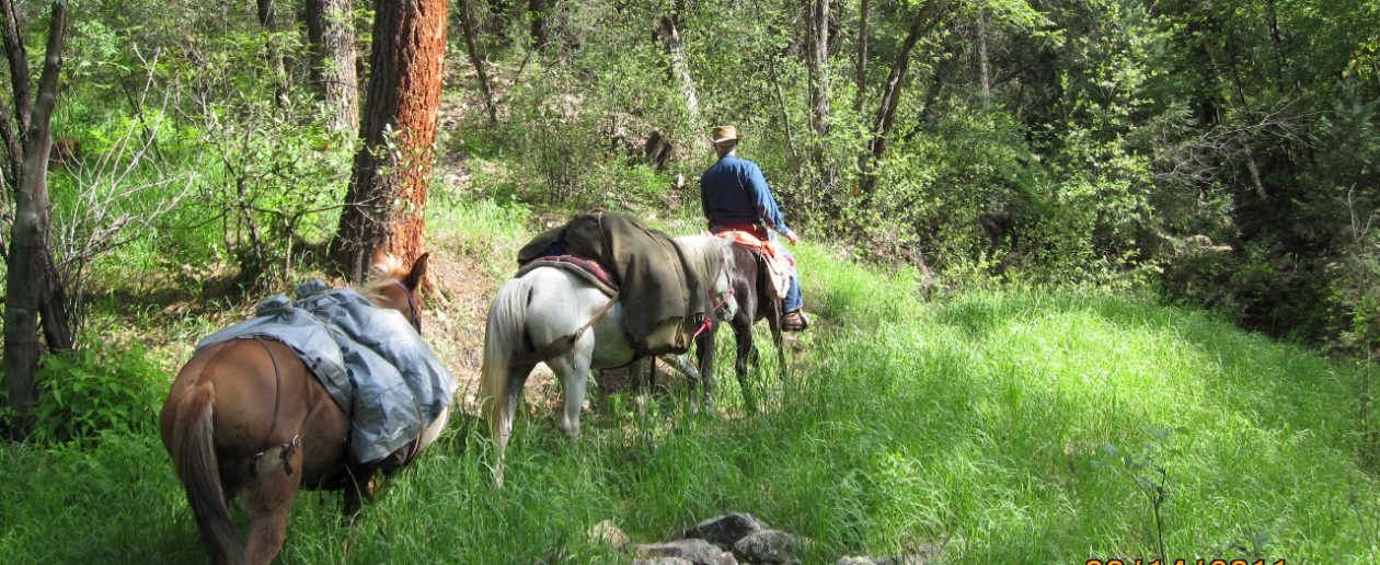
For the day we made 17 miles, which was excellent, considering the first couple miles that day of cutting through the deadfalls. I didn’t get many pictures that day, because all my batteries were exhausted. We had been in thick brush and trees for two days and I hadn’t been able to get enough sunshine to charge anything. My GPS was still at about 50%, so it was ok, but about everything else was dead. During the latter part of the day I was able to tie a solar panel to the back of my saddle and got a 31% charge in my iphone.

On Saturday, day 8, after our obligatory morning oblations, we headed into the mouth of Whitetail Canyon (I think). We started up a trail that hadn’t been maintained in many years, but the trail was marked with rock cairns along the way. Josh had ridden up part of the trail during one of his scouting forays before the pack trip and believed we could make it through the canyon to hit another trail that would take us farther north and exit the mountains at the far north end of the Chiricahuas. As it turned out, we made it up the canyon about 2.5 miles before we just couldn’t go any further. The trail had long before petered out and the canyon narrowed to a mere slit in the rock that was simply too dangerous for us to attempt. We had to backtrack and ended up making camp about a half mile or so farther east down Whitetail Canyon than our camp the night before.
I will say this about the day’s experience: We learned a lot about our little string. Bushwhacking our way up that canyon bottom was some of the toughest trail I have ever been on and our horses handled it very well. I was riding Ranger for the day, and found him to be extremely sure-footed and willing. At one point we had Dad and Josh stay with the pack string, while Al and I went on ahead to scout the trail, to see whether the rest could make it. Al’s mule, I’m pretty sure, is part mountain goat, and he would go through places with ease that I would normally have tried to go around. However, Ranger followed right behind the mule, doing everything the mule did. In fact, there were places Al went around that Ranger went right on through. I was quite impressed and proud of Ranger.
Dad and I set up camp for the evening there in the mouth of Whitetail Canyon, not more than a mile from several houses and what would be our exit from the Chiricahuas. Josh and Al moved on down the canyon and were able to get a ride back to their truck and trailer, parked where we met in Rucker Canyon.

Dad and I enjoyed a nice evening, though we were pretty tired and a bit frustrated at having traveled more than seven miles that day and only making about two miles of actual progress.
The next day was Sunday, so we spent our rest day there in camp in Whitetail Canyon. There was a dry stream bed nearby that had a few small ponds of water in it. We washed laundry in one and I bathed in another. It certainly was refreshing. We had a day of full sun, so I set out my solar panels and was able to get full charges in all our batteries. I took a look at our maps and the topo on my iphone (DeLorme map app) and took a good look at the trail we tried the day before. From what I could tell, we had made it to within 1,000 feet of the trail we were trying to reach. So close and yet so far, as they say. At the trailhead we followed, we had passed a sign that read, “Horse Trail 1 mile.” We must have missed the that trail, if it even exists anymore, because we went in and out of that canyon and never found it.

That afternoon, Josh and Al showed up and brought the gear we had left in their trailer back at Rucker Canyon, including the pack saddle for Daisy (you might recall we had been ponying Daisy bareback the past several days to allow a saddle sore to heal up). They also brought another four sacks of Equidyne for the horses. That was to last us for the next several days until we reached Safford. They left us then and headed back to civilization and their jobs. We sure enjoyed the time we traveled with them and and appreciated their guidance through the mountains. We never would have made it without their help.

So, my next post will cover days 10-14, Monday April 20 through Friday April 24 as we crossed the desert from the Chiricahuas to Safford, AZ.
You must be logged in to post a comment.