Tag Archives: mule

Day 19, Double C Ranch to Clifton

Day 19 for us was a difficult one for us. On this day we came very close to having to put a horse down.

We made camp the night before at a waterhole near the Double C Ranch, in the Black Hills, between Clifton and Safford, Arizona. This area is extremely rough terrain, not so much in the form of canyons and mountains, but in the form of volcanic rock for ground cover. We were lucky to have been able to follow a power line service road through the mountain behind us, because cross country travel would have been nearly impossible on horses. In fact, we had to leave the road once, as we made our way to a cattle watering trough and found it to be extremely slow and careful going. Had we not re-shod the horses the day before, we would have been in real trouble.

On the Black Hills Scenic Byway

On Day 19, however, we were on a dirt road, the old Clifton Highway, now known as the Black Hills Scenic Byway. It is a well-maintained road with little traffic, but it winds up and down and round and round through the Black Hills and seems to go on forever. We found several stock watering tanks, however, so that was nice. We had to watch those, though, because several of them were infested with bees. I’m pretty sure Ranger got a sting on the nose while drinking at one, because he has been scared of metal troughs ever since.

Several miles up the road, a fellow stopped to talk. He was Rocky Menuz, who owns the Double C Ranch. We had elected not to ride up to his ranch the night before, not wanting to bother anyone. It seems some of the ranchers are leery of strange horses, because of communicable equine diseases. Rocky, however, was disappointed we hadn’t called on him. He is a former municipal judge in Clifton. He was raised in the area, his father having founded the ranch many years ago. He knows everybody. What a nice man. He invited us to come back and visit him. He also told us where we would find water along our route.

Grazing in the Gila Box

We finally descended out of the east side of the mountains in the early afternoon. As we reached the valley floor, the terrain softened and we found a very nice grass pasture. We took a lunch break and let the horses graze for an hour or so. It was a nice rest for all of us.

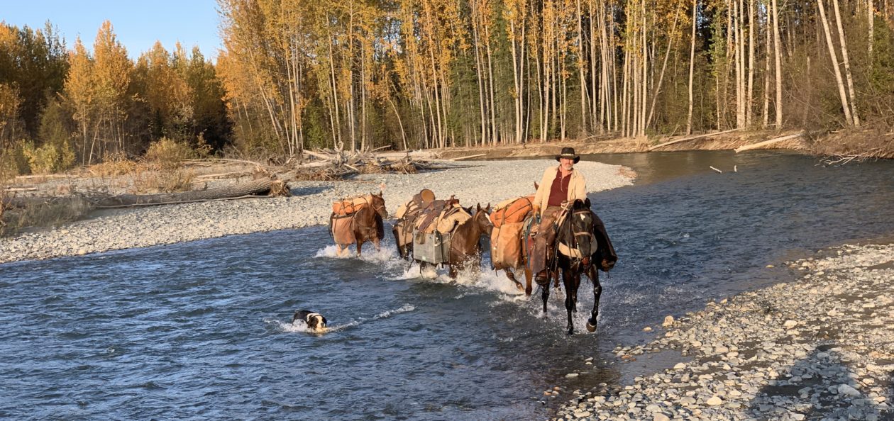
A few hundred feet farther along, we entered the Gila Box Conservation Area. We continued on down the road and came to a ranch a short distance from the Gila River. We met Mr. Menges, who owns the ranch. He gave us some directions for our passage across Highway 191 and on up into the mountains east of Clifton. Turns out there just wasn’t any way to cross that area by trails. We were going to be following dirt roads until we got up into the mountains again. As it was getting late in the day, we asked about water and places to camp on up the road a few miles. He gave us directions to one of his stock tanks a few miles farther up and gave us permission to camp there. He said there was a large covered water tank there, with an access hole on one side, through which we would be able to get clean water for our canteens.  We thanked him and headed on down the road.

Another mile along, we came to a cattle guard on the road where the road was cut out of a sidehill. The stock gate was on the downhill side, where the sidehill had been washed out by the water running through the cattle guard. It was Dad’s turn to get the gate, so he dismounted and led “that stupid mare”, Daisy, through, with his gelding, Black, and the mule, Honey, following. They made it through with no trouble, after a short scramble back up to the road. As I came through, leading Ranger and Jimbo, however, Ranger’s right side pack hit the gatepost, causing him to stumble and nearly go down in the washout. He scrambled back up, but he had Jimbo pigtailed to his pack. About the time he started scrambling, Jimbo’s pack also hit the gatepost and down he went with Ranger tugging on his lead. Jimbo scrambled back to his feet and made it back up to the road, but his pack saddle was listing a bit to the left and his saddle pad was sliding out the back.

About 50 yards down the road we stopped to re-settle Jimbo’s pack. With nothing to tie to, I just dropped the leads of Lizzy and Ranger and went back to work on Jimbo. Dad dismounted from Daisy and tied her to a nearby road sign, with Black and Honey tied to her. Dad and I dropped the packs from Jimbo’s pack saddle and had just started to work on his pack saddle, when all hell broke loose.

That stupid mare, Daisy, trying to grab some grass, tugged on her lead, which was tied to the road sign. That caused the road sign to rock back and forth. Daisy must have thought that sign was about to get her, because she pulled back, pulling the sign right out of the ground! When that happened, Jimbo spooked and started to run down the road away from the ruckus, taking Lizzy and Ranger with him. Meanwhile, that stupid mare was backing right toward the steep sidehill, dragging Black and Honey with him.

I let my horses go and started after Daisy. I tried to calm her as I chased her, but the faster I ran, the faster she backed away. Keep in mind that she was dragging the road sign along in front of her as she backed down the road and it was banging her front legs, with two scared pack animals in tow. Once she realized she was about to back off a near cliff, she corrected and started to back straight down the road…right toward the cattle guard. It didn’t take me long to realize I wasn’t going to catch up with her before the three horses hit the cattle guard.

At that point I did the only thing I could do. I dropped into a crouch and prayed, “Oh Lord, please help us!”

I watched in horror as Daisy backed Black and Honey right out onto the cattle guard. I was amazed to see that both Black and Honey were actually standing on the cattle guard and hadn’t fallen through. Daisy had backed one rear hoof onto the cattle guard, and it went through, so she pulled it back out and stopped. I caught her then, grabbing her lead rope and pulling her forward to allow Black and Honey to move off the cattle guard.

I was able to get her to move forward just a step or two, which allowed Black to move forward. He took one step and his front right went through. He jerked it up, but his right rear slipped through the cattle guard. By this time he had both fronts on solid ground. He jerked his right rear up and out and immediately his left rear slipped through the last rail. He lunged forward and fell. He just laid there. I was absolutely certain he had broken his leg.

By that time, Dad caught up with us. I told him, while I worked to untie the sign from Daisy’s lead rope, that I was afraid Black had broken his leg and we would have to put him down. Suddenly, Black lunged to his feet, standing on all fours. He came up with his head under the hind quarters of Daisy, with his lead rope all wrapped around her, nearly lifting her off the ground. We scrambled to free the lead ropes and get the dang road sign out of the way, and were able to allow Black to slip out from under Daisy.

All three were shaken and upset, but it appeared there were no serious injuries. What a relief. We carefully inspected all three animals and found that Daisy had a scrape on her leg and a cut on the back of her left rear hoof, where she had jerked her hoof out of the cattle guard. Black had similar scrapes and cuts on both his rear hooves, but none of these were serious enough for concern. Black, however, was favoring his left rear and it appeared he had twisted his fetlock joint. It immediately started to swell, but he could walk on it.

Meanwhile, in all this confusion, Honey, simply tiptoed off the cattle guard with no problem at all.  She had not a scratch on her. That’s a mule for you.

We got Daisy and Black settled down and checked over, then turned out attention to the other three horses that had run off down the road.  There they were, standing in the road about 200 yards away, all three side-by-side, heads up, ears perked, looking at us like they were very concerned about their traveling mates. They let me walk right up to them. While Dad led his horses, I gathered mine up and we got off on to a side road, where we could work on Jimbo’s pack saddle and get him loaded back up without blocking the main road.

Dad and I were both physically drained as the adrenalin eased off. We were tired and shaky after the event, and very grateful for our good fortune in what might have been a true disaster. Prayers of thanks were offered. After re-packing Jimbo, we mounted up and continued on our way. Black’s rear fetlock swelled, but seemed to go down and become less painful as we went along. He did not limp or favor it, so we felt confident in continuing. We gave him some of Daisy’s bute that evening in his feed (another providential blessing that traced back to our friendly lost dogs back on the Gila River).

We passed two nice camp grounds right on the Gila River, but horses were prohibited in both.

About another half mile, we came to another cattle guard. This one had no stock gate at all! It was unbelievable to us that in cattle country the state would make a cattle guard with no way to get livestock around it at all! So, we did what any self-respecting horse packers would do. We headed back into the nearby campground and found our way up a wash behind it, to that same fence line, and we lowered the fence. After crossing all the horses, we re-attached the fence and left it as good as before. In order to get back to the road, however, we had to climb some bluffs that were steep, but not too high. Once back on the road, we went about another three miles and located the stock tank Mr. Menges had directed us to. It was a fine sight for us after a hard day.

We watered our horses at the trough, then looked around us. There was absolutely nothing growing in the area but greasewood bushes. Nothing to tie our horses to for the night. We ended up tying a loose bowline around the bases of several greasewoods, tethering the horses by their front left pastern. It took a little getting used to for them, but after a few slight tangles and tugs they figured it out. Ranger gave us a humorous moment. While he was looking for grass, he turned around several times, effectively hog tying himself with his stake rope. Then he simply tipped over. No big fuss or struggle, just tipped over. Dad got over to him and untangled him before he got upset. All the animals were fine the rest of the night. We fed them a good helping of Equidyne in their nosebags.

Phelps-Dodge mine at night

By this time it was dark. We enjoyed the view of the Phelps-Dodge mine at night, with all its lights.  What a marvel of engineering that place is. There were plenty of stars overhead as well. It was a peaceful evening.

Dad and I ate our usual re-hydrated corn chowder and hit the sack. The excitement of the near-disaster had completely drained us and we slept soundly. We made 16.8 miles that day.


Ride to Swinging Bridge, along the San Rafael River, southern Utah

Two weeks ago I was invited along with Jon Tanner and Casey & Erin Johnson to head down to the San Rafael River for a ride. The area we went to is commonly known as Swinging Bridge, named for the old wooden suspension bridge that used to carry the road traffic across the bridge. I thought crossing that bridge might be a good training exercise for my horses. We will have to cross a swinging bridge in the bottom of the Grand Canyon at the end of June on our big pack trip and I sure would hate to get there and have the horses balk.

The route from the Utah Valley (Orem/Provo/Spanish Fork) area is to take US Route 6 to Price, then State Route 10 about 29 miles south to USFS 401 (also known as Green River Cutoff Road), which is a well-maintained dirt road, just north of Castle Dale. If you hit Castle Dale, you missed the turnoff. Turn left (east) on USFS 401 and follow it about 16 miles, to USFS 332 (also known as Buckhorn Draw Road). You will pass two major intersections and USFS 332 on the north side before you get to the 332 on the south side, so just make sure you stay on 401 until you see the sign for USFS 332 on the south side of 401. Take USFS 332 south about 10 or so miles further, until you pass the old bridge over the San Rafael River. There is designated (primitive) camping in that area, but you can go on another 1/2 mile and make a right (west) and go about 3/4 of a mile and you will find another designated camp area with a half-decent corral.

At the equine camp area near Swinging Bridge

There is no water at the camp area and no facilities. The river is easy to access and close enough to water horses.

The trailhead leads directly off from there, westward, up the “Little Grand Canyon”. It’s best to go with someone who’s been there before, because in some places the trail has seen insufficient use to be clearly marked and it is not maintained. Some parts of this trail are pretty spooky for horses and riders unused to the rough country, however a decent trail horse can negotiate even the toughest parts safely. I personally do not recommend this trail for people and horses that have not done a bit of back country riding. It is not a “walk in the park,” so to speak. The trail we rode goes up the canyon a ways, then turns off into a side canyon to the south that dead-ends at Virgin Spring. The spring is a pool of clear, cool water larger than your average swimming pool. A nice place for lunch.

Virgin Spring
Virgin Spring

You can also continue to follow the river and main canyon on northwesterly, on up to Fuller Bottoms. I’m told it’s about another eight or so miles. It would be a great ride if you had someone to pick you up on the other end.

Just a note about the trail: There is quicksand in the river bottom and in some other places where water occasionally stands. Be careful and pay attention to your horse. Many of them have a sense about quicksand and can keep you and themselves out of a world of trouble. Stay to areas where other animals cross, such as cows, horses, and mules.

We rode in on Saturday morning with our group along with a group of mule riders. We crossed paths with a number of hikers and backpackers, so be aware and please be courteous. Leashes are not required on dogs. It is an excellent trail on which to have your canine trail companions along.

Reno in his first packing training experience

On this particular trail, I decided to train my new young gelding to pack. He’d never had a packsaddle on, as far as I know, and I’m sure he’d never before encountered hard paniers. I put my newly acquired TrailMax bear-resistant hard paniers on him and dropped a 50# sack of feed in each side. When we started down the trail we were dead last in the group – on purpose. We had us a pretty good little rodeo there for a few minutes as Reno and Ranger got used to the sounds and feel of the hard paniers. After about a quarter mile they began to settle down enough for me to handle them. Reno, scared of the paniers and experiencing packing for the first time, kept wanting to come up alongside me. I was afraid he would end up pushing Ranger and me off the trail and down the mountainside. After a few good whacks on the nose with his lead rope he finally recognized the wisdom in staying back and following behind.

The easy part of the trail

The trail turned out to be an excellent training experience for my pack horse, however, had I known beforehand what we faced, I wouldn’t have packed him or ponied him along. We passed through willow thickets, standing rocks, narrow trails on cliff faces, river crossings, very steep ascents and descents, and even quicksand in the river bottom. By the time we finished our ride for the day, about 16 miles in and out, he had learned about walking around things, rather than trying to bull through everything. One thing is sure, he proved to be a very sound and level-headed horse. Even when he got “pinched” between a couple rocks, after trying to get through a couple times, he stood still while I unbuckled straps on one side, so I could lift the panier over a rock. As I did so, he calmly walked on forward to get through, then allowed me to re-rig the panier.  I was very pleased with him.

Due to the fact that I had one hand on the reins controlling Ranger, and one hand on the lead rope handling Reno, I was unable to get more than just a few photos and no video at all. Sorry. I’ll get some next time.

All-in-all, it was a great ride and one I plan to do again.

Gear Report: Goal Zero Solar Chargers

Goal Zero Nomad 13 and Guide 10

Thought I’d take a few minutes this morning to type up a gear report on one of the pieces of gear we took that truly proved its worth and durability on our 355 mile horse pack trip through the rough country of southeastern Arizona:  Our Goal Zero solar chargers.

As you might recall from a previous post, I bought two solar chargers made by Goal Zero – a Guide 10 and a Nomad 13. The Nomad is the larger of the two panels, producing up to 13 watts of electricity, while the Guide 10 produces up to 10.

Goal Zero Guide 10
Goal Zero Guide 10

The reason I bought the Guide 10 to supplement the Nomad was that it comes with a rechargeable battery pack of four AA batteries that can be used as an emergency power source to recharge our other electronic devices when no sunshine is available.

Tough covers and clear plastic protecting the solar cells

When I first purchased the chargers I was quite concerned about their durability. They are flat-panel solar panels covered by a tough nylon-canvas material with a clear plastic cover over the solar cells. They both have a zippered pocket on the back, where cords and adapters may be stored. I am pleased to report that these panels have survived the first leg of our trip. 355 miles of the toughest terrain I have ever ridden over.

As I felt I needed to keep these panels accessible at all times, as well as the need to protect them from damage, I kept them in my saddle bags for the entire ride. My original intent was to strap them to the top of our pack saddles, so we could charge batteries and devices as we traveled. However, after our first day out, I let that idea die. We passed under so many low branches of mesquite, ironwood, juniper, ocotillo, and cactus, that I’m pretty sure they would have sustained damage had I tied them to our pack saddles.

My solar panels set out to charge my iphone

What I ended up doing for most of the trip was to set the panels out each morning and evening to catch as much sunshine as possible. Often, we made camp after the sun was low on the horizon, so I didn’t get a lot of charging done in the evenings, but I generally got several hours of good charging time each morning as we broke camp. My solar panels were the last thing to be packed before mounting up.

About the second week, we had a spell when there just wasn’t enough sunshine to keep our batteries charged, partly due to our traveling through trees in the Chiricahuas. I ended up one day with all my GoPro camera batteries discharged, my iphone dead, and my DeLorme Explorer GPS almost dead. Out of necessity I tied the Nomad 13 to the back of my saddle as we traveled in open country from the Chiricahuas to San Simon, AZ. 20150429_114019The canvas cases for both units have small loops along outer borders which serve very well for tying them by saddle strings over my coat behind my saddle. While it did not charge very efficiently, due to not being able to always have it directly facing the sun, it was enough to get my iphone up to about a 30% charge after several hours. After that, whenever we traveled in open country I tied the Nomad to the back of my saddle and connected something to it, be it my iphone or the Guide 10 battery pack. In that way we were able to keep the most critical devices with at least a minimum charge the whole trip.

Another benefit of having both the Nomad and the Guide 10 was that the two can be connected together, or “daisy-chained”, by connecting the built-in cables, to increase their charging capacity. This greatly decreased the amount of time needed to completely recharge a device or top one off. When I set the panels out each morning or evening, they were daisy chained and I took pains to make sure the panels were situated to take maximum advantage of what sunshine was available. I found that even on cloudy days, there was sufficient sunshine to produce a trickle of electricity to get some charging done.

Guide 10 battery pack

The item I always gave priority to keep at full charge was the battery pack. The battery pack contained four rechargeable AA batteries and had sufficient depth to bring my iphone 6 from dead to about 95% charge in a matter of about 3 hours. At that point the battery pack would be completely dead. I would make sure it was brought to full charge the following morning. My reasoning for this was that my iphone was the second most important electronic device in our inventory. It communicated with my DeLorme Explorer and provided viewable topographical maps by which we guided ourselves much of the time. Since we didn’t get all the paper maps we should have, we were very reliant on the iphone to keep us going the right direction, particularly at forks in the trails. It also served as a camera for still shots and the occasional short video when I didn’t have the GoPro out and ready. The battery pack gave us some insurance against days without sun and was used a number of times to keep the iphone alive until it could be charged by the solar panels.

Indicator light, USB output, two power inputs, LED flashlight function on the battery pack

One end of the battery pack has a well organized set of power inputs and outputs, as well as an indicator light and LED flashlight function. The USB power output allowed us to use the regular USB charging cords for charging all our devices. The inputs allow charging from the solar panels via a built-in cord or from a 110V wall outlet via a USB charger. When the battery pack is discharged, the indicator light shows solid red. As it charges it shows a blinking red light, which changes to a slow-blinking green, then a faster-blinking green, then finally a solid green when fully charged. The same indicators show as it discharges while charging a device. There is an on/off switch on the left side which also turns the LED flashlight on and off. While I never needed the LED flashlight, I can see where it might come in handy on occasion. The pack also comes with an adapter to recharge AAA batteries. The reserve power of the battery pack was a very important asset for us on the pack trip. In fact, I am considering purchasing a second battery pack.

The most important device we had was, of course, the DeLorme InReach Explorer, however the settings I had in place on it kept it going for up to five days before hitting the critical 20% charge level. Not only that, but it would come back to full charge within about two hours, when connected to both panels in direct sunlight. So, one good morning would have the GPS set to go for nearly a week.

I made sure all our devices were turned off each night and not turned back on until needed the following day. By doing so, and by ensuring that I set the two chargers out each morning, along with the additional charging time on the back of my saddle, the two solar chargers kept all our devices with at least a minimum charge the entire trip, except that one day when I let things get discharged. That one day taught me to become more diligent and organized in keeping things charged and utilizing the sun when it was shining. Additionally, as we took a rest day every Sunday, the solar panels were set out all day and adjusted periodically to maximize their effectiveness in the sunshine, while charging all our devices to maximum capacity (that is, when the sun was actually shining).

As for durability, while stored in my saddlebags, along with a number of other items – flashlights, binoculars, odds and ends, etc – these two solar charges survived multiple instances of my saddle horse laying down and attempting to roll over. I can’t think of many more effective ways to prove the durability of these little panels. After the trial they have been through, I am satisfied that I will have them for many, many more miles into the future.

wear spots on the plastic solar cell protectors

The only thing I have found that would improve the durability and effectiveness of the Goal Zero solar chargers, in my opinion, would be to have a piece of flanel cloth, or similar material, cut to the size of the panels to keep between the clear plastic panels when the units are closed. I found that the clear plastic face of my units became scratched and had a somewhat fogged appearance in places, from the dust that got between them and scratched the surfaces while closed. I’m sure that decreases their efficiency, although I don’t know how much. This little improvement is something I will do for future use. I intend to recommend this as an improvement to the manufacturer.

My overall evaluation of the Nomad 13 and the Guide 10, used both individually and together, and I think I can honestly say they received a baptism by fire, so to speak, is that I consider them to be one of the most critical items of gear we had on the trip. That is not to say they were necessary for our survival, but they were absolutely necessary for the successful outcome of our trip. They proved themselves to be very durable under the most harsh conditions, surviving some pretty rough treatment and kept our critical electronic devices with at least a minimal charge throughout our month-long trip, thus ensuring we had the ability to contact the outside world at any time and that we were able to photographically document much of our trek for our followers.

Overall grade:  A+