Seems I have been so busy with life that I seem to be forgetting to live.
Hehehe. That sounds really good and rolls off the tongue nicely, but it really isn’t the truth. The truth is that I have, in fact, been busy, but not so busy that I couldn’t take the time to hammer out a few posts. I have been lazy and remiss. That is the fact. My mind has simply been on other things.
So, I’ll catch everybody up on what has been going on and what I have planned for the not-too-distant future.
Chief, brand new, not even an hour old.
First off, I’m sure my readers are aware that my mare Lizzy had her colt on September 14. He’s now two months old and growing fast. He’s a handsome fellow and will be a credit to his sire and dam. He was born a sorrel and white tobiano, but has since changed colors drastically, to black and white. He is still showing some sorrel highlights and there is some sorrel still in his mane and tail, but I’m pretty confident he’ll end up black and white. His registered name will be Touch the Clouds, named after a Sioux war chief from the late 1800s, known for his great height (he was about 6’5″ and 260 pounds by one account) and strength. His barn name is Chief. I have the papers in process, but had to call the Missouri Fox Trotter Horse Breeders Association and have them hold off when he started changing colors. His photos and description would have been wrong! I sent in a DNA kit as well, so he’ll be “gold-papered.”
Chief at one month, changing colors
Over the past several months I have been working to earn money to pay for some improvements on my place in Eagar, Arizona. I had actually planned to spend the money on refurbishing my horse trailer and finishing out the camper compartment this year, but after spending some time in Eagar with my parents and spending some time walking over and dreaming about my 20 acre parcel there, I decided my priority should be getting that place to where it can be productive and actually pay for itself.
So, a couple months ago I bought a load of 4-1/2″ pipe, so I could rebuild some fences, start a pipe fence on one side of the place, and build some corrals and a pole barn. Dad and I got started on it a few weeks ago.
In the process, I came across a tractor in Eagar that had been sitting in a yard for a long time. I made the owner an offer, which she accepted, and I took it home. Drove it home, actually…well, to my place there in Eagar. So I am now the proud owner of a 1962 John Deere 3010 Diesel tractor and several implements, all in need of some tender loving care to make them work again. I don’t know what it is about old stuff, but I thrill over making broken stuff work again.
My JD 3010 Diesel with post hole digger
The tractor is now running and working, after adding about $2,500 in parts to the initial cost of $1,500 (and $500 for the implements). I’m told I’m still under the value of the tractor, so I’m happy.
Last month I bought a new heavy-duty three-point post hole drill and a couple augers, which ran about $1200. Dad and I punched a bunch of holes with it and set some fence corners and line posts as well as all the upright posts for a pole barn and corrals. I also spent about $1,500 for lumber for the barn and shed roofs. Now I need to save up some money for the metal roofing and siding and some pipe for the pipe corrals and fences.
The corrals will be 16′ wide and 42′ long with a 32′ X 16′ hay barn at the east end and a shed roof covering the south end of the corrals. I like the plan and will likely expand it to add more corrals as the need arises.
Setting posts for corrals
As I increase my little herd, currently three horses and a colt, most of them will be kept on the place in Eagar most of the year. Several close relatives also keep their horses there. I hope to end up with several more horses and a couple mules eventually.
The plan is to split the 20 acres into four 5-acre pastures, with the southernmost being used for barns, corrals, arena, training area, and trailer parking. The other 15 acres will be pasture, which I hope to be able to irrigate from a well. There is a dry irrigation pond at the northwest corner of the place that used to have tail waters from two irrigation ditches running into it. A number of years ago the ditch company put those ditches in pipe and the former owner of my place sold off the irrigation shares, so the pond is dry. My intention is to hire somebody to expand and deepen the pond and level out the banks, so that it actually resembles a pond about an acre or so in extent. I hope to have a well drilled near it and install a windmill on it to fill the pond and maintain a constant flow. I will then irrigate the whole acreage from the pond.
My place, looking northward
My place has a well down at the southwest corner that has been tested at 65 gallons per minute. I’m in the process now of getting it back into working order – new pump and controller, well head, etc. However, 65 GPM is a bit low to effectively irrigate the whole 20 acres. If I can fill that pond from a separate well with a windmill on it, like plan to, I can irrigate directly from the pond at the flow rate I need to maintain the proper pressure and flow rate to the sprinklers.
As I was working all this out in my head (since I don’t actually have the money to do it right now) it occurred to me that my place might make a good place for folks coming to the White Mountains with their horses to stop over. I participate in a number of forums and facebook pages about horses and I have noted that every day there are folks seeking “horse camps” where they can park their living-quarters trailer overnight as they pass through the area, or for several days while they ride local trails. I posted a query to one of those groups to try to gauge the interest and see whether it would be a good idea for me to try to place several short-stay RV spaces on my place for horse-campers. I was surprised by the response. It appears there is plenty of demand for such a place, even in little old Eagar, Arizona! There just aren’t enough places that cater to horse folks.
I also received more than one query in the responses about long-term horse boarding on the place. Maybe I’ve found a way to make the place support itself after all.
So, my plan is to approach the Town of Eagar and find out whether they will allow me a permit to install maybe 10 short-stay RV slots on the place, along with a bathroom and shower, with full hookups and a dump station. If the town allows it, I will start with five spaces and go from there. l’m not sure they will allow it. If not, I’ll just look at boarding horses. We’ll see how it goes.
And now for the grand finale – for this post, at least. I have set the dates (tentatively) for the next leg of my Mexico-to-Canada trek. Dad and I have discussed ways to make our pack trip a bit easier for our better-halves to deal with. We decided that if we cut it up into legs of 7-10 days, rather than a month at a time, we might just be able to finish the ride before we’re both too old to ride.
So, since we had to stop in 2016 at Flagstaff, Arizona, having made a grand total of 555 miles since we started (at least that’s what the GPS said), we plan to start right where we stopped and go to the North Rim of the Grand Canyon. Yes, we will be crossing the Grand Canyon on this leg…finally! As close as I can figure, the distance to the South Rim is about 108 miles. The distance rim-to-rim is about 22 miles or a bit more, so we’re looking at a grand total of about 130 miles. Toss in two rest days and maybe another day at the Grand Canyon as a fudge-factor, and I think this will be a 10 or 11-day trip.
So, I will be applying for a back-country camp permit for the Grand Canyon for May 1 and 2, 2018. Which means we’ll be departing Flagstaff on April 23, 2018. If we have a mild winter, that time frame should have good grass growing along our route to keep the horses in weight without us having to haul all our feed and should have the water sources along the route full. At the same time, it should get us through the Grand Canyon before the mad summer rush begins.
We will end this third leg of our trip at the North Rim, where we’ll be picked up to return us and our horses home. That should have us home by the weekend of May 5.
A couple of my riding friends have expressed a wish to make the trip with us, so this should be fair warning to them! I’ll get in touch with you shortly, so we can all plan toward it.
I recently created a new website for a sports fan group I have belonged to for more than ten years. We are die-hard fans of everything related to Brigham Young University sports, especially football. We had been using a forum service, YUKU, for a lot of years and finally got tired of the poor service and goofy advertisements they slipped into our forum. We had to pay a fee not to see advertisements. Finally we got so fed up with it that we began to talk about looking for a new home for our forum. As we discussed it, I realized that it would be a pretty simple solution for us to buy a domain name and create our own website and forum. So, that’s what we did, using my web hosting account with Bluehost. So, I created byufans.net. It is a closed group, though, so membership is limited to the current members and those individuals who are personally invited by a member. Sorry.
Anyway, what does that have to do with Western Trail Rider? Well, the new website looks so good and works so well and is so easy to manage that I was quite impressed with myself (hehehe). But, when I switch over to my WTR site, well, it started looking a bit drab and old. Now, every time I look at WTR I think I need to update it.
So, I’m going to be looking at new themes and other apps and programs that might sort of dress up the site and make it more user-friendly and easier to manage. Once I decide what to do, I’ll let everybody know that it may be down for a few hours…that is, if everything goes well…or a few days, if I mess up. Now, nobody need suppose that I am a website developer or otherwise expert, or even knowledgeable, about websites and blogs. I just trip along until something looks pretty good and works ok. WordPress has made things pretty simple for guys like me. It is mostly a matter of figuring out what I like, then plug-and-play. Still, I seem to be able to mess things up pretty well, as I try mixing and matching different services on the site. The challenge is going to be ensuring that I don’t lose any of the photos, information, posts, and serviceability of the current site.
Also, I understand how each provider of an app or service can spend thousands of hours developing a simple app for dummies like me to “plug-and-play” and that they certainly deserve to be paid for their efforts. However, when a guy like me starts adding up the various fees and subscriptions and donations, the cost starts to reach a significant level per year, particularly when I am not making a penny on the website.
I created the website shortly after I started planning my big horse pack trip a few years ago. A number of folks suggested that I start a blog, so they could keep up with my planning, gear purchases and reviews, and other developments, as well as documentation of the trip itself. It occurred to me that I might just as well purchase a domain name, start a website of my own, and invite other horse and trail riding folks to blog along with me. The thought was that we, together, might create a website where like-minded people might come to find information about horse trails in the western U.S. and to get first-hand information from people who had actually ridden those trails. I’m not talking about state and national park trails – there are numerous websites for those places. I’m talking about the backtrails and places that are almost unknown except to riders from the local areas. Places folks hear about, but few ever see. I figured that eventually there might be enough bloggers on the site that a little advertising income might be generated, to pay for the website maintenance. That hasn’t developed, so I’m content with simply using the site as a place to document my horse adventures for a few faithful followers to enjoy.
Still, I’d like to make it an attractive and interesting website. So, I’ll be working on updating it over the coming couple of months.
Stay tuned to see what I come up with!
P.S. The invitation is still open for anybody who would like to start their own horse-related blog under the WTR banner or to link an existing blog through WTR. The only requirement is that it be related to horse trails in the western U.S. or some aspect of horse or mule packing. There is no charge and I maintain the site at no expense to you…unless you would like to help out. If you have interest, send me an email at tony.henrie@westerntrailrider.com.
I have a goal of riding all the trails that head on the Mount Nebo Loop Road, south of Payson, Utah, within the next year, so I try to hit a new trail every chance I get. As I get through those trails, I will start on the trails on and around Mount Loafer.
My rig in the Jone Ranch parking area
Yesterday, my wife and I tried a new trail which heads at the Jones Ranch parking area about 9 miles south of Payson on Mount Nebo Loop Road. It was a nice three-hour ride. Linda rode my mustang Jimbo, and I rode my paint Quarter Horse, Reno. I ponied my Fox Trotter, Lizzy, along just for the exercise and because she really wanted to go with us. She got pretty upset when I took the other two to the trailer and didn’t take her.
The Jones Ranch parking area is adequate for even pretty large rigs to enter and turn around. There are no services offered. There are some primitive campsites around the parking area, but no hookups or conveniences. Some folks set up camp and spend several days riding out on the various trails. The best campsites seem to be right at the trailheads, so expect to have folks passing through or next to your campsite. These trails are “multi-use” trails, so they are open to hikers, horses, bicycles, and motorcycles. Most of the trails are well-maintained and fairly well-traveled. Expect to pass other folks on the trail. Dogs are allowed and not required to be on leash, as long as you are outside fee areas, like Payson Lakes.
On this ride, Linda and I chose to ride the Jones Ranch Creek trail, Forest Trail #123, which heads south from the parking area. The trailhead is on the south side of the road and continues southward. Again, the trail is well-marked and well-traveled. Can’t miss it.
Linda on Jimbo
The trail starts out climbing at a slight grade and heads up through spruce and fir forest, as well as aspen groves and a couple of nice open areas. It crosses two or three spring-fed creeks and is a very pleasant ride, suitable for even the very youngest and most inexperienced of riders. The elevation at the trailhead is around 7,000 to about 7,200 feet. This trail is about three and a half miles long and ends up back at Mount Nebo Loop Road near the Payson Lakes ranger station a little higher up the mountain.
The “scariest” obstacles we encountered on the trail were a couple of places where small culverts have been placed and covered with gravel and lined with landscape timbers. Our horses sort of eyeballed them, but passed over without complaint. There is plenty of room to go around these bridges if necessary. There is one gate to be opened and shut about 3/4 mile from the trailhead.
Junction of FT #101 and #097 looking at Mount Nebo
About two miles up the trail, the Rock Spring trail, Forest Trail #101, intersects it. We elected to take the Rock Spring trail to check it out. This trail heads southwesterly, climbs a bit, then descends, then climbs again, offering some very nice views of the surrounding area. Again, this trail is not challenging and is suitable for anyone who enjoys riding in the mountains. We followed it about a mile and a half, then turned south on an intersecting trail, Forest Trail #097, that shows on my USFS map as a “Jeep Trail”.
We followed this trail south, climbing steadily, about another mile and a half to its head at Mount Nebo Loop Road. I noticed that near this trailhead, on the south side of the road, there were a few nice primitive campsites. It occurred to me that one could set up camp here and enjoy several days of nice riding.
At this point we turned around and headed back. My USFS map from about 1967 or so, showed a separate trail paralleling trail #097 back to Rock Spring Trail, so we decided have a look. It is not marked and started out as a two-track that descended into a canyon (ergo the “Jeep trail designation on the map), ending at a “yurt” type domicile. We avoided that and tried to continue on the trail indicated on the map. Following my GPS we found where the trail was supposed to be, but it was nowhere to be found. It appears that it was a trail at one time, possibly used by the old ranchers, but through disuse it has simply disappeared. We bushwhacked for about a half mile to get back to Rock Spring Trail. The bushwhacking wasn’t bad, as the terrain has a gentle slope and the vegetation is not closed, like an oak thicket would be, so I actually enjoyed just following my nose. My wife, however, did not enjoy it and expressed concern that I might be lost (Word to the wise: Don’t try bushwhacking in the mountains with someone who isn’t comfortable with it). Alas, we found the trail right where we left it. Of course, I knew where we were the whole time.
On the way back, on FT #123 looking northward at Mount Loafer
The ride back to the trailhead was as enjoyable and relaxed as the ride out. It took us two hours to get to the Forest Trail #097 trailhead and, as usual, about half that to get back to the Jones Ranch trailhead. It was a very pleasant three-hour ride in which we covered just under five miles (we take things pretty easy).
My horses were barefoot on this ride. I pulled their shoes and trimmed them all in the past week. They got a bit tender toward the end of the ride, due to the sharp rocks on the hard trail. None of the horses got stone bruises or received any injury, however, and were simply a little tender toward the end. I feel like this trail is suitable for barefoot horses for a day ride, but if one were camping and riding for a week in that area they might get uncomfortably tender.
Me on Reno, ponying Lizzy
Trail notes:
From the junction of #097 with Rock Spring Trail (#101), you can also head northward and explore several other trails down in that area. You can get back to Mount Nebo Loop road at two or three other places as well. I’ll be riding and reporting on those trails in the future.
Well, sad as I am to say it, our pack trip has ended at Flagstaff, after about 197 miles of travel.
Temperatures are at record highs. Fire danger is extreme. There is no water in northern Arizona anywhere along the Arizona Trail.
Last Monday we made 23.8 miles and the last water we saw was near Marshall Lake at about mile 3-4. By the time we made Flagstaff we knew we were in trouble. The last 6 or so water holes we passed were bone dry. We finally had to call Gwen and Bruce Kahler, who hauled about 70 gallons out to us and met us where the AZ Trail meets Route 66. That supplied ourselves and our horses for that night and the next morning.
Gwen Kahler, our guide through the Flagstaff area
Gwen stayed and rode with us on Tuesday, as we finished the AZT Equine Bypass route through the mountains and around Flagstaff. We passed one running stream (only the second we had seen the whole trip) as we headed back up to higher elevations. We made Schultz Tank, which had water, by about 3pm. From there it was only about four more hours of riding to reach Gwen’s place, so we decided to make the push. We reached her place by about 7pm, making a 19.2 mile day.
On Wednesday, as we were running errands, re-supplying ourselves for the second half of the trip, I contacted the USFS to ask about conditions between Flag and the Grand Canyon National Park. The answer I got was disheartening. He said we would find water in the higher elevations just north of Flagstaff, but once we dropped down into the lower elevations on the AZT we would find none. That meant we would have about 95 miles of dry terrain with no water for ourselves or our stock.
Gwen got on the phone and started making calls and texts and was able to recruit help in hauling and locating water for us so that we could make our dates at the Grand Canyon. Gwen was going to ride with us to the South Rim, so she had a vested interest. It began to look as though we were going to make it at least that far.
Once at the Grand Canyon, we would have water, as the park has provisions for both potable water and stock troughs. However, once we left the North Rim campground, we would face another 100 miles, approximately, to the next reliable water source, the Paria Creek. As for feed, we had plenty of grass in the higher elevations, but there was very little once we dropped down into the Junipers. We could not pack more than enough feed for a day or two.
This is the driest year I can remember for Arizona. There are fires all over the state, we have already had to re-route around one major fire and were lucky enough to have passed through a couple more areas before they were restricted due to fires.
On Wednesday, the USFS announced open-flame prohibitions on the areas north of Flagstaff, through which we would be riding. We used a small single-burner stove for all our cooking needs, so that didn’t restrict us, but it shows just how dangerous the situation has become.
At the Kahler’s place we were able to find a large animal vet to come out and do the health checks on our horses and mule, so that we had current certificates to enter the Grand Canyon National Park with. We also found a farrier who was willing to come out and re-shoe all our stock on short notice. We were in the middle of getting that done on Thursday, when we got the phone call that was the last straw.
My mother had a very rare and serious reaction to a prescription medicine and had been hospitalized.
It was time to stop and take care of more important business. My sister and brother-in-law came up and picked us up at the Kahler’s place that evening. Dad and I drove back up and hauled the horses back to Eagar on Saturday.
Mom is doing better now and the emergency has passed. She was home before we got home. Dad and I got to thinking we might haul the horses to the Grand Canyon and do the ride there, since I already have the permits and reservations in place and paid for. Mom gave us the go-ahead, but looking at the forecast for the next week, it appears the Grand Canyon will be experiencing record high temperatures. This has been one of the hottest and driest springs on record for Arizona. I have already lost one horse on this trip. I am not willing to risk losing another to the extreme heat in the Grand Canyon, nor to risk Dad’s or my own health any further.
Fact is, this just isn’t the right year to be attempting this ride.
On our pack trip last year, everything worked like clock-work. Things simply fell into place. This year has been different. We have fought through every kind of complication. If something could go wrong, it did. It’s time to stop before something goes really wrong and somebody gets hurt. This trip has already cost me a very good horse. The warning signs have been getting louder as we go. It’s time to concede and head home.
On the Mogollon Rim. Thanks to the Bergs for the photo
Be assured, the trip has not been wasted; Dad and I had some very rewarding days and we passed through some beautiful country. We have been pleased with the AZT and impressed with the care and maintenance most of it has received. We have seen dozens of elk, deer, and antelope, and ridden trails most folks will never see. We have enjoyed the ride immensely. We have experienced something most fathers and sons will never experience.
We’re sorry we aren’t going to make it all the way, but we want to assure all those who have helped and encouraged us along the way, that this was not wasted time. It was all a good and rewarding experience for Dad and me. We are truly grateful for all the help and support we have received.
I will post photos and a trip log after I get home and get settled. The Internet service here in Eagar is not sufficient for me to upload photos. I expect it will be a couple weeks.
After making several drives and looking over our proposed route, as well as a lot of Internet research, here is what we know so far about our route and time frames for travel.
First of all, there are a couple of dates that are hard and cannot be changed. I have Backcountry Camping Permits for the Grand Canyon National Park for June 29 and 30, 2016 for four horses and two people. Those are very hard to come by, and I was very lucky to have landed it. Those dates are fixed. The second date is the Pioneer Day Parade at Panguitch, Utah. That will be on July 23, 2016. This will also coincide with the 64th class reunion of Panguitch High School’s Class of 1952, Dad’s graduating class. We cannot miss those dates.
So, with that in mind, here goes.
We originally planned to depart on Dad’s 82nd birthday. We had to postpone that one day, so I could see one of my grandkids…and my daughter of course., who will visit from Texas to see us off. So, we will start making tracks on Tuesday, May 24, 2016, from my pasture at 217 N. Poverty Flat Road, Eagar, AZ, 85925. Anybody who would like to start the ride with us should be there ready to ride by about 10:00am. There is plenty of parking for trucks and trailers.
We will follow Route 260 west until we start up into the mountains, at which time we will take Forest Road 1235 north for a short ways. We will depart that road when it turns northeasterly and head directly west, cross-country. We will then join FR 117, which we will follow until we come to FR 61. We will take that to FR 96, then on to FR187, until we arrive at Sky Hi Road, Pinetop, Arizona, at the trailhead for Maverick Trail in the White Mountain Offroad Trail Association trail system.
This trailhead may be reached by taking Route 260 in Pinetop to Buck Springs Road, then north about 1/2 mile to Sky Hi Road. Turn left and follow Sky Hi north for two miles, until you come to the trailhead on the left.
We will follow the Maverick trail 50 miles to Clay Springs. We hope to be re-supplied for horse feed there by a friend from Pinetop. We will then connect with the General George Crook National Recreation Trail, which we will follow westward to join the Arizona Trail (AZT). We expect to reach the AZT by about Tuesday, June 6. We estimate 150 miles for that leg of the trip. The Mogollon Rim Road generally parallels the Crook Trail, so anybody wanting to find us may do so at a number of points along that route.
We will then follow the AZT north to Flagstaff, about 105 miles, more or less, and re-supply at the home of Gwen Kahler. We should arrive there about June 16 or so. We will probably rest there a day to have our horses re-shod and to get new health certificates for the horses (they must be current within 30 days to enter the Grand Canyon National Park). Once we hit the trail again, Gwen will ride with us for a few days. She will guide us through the area, hopefully bypassing a section of the AZT that is currently in bad shape with blow-downs. Anybody wanting to find us along that leg of the route may do so at various points where the trail intersects a number of Forest Service roads or at Mormon Lake.
The distance from Flagstaff to the South Rim of the Grand Canyon is about 108 miles. That should take us about 6-7 days of travel. Add two rest days in there and we should arrive on or about June 27. We have an equine campsite reserved at Mather Campground at the South Rim from June 25 through July 2. We hope to be able to make up a little time en route, so we can arrive on June 25, to allow ourselves and the horses some time to rest before our crossing of the “big ditch”. We have some help who will be there to re-supply us and to keep some of our gear while we make the crossing. They will meet us on the North Rim after the crossing, to again re-supply us and get us reloaded to continue our trip.
Our crossing is scheduled for Wednesday and Thursday, June 29-30. We will descend the South Kaibab Trail about 7.4 miles and stay the first night at Bright Angel Campground. On Thursday we will cross the Colorado River and ascend the North Kaibab Trail about 14 miles to the North Rim Campground. On Friday, July 1, we will exit the Grand Canyon National Park and camp outside the park boundary. While no one will be able to cross the Grand Canyon with us, due to the camping restrictions, anyone can ride with us from Flagstaff to the South Rim or from the North Rim on northward.
We will have about another 65 miles, or thereabouts to the Arizona/Utah border, which we should make by July 5. We will cross US 89 about 34 miles east of Kanab, where the highway takes a north-south jog to cross through a hogback ridge. We should cross the highway on or about Wednesday, July 6. We will be due a rest day about then. We may be meeting several people there, who would like to ride with us for a few days, but we haven’t yet confirmed that. If they meet us there, they will re-supply us and provide water for us and the horses there.
After that, we plan to continue northward, crossing the ridge to the east and entering the Paria River drainage. We will follow that northward until we reach the entrance to a canyon on the west side that leads to Willis Creek. We will follow Willis Creek through the slot canyon and on up to the lower trail that enters Bryce Canyon. That should take us about a day and a half from US 89.
We’ll likely find a nice campsite and rest a day there at the trailhead for Willis Canyon, while we contact the Bryce Canyon National Park park service. Our hope is that we may be able to make arrangements with the park service to allow us to enter the park from the trail at the bottom, ride the canyon, then end up at the top to exit the park. If that works, we will leave the park, then cross the Paunsaugunt Plateau to the Losee Canyon trail and descend to Casto Road, which we will follow on in to Panguitch. The route from Willis to Panguitch should take us no more than four days, putting us in Panguitch some time around Saturday, July 16.
If we are not allowed to enter the park, we will turn south on the Grand View Trail and skirt outside the park, then ascend the plateau to Tropic Reservoir. From there we will continue as outlined above. Travel time may increase by one day, but probably not.
After having made 355 miles in 28 days last year, this seems pretty optimistic. However, if we deduct the rest days and the days we were delayed at Safford, we averaged about 17 miles per day. My estimates put our total mileage this year at about 620 miles. At 17 miles per day, that puts our travel days for this trip at about 36, not including rest days. That includes a “fudge-factor” of 25% for those portions of the route that are not on the AZT. The AZT is, in fact, measured and marked, so there is no guesswork for that portion. We will be on the AZT for exactly 320.5 miles. I estimate the route from Eagar to the AZT at about 150 miles, and the portion from the Arizona/Utah border to Panguitch at about 85, before fudge factors. If my estimates are correct, and if we average 15 miles per day, with two rest days per week, we should have about 60 days on the trail, putting us at Panguitch on about July 23. That estimate is the long estimate. The short estimate has us arriving the week before, on or about July 16. Hopefully, the reality will fall somewhere in the middle.
We’ll see how it goes. The dates shown above, with the exception of the fixed dates mentioned, are our travel goals. While we have planned for 15 miles per day with two rest days per week, we can make up time by increasing our mileage and by eliminating some mid-week rest days, as necessary. Our only concern is that the mileage for the first two legs of the trip, from Eagar to the AZT may be underestimated. If we find that to be the case, we will increase our daily mileage to ensure we make our dates at the Grand Canyon. We will have plenty of time to slow down and take it easy after that.
So, there it is. That’s the plan.
Again, the invitation is there for anybody who would like to ride with us for any amount of time. If it is just a day or two, you can simply show up and ride with us. We will be able to accommodate your sleeping bag, food, and clothing on our pack horses. If you wish to stay with us for longer than two days, however, you’ll have to bring your own pack animal and provisions.
You can keep track of our progress, just like last year, on the live map. Just click on the “Map” link on the main menu of westerntrailrider.com and it will come up. The map will constantly update, so it will show where we are in “real-time”. I’ll also be posting updates almost daily from my DeLorme InReach Explorer, via satellite, to my facebook personal account and Western Trail Rider page.
My cell phone number is 540-422-1990. You can call or text me, but most of the time we won’t have signal (smile).
This post will cover Days 20-23 of our pack trip last year.
Day 19 left us camped out on a hilltop overlooking the Phelps-Dodge mine at Morenci, Arizona, just north of the northeast end of the Gila Box Conservation Area. We were only about a mile or so west of US 191, just south of Clifton. Our route this day would take us east for several miles, then northward toward the southern part of the Blue Range Primitive area. This day would see the last of the harsh terrain and conditions of the low Arizona desert and start putting us into the higher, greener elevations.
On Day 20, April 30, 2015, we arose early, as always, fed the horses, rolled up our beds, had breakfast, and hit the trail again. We hit US 191 before 10:00am. Our first challenge of the day. The State of Arizona, or maybe the Bureau of Land Management, made this very nice gate there at the cattle guard at the approach to the crossing. Problem was, the gate would not open. The bottom foot or so was buried in sand. Took me about a half hour to dig it out, so we could open it far enough to get the horses through.
Lunchtime and a rest
After that, we crossed the highway and rode the shoulder for about a quarter mile north to join Table Top Road, which took us north, then turned southeast for several miles to a small township, of which I cannot recall the name. It was more like a housing development than a town. As we entered the town, we found a small grassy spot near a diversion dam, where we let the horses graze for an hour while we had lunch and rested in the shade of a tree. It was a good stop for us, because little did we know what was waiting for us.
After passing through another small township, on Ward Canyon Road, we turned northeast on Skyline View Road, then took a right on Rattlesnake Road. Rattlesnake Road was a dirt road that headed northeast toward the mountains. The terrain we had been passing through up to this point was regular old Arizona desert. Very little vegetation, other than greasewood and the occasional mesquite tree. The rocky ground was not quite as bad as what he passed through the previous two days, but it was still rough. It was nice to have a dirt road going in the direction we needed. After several more miles we came to the end of the road. Well, at least the maintained road. We found ourselves coming to a USFS road that obviously hadn’t been maintained in a while. We could see it stretching before us, climbing straight up a narrow, very steep canyon. Rattlesnake Canyon.
From the top of Rattlesnake Canyon
Luckily, there was a good waterhole at the foot of the road, where we watered the horses. We were joined there by a herd of horses. I doubt they were mustangs, but they were pretty wild. The road was extremely rocky, but at least it wasn’t all volcanic rock. The canyon was scenic, but the climb was so steep we didn’t get to look around a lot. I recorded a short clip or two on my iphone, but the battery started to go, so about half way up the canyon I got my GoPro out and tried to get a couple more clips.
We climbed 1200 feet in under a mile. We had to stop a number of times to rest the horses. By the time we crested the saddle at the top of the canyon, we were resting the horses every 100 yards or so. We got a good laugh as we came to the last hairpin turn before the crest. There was a “dangerous curve” sign just after the turn, on the high side. Yep. Big as life, a real live Arizona road sign. I can tell you that even a rock climbing Jeep, or a 4-wheeler, for that matter, would think twice before tackling that road! Lucky for us, our horse feed was running low, so our horses were packed lightly.
This day I rode Ranger and Dad rode Jimbo. Daisy was again developing saddle sores on her withers and Lizzy had a sore back. Lizzy had started developing a lump on her back, about where my saddle cantle rode, on Wednesday. I suspected there were two factors involved: my having to carry Clancy in the saddle for much of the day on Wednesday and the fact that she had started to drop a little weight, which made her already prominent spine (Fox Trotters are built that way) even more prominent, which caused the saddle to put pressure there. I had given her a helping of bute with her morning feeding and she was packed very lightly. The pack saddle allowed her to move with no pressure on her sore spot. I hoped that would help.
Clancy was making work of things. His paws were very sore and his strength wasn’t recovering with a night’s rest as he had early in the trip. He was simply wearing down. On this day I carried him most of the day on my saddle on Ranger.
The pond at the top of Rattlesnake
We took a short break at the top, looked around, rested the horses, then headed on down the road. The descent on the other side was not steep, but quite gradual. It was also treed with oak, juniper, and cedar. There was grass and other vegetation. It was a completely different world that the other side of the hill. After a short distance we came to a small pond with an old line cabin. We watered the horses there, but didn’t stop long. We had to make several more miles before we could stop for camp.
I don’t know whose ranch land we were passing through (I’m sure it was BLM range), but I can tell you they had some good cowboys. This land was very well maintained, with well-maintained stock ponds every mile or so. We saw evidence at every turn of hard work having been put into keeping up that range over many years. What a beautiful ranch it was.
Just before sunset we came upon a stock pond with a very nice corral. There were nice trees and a perfect level spot for camp. Problem was that there was this huge black angus bull occupying the campsite. Eventually we were able to crowd him off our selected spot, but he stayed close by all night. Seemed like he liked the company. We watered the horses, then released them into the corral. They enjoyed the freedom of not being tied and all had a good roll. We enjoyed our camp that evening, although we were beat, having made 16.4 miles.
After a short night, we were up again at sunrise. We were packed and moving by 9:00 am. Our goal for the day was to pass the Martinez Ranch, on the San Francisco River, about a couple miles from the confluence with the Blue River, start up the Blue, then camp at a stock tank on Pat Mesa. After that, we would head north on the Blue, entering the Blue Wilderness Area. We had a stopover planned at a friend’s place at Blue, Arizona, which we believed we would reach by Sunday. Turned out that was very optimistic. We hoped to be able to have someone meet us there to take Clancy back to Eagar with them. He was having a hard time of it.
We enjoyed Day 21. As I said, we passed through some very nice ranch land. We passed through rolling hills for most of the day, and the weather was pleasant. We passed the Martinez Ranch just before lunchtime. It didn’t look like there was anybody around, so we kept going. We rode down to the San Francisco River, watered the horses, then let them graze for an hour. We had our lunch there and refilled our canteens. That was about the 250-mile mark on our journey.
From there we followed the river west for about two miles, to the confluence of the Blue River. These were tough miles, during which we crossed the river six times. One crossing was deep enough to come up over my boot tops, but not deep enough to flood our pack paniers. The trail along the river had not been maintained, so it was difficult to follow, however we were again blessed. A four-wheeler had passed through not many days before us (judging by the tracks) and the rider had marked the trail with ribbons. Without that, we would have had a very difficult time finding our way those two miles.
At the confluence of the Blue, we turned north to follow it. The Blue River bed was much wider and more spread-out than the San Francisco. It was quite beautiful and was much easier traveling. We followed the river for a quarter mile or so, but saw that it was coming from a very narrow canyon. The map showed that if we entered that canyon we’d be stuck in it for several miles before it spread out. Not knowing what we might find in there and being concerned about quick sand and the thick willows growing along the banks, and just having bushwhacked along the San Francisco for two miles, we elected to seek a route up out of the canyon and to keep to the mesa until we reached Juan Miller Road the next day.
Our 1967 USGS map showed a trail that ascended up out of the canyon where we were, but our current topo map did not show it. We searched around a bit, expecting that the trail was not maintained anymore. We finally came upon it and found the USFS or BLM had plowed it up and put up berms to keep it from being used. Lucky for us they did, or we would never have been able to follow the trail! Had they just left it alone, it would have grown over and disappeared, but their efforts to close the trail by placing a berm in it every twenty yards or so, guided us up the steep trail until we reached the top at Pat Mesa. By this time, Dad and I were bushed, as were the horses. The last three or four miles had been tough ones. We began looking for a camp, still about three or four miles short of our goal.
We saw a stock tank on the map, which gave us hope, but when we reached it, it was dry. We continued on, thinking we would be making a dry camp. We finally came upon a suitable place, with a small clearing among cedar and juniper trees, but as we were about to dismount, I noticed across a canyon that a two-track road turned up into the mouth of a canyon. At the mouth of the canyon I could see some sort of structure. I told Dad I thought it might indicate a water source, as I could think of no other reason for a road and a structure out in this area. It was only about two more miles to round the head of the canyon and cross over, so we continued.
Lucky we did, because we came upon an improved and running spring, with a cowboy camp and a corral. Apparently it was a working camp, but every body had headed to town for the weekend (it was Friday evening). We imposed ourselves on their hospitality and set up camp, tossing our sleeping bags in their tent. It was nice and we slept well. We left them a “thank you” note and let them know we left the camp like we found it. Ruth Brockman, of the Turkey Creek Ranch, sent me an email later, saying she had received my note and were glad we had made ourselves comfortable. She invited us back for a visit whenever we get back down that way. I’d like to do that sometime. We made 16 miles that Day.
Saturday, May 2, Day 22, was more of the same, traveling across Pat Mesa, following a “cat track” that was used as a ranch road. Again, we saw much evidence of hard work being put it to maintain the range and keep it in good condition, which it was. The road was fairly easy until we got a couple miles short of Juan Miller Road, at which point it became very hilly and rocky. It became a lot of work on the horses. That’s one problem with following a “cat track”. They are named that, because they are bulldozed out of the mountains. Bulldozers are nicknamed Cats, after the company Caterpillar. Cats don’t necessarily take the easy route and don’t make many switchbacks. When they do, you know it’s a steep hillside.
We had just descended down into Pigeon Creek and were looking at two options: we could turn east about a quarter mile and strike the Blue River, following it upstream for less than two miles to Juan Miller Road, or we could stick with the cat track for another 4 miles to get there. We were still leery of following the river, so we decided to go with the known-quantity and continue on the cat track. We climbed the very steep ascent out of Pigeon Creek and were just cresting out when we came upon a hiker. We stopped and talked to him for a few minutes. It took me about two minutes to recognize him as a man with whom I had communicated online about two years before regarding possible routes for us through these mountains. What are the chances?
Brett Tucker is a long-distance hiker, who knows southeastern Arizona like the back of his hand. He has the website “Grand Enchantment Trail“, which documents a long-distance trail he designed through several mountain ranges in southeastern Arizona. He just happened to be out scouting a new route for a trail. Much of the route I selected for our trip was based on his advice. Once I realized who he was (he recognized me at about the same time) we asked his advice for our route to Juan Miller Road. He suggested that we turn around and head down Pigeon Creek to the Blue and follow it. He assured us it was a safe, easy, and scenic passage for horses. We followed along with him until we reached the Blue, at which point we said our goodbyes and he turned south while we went north.
Incidentally, after we finished the trip, Brett sent me an email. He said he returned to Juan Miller road via the cat track. When he reached the road he found the gate locked. Our passage would have been blocked. What a disappointment that would have been for us. Another of those simple little “tender mercies” of the Lord to help us along on our trip.
And thus began the most pleasant part of our trip, traveling up the Blue River to Blue, then up Red Hills Road and over the top to Eagar.
We headed up the Blue then, crossing back and forth across the crystal clear water about ankle deep most of the time. Cottonwood trees grow along the banks and willows are thick in many places, but we were always able to find a decent way through. In some places the cliff walls became very tall, imposing, and beautiful. There were places where the river passed through narrow cracks in the cliff walls, and we passed through in the river. Travel wasn’t easy, but it was pleasant. We made the short couple miles to Juan Miller Road, then headed west until we found a two-track designated 4-wheel-drive road that headed north. That road took us to the historic Fritz Ranch, now a USFS property. We took Blue Trail #101, which heads there at Fritz Ranch. The trail follows the Blue River all the way to Blue Road, and that was our plan. We planned to make camp about 6 miles or so up the trail at the HU-Bar Ranch, which is an old abandoned ranch house, used by many passers-by as a camp stop.
This day I was riding Daisy. I had both Ranger and Lizzy under pack. Turned out that Ranger showed a sore back the night before. Had to be from carrying Clancy in the saddle. Not only that, but holding Clancy in my lap caused me to sit back farther in the saddle and caused me some back strain. I was developing a very painful knot in my upper back.
The days on the trail, through very difficult country, had taken its toll on us. Dad and I had found ourselves becoming increasingly short-tempered with ourselves, with each other, and with our horses. We were tired, the horses were tired, Clancy was tired…we were just beat. It was Saturday afternoon and we were looking forward to a much-needed Sunday rest.
No more than about 1/2 mile up Blue Trail #101, one of the horses started acting up a little and I was getting angry at him. My anger was spreading through the whole bunch of us pretty quickly. Suddenly, I looked around us and saw that we were in a pretty decent place for a camp. I turned to Dad and said, “We’re camping right here tonight!” We were about five or six miles short of our goal for the day, but we were done. We made camp right there. We made 17.2 miles that day, 273 total miles on the trip.
We didn’t spend a lot of time with things that afternoon. We simply cared for the horses and staked them out on the plentiful grass, then went to work setting up our camp. We had a couple hours before sunset, so we just rested and relaxed while the horses grazed. Turned out this was a good decision and we were camped in a pleasant spot.
On Sunday morning we stayed in bed a little longer than usual. The weather was pleasant, the morning cool, and we were comfortable. After we arose, we fed the horses a bit and moved them to new areas to graze. We found that Black was a bit lame. Both his rear fetlocks were quite swollen. We gave him some bute with the feed and hoped that rest and some prayers would have him ready to go again the following day.
Lizzy and Ranger seemed to be doing better. Their backs were much better. Daisy’s saddle sores were getting worse, though. Nothing we could do about it. We had taken it as easy on Daisy as we could, to the detriment of the other horses. All we could do was to keep salve on them to keep them soft and lubricated. Clancy was doing a little better, after having been hauled in my saddle for much of the previous day. Dad and I were losing weight quite rapidly. The miles were showing on all of us, except Jimbo the mustang and Honey the mule. They seemed impervious to all the travel and work. They looked just about like they did when we started the trip 23 days before. Not a mark on them.
We had learned by now that our herd of horses…and one silly mule…would follow Ranger about wherever he went, but that Lizzy was the Queen Bee of the herd. Ranger would generally stay where she was and the rest would hang around Ranger. We had also learned that Lizzy tended not to stay in one place very long. She would graze for a couple minutes in one place, then walk off 20-30 feet and start again, which kept our whole herd moving constantly. We found that if we staked Lizzy the rest of the horses would settle down and graze lazily in the same general area. So, that’s what we did for Sunday. I tied Lizzy and moved her to a new spot every couple hours and the rest of the herd stayed around in the general area, calm and relaxed.
I went down to the river to wash clothes and take a bath. It was…refreshing, to say the least! While I was down at the river, I suddenly heard a whinney from way down the canyon, maybe a quarter mile, then an answer from Lizzy, tied there at the edge of camp. Suddenly there was the drum of hooves at full gallop rushing toward camp. I got to where I could see, just in time to watch our entire herd run full speed through camp! Luckily, they stayed mostly to the trail and didn’t actually run over our camp. They stopped immediately after passing through camp, turned around and came back to see Lizzy. Then they all settled down to grazing calmly again.
Dad and I passed a particularly lazy and restful day. The horses and Clancy did the same. We were all healing and resting our tired bodies and minds. The horses seemed to particularly enjoy the day off. A fresh bath put me in a very restful and relaxed mood. We all felt pretty good. It was a good day.
That night, Dad and I were sound asleep, sleeping very well indeed, when I was awakened by a whinney way off in the distance, then an answer from Lizzy, tied right there at the edge of camp…OH NO!!!!!
Stay tuned for the last five days of our wonderful horse packing adventure in my next post.
P.S.
I have discovered a work-around to fix my upside-down photos on the posts. Eventually I’ll go back and repair the older posts. Thanks for your patience.
Well, we’re getting down to the proverbial “brass tacks.”
In six days I will load up my horses and gear and head for Arizona. I have a number of things I still have to get done this week, but we’re about there.
Dad and I would like to re-open the same offer we made last year: Anyone who would like to ride with us for any portion of the ride is welcome to join up with us for a day, for several days, or any portion of the trip. The one condition is that if you plan to join us for more than a couple days, you will need your own pack animal and supplies.
Last year we had Joshua Jensen and Al Smith join up with us as we made our way through the Chiricahua Mountains and their help was indispensable to us. We would never have made it through the Chiricahuas without their guidance. They also made it possible for us to get through some nearly disastrous difficulties as we passed through the Safford, AZ area. We will be forever grateful to Al and Josh.
Thanks also to Jesus and Araceli, who gave us a place to stay and keep our horses at the Bar M Ranch on our first night, to the Pattons, who brought us a bale of hay at our camp on the Gila River, and to all the other folks who have pitched in to help us during our preparations and during the trip. Thanks also to my son, Nate, and to the Sniders, who both donated funds to help us out last year.
Thanks to Anna Halford, who made a horse pack trip across South America, for her kind donation to this year’s trip, and also to my best life-long friends, Dan and Jackie Graber for their donation to the cause. Jackie also hand made beaded hat bands for Dad and me to decorate our hats for the trip.
Also thanks to Aaron LeSueur and Dick and Jean Goodman for their help and support with our transportation needs last year. Thanks also to Dick and Jean for putting us up for a couple days as we passed through the Blue Wilderness Area.
This year, Gwen Kahler has offered her place near Flagstaff, Az as a stopover place for us. We will rest a couple days at her place, while we get new health certificates on the horses (so they will be current for our passage through the Grand Canyon National Park), have the horses re-shod, if necessary, and purchase a few supplies. Gwen will then ride with us for a few days, as we head on north toward the Grand Canyon. We appreciate her help very much and look forward to meeting her in person.
Kelly and Tina LeSueur (my sister) are planning to meet us at the Grand Canyon National Park, to assist us with resupply and logistics as we prepare for our passage through the Grand Canyon. Thanks very much for your help. Wish you were going with us.
Thanks to Cyndie Edelblute, my sister, who has cheered us on all the way.
For our ride this year, we will be departing on Dad’s 82nd birthday, May 23, 2016, from my pasture at 217 N. Poverty Flat Road, Eagar, AZ, 85925. We expect to start making tracks around 10:00 am. Anybody who would like to ride with us a few miles and give us a good sendoff is more than welcome.
From there we will head westward, through town, and head out on State Route 260 toward the White Mountains. We will generally follow that route until we find USFS 117, which we will follow past Green’s Peak, keeping north of the White Mountain Apache Reservation. We will make our way westward, following various Forest Service roads to get to Show Low. We will then follow the Rim Road past Show Low and eventually join the Mogollon Rim Trail/High Line Trail. We will follow that westward until we join the Arizona Trail near Washington Park. We will follow the Arizona Trail northward past Flagstaff, stopover at Gwen’s place, then head on to the Grand Canyon National Park.
We have reserved a campsite at Mather Campground, at the South Rim of the Grand Canyon, from June 25 through July 2. We have GCNP Back Country Permits for two nights, June 29-30, for our passage through the Grand Canyon. We will descend the South Kaibab Trail, spend a night at Bright Angel Campground (equine camp), then ascend the North Kaibab Trail and spend a night at the North Rim Campground, before heading north on the Arizona Trail to the Utah border.
From the Utah border we will head north, crossing US 89 where it makes a big northerly jog east of Kanab. We will follow that canyon north until we join Paria River, which we will continue to follow northward until we get near Canonville. We will take Willis Creek westward toward Bryce Canyon. We hope to be able to cross through Bryce Canyon, if we can make arrangements with the park service once we arrive, however, failing that, we will take the Grand View Trail around the south end of Paunsaugunt Plateau and on around to Red Canyon. We will make our way over to Casto Road, which we will follow up to Panguitch, Utah.
Panguitch, where Dad was born and raised, is our goal for this year. We expect to arrive there about July 20 or so, just in time to ride in their Pioneer Day parade. Dad will also plan to attend the 64th Panguitch High School reunion for the class of 1952.
As for mileage and time frames, we estimate 150 miles from Eagar to the junction with the Arizona Trail, another 220 miles from there to the Grand Canyon South Rim, 34 miles from there to the GCNP border, and about 66 more miles to the Arizona/Utah border. We estimate about another 150 miles from there to Panguitch, making a total of about 620 miles. We expect the trip to take us about eight to nine weeks, traveling about 15 miles per day and five days per week.
We expect to make the Show Low area in three days. We should make the Arizona Trail junction about June 5. We should make Gwen Kahler’s place at Flagstaff by about June 16. We have reserved an equine camp space at Mather Campground, as I said, from June 25 through July 2. We hope to arrive there about June 25, giving us a bit of a buffer and respite before making the canyon passage on June 29-30. Those dates at GCNP are the only hard dates for the entire trip. From there we expect to make Bryce Canyon by about July 14 and Panguitch by about July 20. Except for the portion of the trip on the Arizona Trail, for which the mileage is actually measured, we have added a 25% buffer to our mileage estimates.
Last year, we had planned to attempt to make it from the US/Mexico border to Eagar, AZ as a “shake-out” trip, and, if all was well when we made Eagar, to continue on to Panguitch. By the time we made Eagar, however, we knew we would not be making the second leg of the trip. We started the trip later than we wanted, because of some unavoidable delays, then pushed harder than we wanted, in order to try to make up time. Regardless, we ended up averaging only 15 miles per day. We did 355 miles in 28 days, traveling 6 days per week. The trail was about 50 miles longer and took a week longer than we had estimated.
This year we feel a lot better prepared for the trip in a lot of ways. We feel we have a better selection of horses for the trip and we have pared down our gear selection to what we absolutely know we will need. We will have only four horses with us this time, rather than six, so handling the stock will be much less of a chore. Most of all, we feel we have a much better feel for planning our travel mileage and time. Most of our trail will be on the Arizona Trail, rather than making our own trail, so we are much better able to plan for mileage, camps, water, etc. There is little worry about crossing private property and our planning is much more accurate.
This year we plan on averaging 15 miles per day and traveling five days per week, rather than 6. We have planned for a mid-week rest day, in addition to our regular Sunday rest, which should keep our horses in better shape and make the trip easier on Dad and me physically. It will also make it so we can make up time, if necessary, by omitting the mid-week rest day on occasion.
We expect to find much better grazing for the horses through most of this year’s route, as compared to last year’s passage through the low desert areas of southern Arizona. We also expect most of this year’s route to be much easier traveling. Most of the trail will be better maintained than what we traveled last year, as well, which should help, and there will be fewer extreme changes in elevation. Last fall and winter the weather provided some much-needed moisture throughout northern Arizona and southern Utah, so we expect water to be less of a concern for us. We are starting later in the year, which will be hotter, but will also provide better availability of grass for our horses, which will allow us to carry less feed with us.
As we did last year, we will be posting regular updates on the website and facebook during the trip via satellite. Our followers will be able to keep track of our progress by clicking on the “Map” link on the main menu of the website.
Overall, we believe the hardest part of our trip is behind us. This leg of our big pack trip is the trip Dad and I have talked about for more than forty years. The “Crown Jewel” of this trip will be our crossing through the Grand Canyon on our own horses. This is something we have talked dreamed about since I was in high school. We almost attempted the trip 34 years ago, but life got in the way. We are finally going to be able to do it. We both feel it is somewhat of a miracle in both our lives that we are both in a position to be able to do this while we are both healthy and strong – together.
I am thankful for a father who raised me up with a love of the pioneer life, horses, and all that goes with that. I am grateful for a true pioneer heritage, forefathers who crossed the plains in wagons and settled much of the western United States. I am thankful for my wonderful mother, who actually brought horses into our family when I was young. I am grateful for my excellent wife, who has supported and helped me in preparing for and making this trip. What a marvelous thing it is that all these things have come together at this time to allow Dad and me to make this trip.
This is our chance to join with our pioneer heritage, to live some of their life, experience some of what they experienced, to be, at least in a small part, what they were.
On Day 9, Sunday April 19, Dad and I had spent the day in camp at the mouth of Whitetail Canyon. Feeling refreshed, both in body and spirit, and the horses and Clancy being well rested from a day of rest, we were ready for the trip across the desert to Safford, Arizona. Joshua Jensen and Al Smith, our capable guides through the Chiricahuas, had left us with a new supply of 200 pounds of Equidyne pelletized alfalfa for the passage across the desert. The saddle sores that had been starting to show on Daisy’s back were healing up after four days of being ponied bareback. We were in good shape. Our only concern now was being able to find water. We had about 80 miles across some very flat, dry desert country before we reached our next destination, Joshua’s place in Safford.
We had a good morning and it looked like for the first time we would be able to make an early start. Just as we were getting ready to mount, a fellow wanders into camp and we get to chatting. It was interesting conversation. The fellow was a local conservationist and birdwatcher. I neglected to take down his name and have forgotten it. It was he who had made the rock cairns we tried to follow on Saturday. Anyway, we talked too long and didn’t make it out of camp again until about 9:30am.
I was riding Lizzy, and, as usual, she set a pretty good pace for us. We left the mountains and joined Nolan Road and headed north, keeping just off the road to avoid vehicular traffic. Our goal was to reach San Simon, where we would cross under I-10 and find a place to make camp.
Somewhere along the route between Whitetail Canyon and San Simon on Nolan Road, we passed the 100-mile mark of our trip.
About half way to San Simon we found a water hole where we took a break and let the horses graze on some nice grass we found there, while Dad and I ate our lunch. For the entire trip our lunches consisted of a few bites of beef jerky, a Cliff Bar, raisins, and a bit of trail mix. We seldom stopped for lunch, usually eating a little at a time as we rode. As small as our lunches were, it was sufficient and we fared well. We were definitely hungry by the time we made camp in the evenings, though.
Dinner and Supper!
Our breakfasts and suppers consisted of dehydrated meals, made from ingredients mixed and matched from a food storage kit we bought from Walmart for the purpose. We had a variety of vegetable soup, creamed potato soup, corn chowder, and various combinations of those. Breakfasts included dehydrated eggs, the occasional packet of oatmeal, potato shreds, and some bacon bits. We cooked everything over a single coleman burner on a small propane can. Quite frankly, I don’t remember well what we ate most of the time. I’m sorry to say that some of the food wasn’t all that appetizing. Dad and I lost quite a bit of weight on the trip. I think the thing we missed most, in our suppers and breakfasts, was the fact that the dehydrated food kit included absolutely no meat! The imitation meat was also imitation tasty.
By nightfall, after 22.6 miles on the day, we made San Simon. We stopped by a ranch house, and finding nobody home, we helped ourselves to a spigot to water our horses and fill our canteens. We met a good friend of the rancher the following day, who happened to stop by for some friendly conversation, so we passed on our thanks for the use of the water spigot.
Finding no good place for a camp, we pulled off into a thicket that offered some concealment from the locals and made a dry camp. It was dusty, dirty, and full of thorny brush. We hit the hay early and departed early as well. Josh and Al stopped by in the morning on their way through town and helped us get loaded up and started. We then went back to the ranch where we watered the evening before and watered our stock. On our way back into town we ran into the fellow I mentioned above, Ron Mahan, who was able to give us some good directions for getting us into a wash, the San Pedro River, and under I-10 without having to concern ourselves with road traffic.
A nice pond in the desert
On this day we headed up the San Pedro River bed (otherwise known as a dry wash), which ran generally in our direction. We stuck to that for several miles, but knew we needed to find water for the horses. We struck a road heading east-west that Mr. Mahan had told us about. We followed it west about a mile and found two or three houses and a very nice pond. The pond had bass and panfish in good numbers. I suspect the locals had stocked the pond for their own fishing and eating pleasure. Strangely enough, our horses weren’t very thirsty. We left there and got back into our wash and continued northward.
As we were passing through a part of the wash that was thick with brush, I heard a muffled grunting and looked around to see what it was, knowing the area was prime for Javelina. I spotted a little pig no larger than a small puppy rooting and playing in the grass. We tried to get a picture of it, but the darn thing was so well camouflaged that when we saw the pictures we couldn’t find the little Javelina in it! The mother was nearby, so we let them be. An angry javelina is nothing to mess with. We moved on.
Shortly thereafter the wash became rather problematic to follow. It became deep, to where we could no locate ourselves with regard to the mountains and we could not see to find the next waterhole we were aiming for. It was also so choked with mesquite that it was tough, and painful, to get through in places. We climbed up out of the wash and began to head overland on higher ground. Once on top, we spotted in the distance what looked like a cottonwood tree, which often indicates a well or water hole, so we headed that way. It was, in fact, a cattle watering tank, but it hadn’t been maintained in a few years. It was choked with algae and moss. The horses drank from it, but not deeply. They didn’t like it.
Camp at Butte Well
By nightfall, we had again traveled about 18 miles. We camped that night at Butte Well, located just about a half-mile east of Orange Butte. There was a decent water trough for the horses, but nothing for us. Again, the water was full of green algae. At this camp we had to watch for cactus, because there was a low-growing species of prickly pear that you really had to watch out for. This area was very dry, with few trees even tall enough to tie the horses to. Again, not a very hospitable camp. This day, Clancy’s feet got pretty sore and I ended up with him on my saddle for several miles. The mileage we were making was getting to him. I ended up with him on my saddle quite a bit over the following few days. That night I checked his paws and found a mesquite thorn about 3/8″ long stuck all the way up in one pad.
The following morning I attempted to filter some of the water from the trough, with my Katadyn gravity-feed water filter, to fill our canteens. Lesson learned: Don’t try to filter filthy water! The algae plugged my filter before I had gotten a quart of drinkable water. That was a problem, since we didn’t have a spare filter. That meant we had no means of replenishing our drinking water until we reached Safford, another 40 or so miles farther along the trail. Well, we could have boiled water in a pinch, but that takes propane and time.
No, he’s not dead.
We got back on the trail the following morning and followed a two-track ranch road westward. About five miles farther along we came to a solar-powered well with running water. We were able to fill our canteens, but the water tasted salty. The horses were fine with it, though. We ended up doing a lot of cross-country bushwhacking that day. It was a long one. Around lunch time we located another waterhole that was apparently privately owned. There were a few improvements around it, such as a pathway and a small picnic area. We watered there then went a mile or so farther on, where we found some good grass. We let the horses graze for about an hour, while Dad and I ate lunch and rested.
We crossed the San Simon Fan area that day, which is a stretch where the government build low spreader dams to spread out the rain runoff to control erosion and spread the water over a wider area to benefit the local ecology. What it did, however, was to spread very fine silt over a very large area. Here’s a video that shows the area. It took us several hours to cross it. Here’s a video.
We made camp at Bailey Well that night, after having made a total of 21.2 miles. We had hoped to make Tanque, but would have arrived long after dark and we were completely bushed. We were tired!
Bailey Well was another solar-powered well, but we arrived after the sun was setting behind Mount Graham, so we obtained no water for our canteens. Horses were watered well, though. We ran out of drinking water the following morning, having just enough to make a breakfast.
The next day, Day 14, Friday , April 24, we headed north on a dirt road. Safford was about 20 miles away, so we hoped to make it all the way. We made Tanque around noon. We were lucky enough to find it a running well, so we were able to fill our canteens. The water tasted a bit better than the water we got from the previous well.
We followed dirt roads the rest of the way to Josh’s place, which was lucky for us, because it got us through the numerous cholla forests in the area. The cholla was flowering, so it was quite beautiful, but cholla is a true hazard for one traveling by horse. It is also commonly called “jumping cactus” because it grows in clumps, little balls of spines, that break off and stick when one brushes up against them. The plants propagate in this way, so the cactus grows in patches, or forests, as the case may be. We passed by several “cholla forests”.
Josh’s place
We made Josh’s place late that afternoon, after a day of 20.8 miles. It was good to release the horses into a corral and feed them hay. Josh and his family were not home for the weekend, but left us the use of the house. He also left us the use of his pickup, so we headed into town immediately after tending the horses, to look for a water filter for my Katadyne filter. No such luck, so I contacted Outfitter’s Supply in Columbia Falls, Montana, from whom I purchased the filter, and they overnight expressed two filters to me.
That evening, Josh’s neighbors, the Bodines, brought us a home-cooked meal of wild turkey. Their 14 year-old boy, Evan, had killed the turkey during the spring hunt. Jessica Bodine cooked it up with dumplings. It was heavenly!
The best part of the evening, though, were the showers at the end of the day! In order to not abuse the hospitality shown by Josh and his wife, Dad and I made our beds in the garage. We really didn’t want to get their house filthy. We availed ourselves, however, of their washer and dryer. It was wonderful to feel clean and have clean clothing again.
Dad on our mustang, Jimbo
On Saturday morning, the Bodines brought us a very tasty breakfast, Al came to put shoes on our mule, Honey. After he arrived, we headed for town to buy shoes and some other supplies. While we were driving around town, Al took us for a drive to sort of scout out a route past Safford. We located a power line that offered a decent route. While we were scouting, another of those little helps from heaven happened. We met Clay Gomez, who owns a ranch through which that power line runs. He owns the only gate in the fence for many miles. He was very cordial and gave us permission to pass through his gate. When we arrived there later that evening, he had left the gate unlocked for us.
Me on Ranger, with our string
By the time we arrived in Safford, we had traveled about 170 miles. Our mule, Honey, had been barefoot all that way. She started getting tender on Wednesday, so we had Al put shoes on her. We also re-stocked with the last of the Equidyne feed we had stashed with Josh before we started the trip. Our Katadyne filters arrived via UPS by 9:30am. Amazing! We got ourselves packed up and hit the road about 11:30am. We followed the power line route, as planned, and made good time. We passed through several fences, but none was locked. We ended up making it about 19.8 miles that afternoon and made camp on the Gila River, just north of a small town named San Jose.
The following day was Sunday, our rest day. We had a nice camp, with water, grass, a place to tie our horses, and a nice spot for our bedding. It was a good day to pass the Sabbath. We needed it, as the mileage we made over the past few days was starting to show on the horses. They needed a rest. So did Clancy. So did we.
Stay tuned for days 16 and 17 later this week, and some trail stories you are sure to enjoy.
Over the past several months, a number of friends and followers of my blog have asked how they might contribute to helping Dad and me get underway on the second leg of our Mexico-to-Canada horse pack trip. I have always been pretty much a “do-it-yourself” kind of guy, having been raised by a father who was that way, so asking for assistance is sometimes difficult. However, we have been the grateful recipients of help in many ways, including support on the trail, guides, farriers, transportation, gear, stopover points, and also a bit of financial help.
Over the years, I have enjoyed the good feelings I get when I have had opportunity to share in another’s success by helping in any way I can. Sometimes the only way I can help is by a small financial contribution. While time is always more valuable than money, good causes are always worthy of help and sometimes there is no other way for me to contribute positively than to donate financially. Well, maybe it’s our turn to be on the receiving end.
This adventure of ours has been far more expensive than I had anticipated. I have had to draw from family savings because the expenses have exceeded the income I have been able to bring in from my current post-retirement work. I purchased almost all our gear last year, including a well-used 4-horse trailer. Our total expenses for last year’s trip exceeded $23,000.
This year I purchased about $1,500 worth of gear as well as a new horse for the trip, as I had to replace my Fox Trotter mare, who is game, but proved not to be the right horse for the trip. Many of the expenses for this year’s trip have been unanticipated. Last month, on the return from our tune-up trip to Moab, Utah, I blew the engine in my truck. The rebuild and other repairs associated with getting the truck ready for this year’s trip have run in excess of $10,000 over the past two months. Since I bought the horse trailer I have blown four tires on the rear axle. Two were brand new tires. Last week I took the trailer in to have it checked, to see what might be the cause. The problem was diagnosed as a slightly bent rear axle. Having a new axle installed, along with having the front bearings repacked and the brakes and backing plates replaced, ran me $2170. The trailer is still at the shop with further adjustments being made. Hopefully, this will fix the problem of having to buy a new set of trailer tires every other trip. Last week I replaced four tires on my truck. There went another $1,000.
My plan for the year was to be able to cover all our expenses for gear, vehicle, fuel, etc, and have $5,000 in my trip account before I started. All the above unanticipated expenses have shot that plan all to heck and I’m back into family savings. My good wife, bless her heart, is still supportive of our trip.
Recently we received good news that much of our horse feed would be donated by an anonymous donor. Friends and family are donating time. Still to come are expenses for fuel for the trip, including fuel for our support help, horse feed, people feed, and other expenses we will incur once we actually start making tracks.
For those of you who have been following the blog and enjoying our father and son adventure through my writing and who have been asking how you may help, I have created a “Donate” button on the website. It connects to my PayPal account. You will find a “Donate” menu item on the main menu. It will take you to the page with the PayPal Donate button. For those who wish it, I will keep the donations confidential. For those who don’t mind, I will create a list of contributors to post on the website after the ride this year is done.
Two weeks ago I was invited along with Jon Tanner and Casey & Erin Johnson to head down to the San Rafael River for a ride. The area we went to is commonly known as Swinging Bridge, named for the old wooden suspension bridge that used to carry the road traffic across the bridge. I thought crossing that bridge might be a good training exercise for my horses. We will have to cross a swinging bridge in the bottom of the Grand Canyon at the end of June on our big pack trip and I sure would hate to get there and have the horses balk.
The route from the Utah Valley (Orem/Provo/Spanish Fork) area is to take US Route 6 to Price, then State Route 10 about 29 miles south to USFS 401 (also known as Green River Cutoff Road), which is a well-maintained dirt road, just north of Castle Dale. If you hit Castle Dale, you missed the turnoff. Turn left (east) on USFS 401 and follow it about 16 miles, to USFS 332 (also known as Buckhorn Draw Road). You will pass two major intersections and USFS 332 on the north side before you get to the 332 on the south side, so just make sure you stay on 401 until you see the sign for USFS 332 on the south side of 401. Take USFS 332 south about 10 or so miles further, until you pass the old bridge over the San Rafael River. There is designated (primitive) camping in that area, but you can go on another 1/2 mile and make a right (west) and go about 3/4 of a mile and you will find another designated camp area with a half-decent corral.
At the equine camp area near Swinging Bridge
There is no water at the camp area and no facilities. The river is easy to access and close enough to water horses.
The trailhead leads directly off from there, westward, up the “Little Grand Canyon”. It’s best to go with someone who’s been there before, because in some places the trail has seen insufficient use to be clearly marked and it is not maintained. Some parts of this trail are pretty spooky for horses and riders unused to the rough country, however a decent trail horse can negotiate even the toughest parts safely. I personally do not recommend this trail for people and horses that have not done a bit of back country riding. It is not a “walk in the park,” so to speak. The trail we rode goes up the canyon a ways, then turns off into a side canyon to the south that dead-ends at Virgin Spring. The spring is a pool of clear, cool water larger than your average swimming pool. A nice place for lunch.
Virgin Spring
You can also continue to follow the river and main canyon on northwesterly, on up to Fuller Bottoms. I’m told it’s about another eight or so miles. It would be a great ride if you had someone to pick you up on the other end.
Just a note about the trail: There is quicksand in the river bottom and in some other places where water occasionally stands. Be careful and pay attention to your horse. Many of them have a sense about quicksand and can keep you and themselves out of a world of trouble. Stay to areas where other animals cross, such as cows, horses, and mules.
We rode in on Saturday morning with our group along with a group of mule riders. We crossed paths with a number of hikers and backpackers, so be aware and please be courteous. Leashes are not required on dogs. It is an excellent trail on which to have your canine trail companions along.
Reno in his first packing training experience
On this particular trail, I decided to train my new young gelding to pack. He’d never had a packsaddle on, as far as I know, and I’m sure he’d never before encountered hard paniers. I put my newly acquired TrailMax bear-resistant hard paniers on him and dropped a 50# sack of feed in each side. When we started down the trail we were dead last in the group – on purpose. We had us a pretty good little rodeo there for a few minutes as Reno and Ranger got used to the sounds and feel of the hard paniers. After about a quarter mile they began to settle down enough for me to handle them. Reno, scared of the paniers and experiencing packing for the first time, kept wanting to come up alongside me. I was afraid he would end up pushing Ranger and me off the trail and down the mountainside. After a few good whacks on the nose with his lead rope he finally recognized the wisdom in staying back and following behind.
The easy part of the trail
The trail turned out to be an excellent training experience for my pack horse, however, had I known beforehand what we faced, I wouldn’t have packed him or ponied him along. We passed through willow thickets, standing rocks, narrow trails on cliff faces, river crossings, very steep ascents and descents, and even quicksand in the river bottom. By the time we finished our ride for the day, about 16 miles in and out, he had learned about walking around things, rather than trying to bull through everything. One thing is sure, he proved to be a very sound and level-headed horse. Even when he got “pinched” between a couple rocks, after trying to get through a couple times, he stood still while I unbuckled straps on one side, so I could lift the panier over a rock. As I did so, he calmly walked on forward to get through, then allowed me to re-rig the panier. I was very pleased with him.
Due to the fact that I had one hand on the reins controlling Ranger, and one hand on the lead rope handling Reno, I was unable to get more than just a few photos and no video at all. Sorry. I’ll get some next time.
All-in-all, it was a great ride and one I plan to do again.
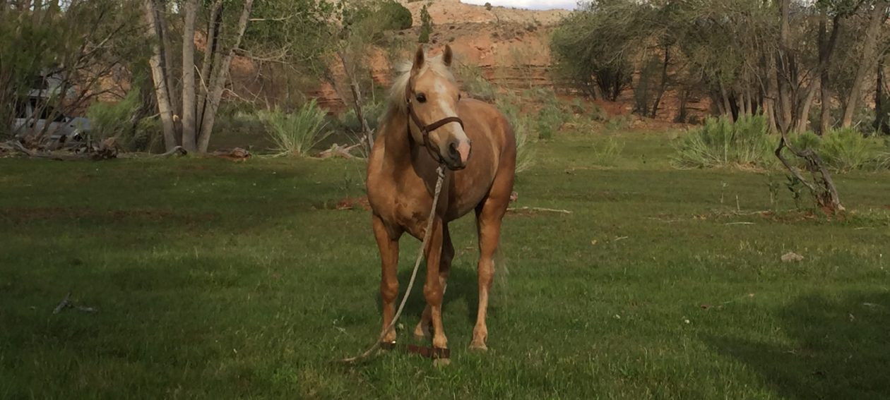


You must be logged in to post a comment.