Tag Archives: Utah

I am about to become politically involved…..

I have been following, although somewhat casually, the issues regarding land control and use in the State of Utah, which includes the recently created Bears Ears National Monument. I have read blog and facebook posts, articles, and other information shared by organizations of which I am, or have been, a member, which includes blatantly false and misleading information calculated to instill fear in the public mind that if control of federal lands is returned to the states, our treasured natural parks and other lands and resources will be forever lost and their beauty destroyed.

This evening I decided I will take an active part in this issue. On this  website, westerntrailrider.com and on my facebook page Western Trail Rider, I will be publicly supporting the efforts of the State of Utah and other states to return control of federal lands within their boundaries to the states themselves.

While I will invite and encourage educated and civil debate of those issues on this page and on my website, I will not tolerate uncivil or mean-spirited commentaries.

A cold, but enjoyable afternoon ride at Elberta, Utah…

Heading out from Salem, UT

This afternoon a friend and I took an afternoon ride to see an abandoned railroad tunnel near Elberta, Utah, a little southwest of Utah Lake. We had planned to get out there early in the afternoon, but a few complications arose and we ended up saddled and riding around 3:30pm. We decided we would start our return to the truck about 4:30pm, since it would be dark by 5:30. Besides, it was below freezing and temps would be dropping further with the fading daylight.

The trailhead, well not really a trail, but where we started our ride, is at the intersection of US Route 6 and Elberta Slant Road, several miles west of Elberta, Utah. After nearly getting stuck in the snow a number of times while trying to park the truck and trailer, we started riding north on Elberta Slant Road.

Taking the railroad bed

A short half mile or so along the road, we came across the old railroad bed. The railroad was to be a narrow-gauge, intended to service mining interests in the area, but it was never completed. The railway beds were graded, but track was never laid. This was between 2009 and 2015, after which the effort was abandoned. The failed railroad effort left , for folks who like hiking, ATV-ing, and horseback riding in the hills, a very nice network of trails through much of the area between Eureka and Elberta. We left the road and followed the railroad bed.

The tunnel

About two miles along, after a few twists and turns, while enjoying some very nice (although very cold) riding and scenery, we came to the old railway tunnel. It runs through a low hill that interrupts the climb of the railway bed through a turn. The tunnel is large enough to allow a full-size pickup to drive through it. It is not reinforced, but does not appear to be dangerous. It runs about 100 feet in length, so it does not get any darker than shadow and one is never out of sight of at least one of the entries. Still it was pretty cool.

The tunnel entrance

By the time we headed back to the truck, the light was already fading. We allowed the horses to trot much of the way back, to save time. By the time we were about halfway back, I noticed my face was stiff and I was having a hard time talking. When I raised my gloved hand to warm my face, I found my face was completely numb! I had to pull my glove off and rub my face a little to make sure I didn’t get frostbite.

By the time we got back to the truck it was full dark and we were very cold. Our feet felt like solid stumps. The horses and my dog, Clancy, though, seemed unbothered by it. We hurriedly unsaddled and loaded the horses. By the time we were halfway home we were beginning to thaw out.

Still, it was a very nice ride, one I will take again under warmer conditions.


Hmmm. I need to update the website….

I recently created a new website for a sports fan group I have belonged to for more than ten years. We are die-hard fans of everything related to Brigham Young University sports, especially football. We had been using a forum service, YUKU, for a lot of years and finally got tired of the poor service and goofy advertisements they slipped into our forum. We had to pay a fee not to see advertisements. Finally we got so fed up with it that we began to talk about looking for a new home for our forum. As we discussed it, I realized that it would be a pretty simple solution for us to buy a domain name and create our own website and forum. So, that’s what we did, using my web hosting account with Bluehost. So, I created byufans.net. It is a closed group, though, so membership is limited to the current members and those individuals who are personally invited by a member.  Sorry.

Anyway, what does that have to do with Western Trail Rider? Well, the new website looks so good and works so well and is so easy to manage that I was quite impressed with myself (hehehe). But, when I switch over to my WTR site, well, it started looking a bit drab and old. Now, every time I look at WTR I think I need to update it.

So, I’m going to be looking at new themes and other apps and programs that might sort of dress up the site and make it more user-friendly and easier to manage. Once I decide what to do, I’ll let everybody know that it may be down for a few hours…that is, if everything goes well…or a few days, if I mess up. Now, nobody need suppose that I am a website developer or otherwise expert, or even knowledgeable, about websites and blogs. I just trip along until something looks pretty good and works ok. WordPress has made things pretty simple for guys like me. It is mostly a matter of figuring out what I like, then plug-and-play. Still, I seem to be able to mess things up pretty well, as I try mixing and matching different services on the site. The challenge is going to be ensuring that I don’t lose any of the photos, information, posts, and serviceability of the current site.

Also, I understand how each provider of an app or service can spend thousands of hours developing a simple app for dummies like me to “plug-and-play” and that they certainly deserve to be paid for their efforts. However, when a guy like me starts adding up the various fees and subscriptions and donations, the cost starts to reach a significant level per year, particularly when I am not making a penny on the website.

I created the website shortly after I started planning my big horse pack trip a few years ago. A number of folks suggested that I start a blog, so they could keep up with my planning, gear purchases and reviews, and other developments, as well as documentation of the trip itself. It occurred to me that I might just as well purchase a domain name, start a website of my own, and invite other horse and trail riding folks to blog along with me. The thought was that we, together, might create a website where like-minded people might come to find information about horse trails in the western U.S. and to get first-hand information from people who had actually ridden those trails. I’m not talking about state and national park trails – there are numerous websites for those places. I’m talking about the backtrails and places that are almost unknown except to riders from the local areas. Places folks hear about, but few ever see. I figured that eventually there might be enough bloggers on the site that a little advertising income might be generated, to pay for the website maintenance. That hasn’t developed, so I’m content with simply using the site as a place to document my horse adventures for a few faithful followers to enjoy.

Still, I’d like to make it an attractive and interesting website. So, I’ll be working on updating it over the coming couple of months.

Stay tuned to see what I come up with!

P.S. The invitation is still open for anybody who would like to start their own horse-related blog under the WTR banner or to link an existing blog through WTR. The only requirement is that it be related to horse trails in the western U.S. or some aspect of horse or mule packing. There is no charge and I maintain the site at no expense to you…unless you would like to help out.  If you have interest, send me an email at tony.henrie@westerntrailrider.com.


Spanish Fork Peak Trail, Spanish Fork, Utah

Had a nice ride today with my baby sister, Crystal Barton. We started up a trail to climb Spanish Fork Peak, me on Reno and Crystal on my mustang, Jimbo. Reno, just didn’t have it in him today. He started huffing and puffing about 1/3 of the way up, and just wasn’t recovering fast enough for me, so we headed back down.

By the time we reached the truck he was doing much better, so we drove over to Diamond Fork, a little farther up Spanish Fork Canyon, and did a little riding in a little easier terrain.

Me on Reno, SF Peak in the background

Reno will need a little more work before he can make SF Peak, which surprises me, coming off our 200-mile pack trip last month. He’s young (just turned 4), so he just needs a little maturation and patient work. The trail heading up to the peak climbs several thousand feet in a matter of a few miles. It is an excellent trail for “legging up” a horse before the fall hunts, but one can easily over-do things and end up on foot. Today, turning around was the right thing to do. No sense in over-working or hurting a horse for a pleasure ride.

For those interested, the trailhead we used is up Spanish Fork Canyon (US Rte 6). Coming from Spanish Fork it is about a mile past the giant windmills. There is plenty of parking for trucks/trailers in the north side of the highway. The iron swing-gate is just west of the parking area, about 100 yards. The trail starts as a two-track, passes a fenced-in utilities installation, then heads straight up a canyon to the north. Just stay on that trail heading north and ignore anything that turns off either way. The trail heads straight up the canyon for a couple miles, then winds around the peaks and saddles and eventually arrives at the very peak. One can return on the same trail, or go over the mountain and come down Mapleton Canyon (which requires juggling vehicles and trailers for the return to the other trailhead).

Ranger and me on top of Spanish Fork Peak, 2016

The ride from Rte 6 to Mapleton Canyon parking area took us about six hours, as I recall. I forgot to take my GPS, so I can’t say exactly how far it is or what the elevation change was, but my guess is 7 or 8 miles total, end to end. Elevation change, according to maps, is about 4800′, so you are climbing at a rate of more than 1,000′ per mile. That’s a tough climb for a horse, especially when you are starting above 4700′ to begin with.

The trail is steep, but otherwise not what I consider challenging. There are a couple steep sidehills that might be a bit scary for the novice trail rider, and the occasional detour for a fallen tree, but other than that the worst of the trail is that it is quite rocky. Last year my horse made it over the trail barefoot and never got tender. I would rate it intermediate and above, for both horse and rider. Take a breast strap, and a crupper or breeching is recommended for narrow-shouldered horses.

There is a small lake or pond (depending on the time of year) just past the peak, on the way down toward Mapleton Canyon, but the water is often stagnant and filthy. Horses will drink it, but they don’t like it much. I saw no other water available when I went over the trail last year. The horses will be thirsty when you get down the mountain.

Crystal on Jimbo, climbing toward SF Peak

I recommend riding this trail the first time with someone who has been on the trail before, as the trail can be hard to find in a couple places if one doesn’t know where to look. The trail gets some foot traffic, especially during hunting season, but it is closed to all but foot or equine traffic. It sees little enough traffic that the trail is rather lightly visible in places and appears more like a deer/elk trail than a foot/horse trail, at least on the south side of the peak.

Last little note about the Spanish Fork Peak trail: The views are absolutely spectacular, once you get above the trees and break out on the west side of the mountain they are amazing. However, for most of the trail you will be in the trees and in the canyons, where the view is limited.

P.S.

I seem to have lost all the photos I took on my first ride over the Spanish Fork Trail. Sorry. I’ll get more on the next trip.

Well, here’s the plan…so far…

After making several drives and looking over our proposed route, as well as a lot of Internet research, here is what we know so far about our route and time frames for travel.

First of all, there are a couple of dates that are hard and cannot be changed. I have Backcountry Camping Permits for the Grand Canyon National Park for June 29 and 30, 2016 for four horses and two people. Those are very hard to come by, and I was very lucky to have landed it. Those dates are fixed. The second date is the Pioneer Day Parade at Panguitch, Utah. That will be on July 23, 2016. This will also coincide with the 64th class reunion of Panguitch High School’s Class of 1952, Dad’s graduating class. We cannot miss those dates.

So, with that in mind, here goes.

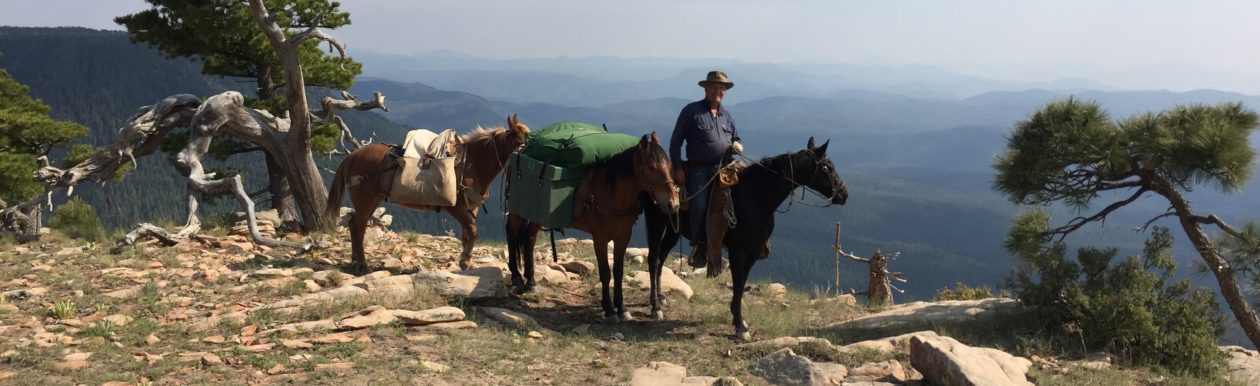
We originally planned to depart on Dad’s 82nd birthday. We had to postpone that one day, so I could see one of my grandkids…and my daughter of course., who will visit from Texas to see us off. So, we will start making tracks on Tuesday, May 24, 2016, from my pasture at 217 N. Poverty Flat Road, Eagar, AZ, 85925.  Anybody who would like to start the ride with us should be there ready to ride by about 10:00am. There is plenty of parking for trucks and trailers.

We will follow Route 260 west until we start up into the mountains, at which time we will take Forest Road 1235 north for a short ways. We will depart that road when it turns northeasterly and head directly west, cross-country. We will then join FR 117, which we will follow until we come to FR 61. We will take that to FR 96, then on to FR187, until we arrive at Sky Hi Road, Pinetop, Arizona, at the trailhead for Maverick Trail in the White Mountain Offroad Trail Association trail system.

This trailhead may be reached by taking Route 260 in Pinetop to Buck Springs Road, then north about 1/2 mile to Sky Hi Road. Turn left and follow Sky Hi north for two miles, until you come to the trailhead on the left.

We will follow the Maverick trail 50 miles to Clay Springs. We hope to be re-supplied for horse feed there by a friend from Pinetop. We will then connect with the General George Crook National Recreation Trail, which we will follow westward to join the Arizona Trail (AZT). We expect to reach the AZT by about Tuesday, June 6. We estimate 150 miles for that leg of the trip. The Mogollon Rim Road generally parallels the Crook Trail, so anybody wanting to find us may do so at a number of points along that route.

We will then follow the AZT north to Flagstaff, about 105 miles, more or less, and re-supply at the home of Gwen Kahler. We should arrive there about June 16 or so. We will probably rest there a day to have our horses re-shod and to get new health certificates for the horses (they must be current within 30 days to enter the Grand Canyon National Park). Once we hit the trail again, Gwen will ride with us for a few days. She will guide us through the area, hopefully bypassing a section of the AZT that is currently in bad shape with blow-downs. Anybody wanting to find us along that leg of the route may do so at various points where the trail intersects a number of Forest Service roads or at Mormon Lake.

The distance from Flagstaff to the South Rim of the Grand Canyon is about 108 miles. That should take us about 6-7 days of travel. Add two rest days in there and we should arrive on or about June 27. We have an equine campsite reserved at Mather Campground at the South Rim from June 25 through July 2. We hope to be able to make up a little time en route, so we can arrive on June 25, to allow ourselves and the horses some time to rest before our crossing of the “big ditch”.  We have some help who will be there to re-supply us and to keep some of our gear while we make the crossing. They will meet us on the North Rim after the crossing, to again re-supply us and get us reloaded to continue our trip.

Our crossing is scheduled for Wednesday and Thursday, June 29-30. We will descend the South Kaibab Trail about 7.4 miles and stay the first night at Bright Angel Campground. On Thursday we will cross the Colorado River and ascend the North Kaibab Trail about 14 miles to the North Rim Campground. On Friday, July 1, we will exit the Grand Canyon National Park and camp outside the park boundary. While no one will be able to cross the Grand Canyon with us, due to the camping restrictions, anyone can ride with us from Flagstaff to the South Rim or from the North Rim on northward.

We will have about another 65 miles, or thereabouts to the Arizona/Utah border, which we should make by July 5. We will cross US 89 about 34 miles east of Kanab, where the highway takes a north-south jog to cross through a hogback ridge. We should cross the highway on or about Wednesday, July 6. We will be due a rest day about then. We may be meeting several people there, who would like to ride with us for a few days, but we haven’t yet confirmed that. If they meet us there, they will re-supply us and provide water for us and the horses there.

After that, we plan to continue northward, crossing the ridge to the east and entering the Paria River drainage. We will follow that northward until we reach the entrance to a canyon on the west side that leads to Willis Creek. We will follow Willis Creek through the slot canyon and on up to the lower trail that enters Bryce Canyon. That should take us about a day and a half from US 89.

We’ll likely find a nice campsite and rest a day there at the trailhead for Willis Canyon, while we contact the Bryce Canyon National Park park service. Our hope is that we may be able to make arrangements with the park service  to allow us to enter the park from the trail at the bottom, ride the canyon, then end up at the top to exit the park.  If that works, we will leave the park, then cross the Paunsaugunt Plateau to the Losee Canyon trail and descend to Casto Road, which we will follow on in to Panguitch. The route from Willis to Panguitch should take us no more than four days, putting us in Panguitch some time around Saturday, July 16.

If we are not allowed to enter the park, we will turn south on the Grand View Trail and skirt outside the park, then ascend the plateau to Tropic Reservoir. From there we will continue as outlined above. Travel time may increase by one day, but probably not.

After having made 355 miles in 28 days last year, this seems pretty optimistic. However, if we deduct the rest days and the days we were delayed at Safford, we averaged about 17 miles per day. My estimates put our total mileage this year at about 620 miles.  At 17 miles per day, that puts our travel days for this trip at about 36, not including rest days. That includes a “fudge-factor” of 25% for those portions of the route that are not on the AZT. The AZT is, in fact, measured and marked, so there is no guesswork for that portion. We will be on the AZT for exactly 320.5 miles. I estimate the route from Eagar to the AZT at about 150 miles, and the portion from the Arizona/Utah border to Panguitch at about 85, before fudge factors. If my estimates are correct, and if we average 15 miles per day, with two rest days per week, we should have about 60 days on the trail, putting us at Panguitch on about July 23. That estimate is the long estimate. The short estimate has us arriving the week before, on or about July 16. Hopefully, the reality will fall somewhere in the middle.

We’ll see how it goes. The dates shown above, with the exception of the fixed dates mentioned, are our travel goals. While we have planned for 15 miles per day with two rest days per week, we can make up time by increasing our mileage and by eliminating some mid-week rest days, as necessary. Our only concern is that the mileage for the first two legs of the trip, from Eagar to the AZT may be underestimated. If we find that to be the case, we will increase our daily mileage to ensure we make our dates at the Grand Canyon. We will have plenty of time to  slow down and take it easy after that.

So, there it is. That’s the plan.

Again, the invitation is there for anybody who would like to ride with us for any amount of time. If it is just a day or two, you can simply show up and ride with us. We will be able to accommodate your sleeping bag, food, and clothing on our pack horses. If you wish to stay with us for longer than two days, however, you’ll have to bring your own pack animal and provisions.

You can keep track of our progress, just like last year, on the live map. Just click on the “Map” link on the main menu of westerntrailrider.com and it will come up. The map will constantly update, so it will show where we are in “real-time”. I’ll also be posting updates almost daily from my DeLorme InReach Explorer, via satellite, to my facebook personal account and Western Trail Rider page.

My cell phone number is 540-422-1990. You can call or text me, but most of the time we won’t have signal (smile).

See you around!


Ride to Swinging Bridge, along the San Rafael River, southern Utah

Two weeks ago I was invited along with Jon Tanner and Casey & Erin Johnson to head down to the San Rafael River for a ride. The area we went to is commonly known as Swinging Bridge, named for the old wooden suspension bridge that used to carry the road traffic across the bridge. I thought crossing that bridge might be a good training exercise for my horses. We will have to cross a swinging bridge in the bottom of the Grand Canyon at the end of June on our big pack trip and I sure would hate to get there and have the horses balk.

The route from the Utah Valley (Orem/Provo/Spanish Fork) area is to take US Route 6 to Price, then State Route 10 about 29 miles south to USFS 401 (also known as Green River Cutoff Road), which is a well-maintained dirt road, just north of Castle Dale. If you hit Castle Dale, you missed the turnoff. Turn left (east) on USFS 401 and follow it about 16 miles, to USFS 332 (also known as Buckhorn Draw Road). You will pass two major intersections and USFS 332 on the north side before you get to the 332 on the south side, so just make sure you stay on 401 until you see the sign for USFS 332 on the south side of 401. Take USFS 332 south about 10 or so miles further, until you pass the old bridge over the San Rafael River. There is designated (primitive) camping in that area, but you can go on another 1/2 mile and make a right (west) and go about 3/4 of a mile and you will find another designated camp area with a half-decent corral.

At the equine camp area near Swinging Bridge

There is no water at the camp area and no facilities. The river is easy to access and close enough to water horses.

The trailhead leads directly off from there, westward, up the “Little Grand Canyon”. It’s best to go with someone who’s been there before, because in some places the trail has seen insufficient use to be clearly marked and it is not maintained. Some parts of this trail are pretty spooky for horses and riders unused to the rough country, however a decent trail horse can negotiate even the toughest parts safely. I personally do not recommend this trail for people and horses that have not done a bit of back country riding. It is not a “walk in the park,” so to speak. The trail we rode goes up the canyon a ways, then turns off into a side canyon to the south that dead-ends at Virgin Spring. The spring is a pool of clear, cool water larger than your average swimming pool. A nice place for lunch.

Virgin Spring
Virgin Spring

You can also continue to follow the river and main canyon on northwesterly, on up to Fuller Bottoms. I’m told it’s about another eight or so miles. It would be a great ride if you had someone to pick you up on the other end.

Just a note about the trail: There is quicksand in the river bottom and in some other places where water occasionally stands. Be careful and pay attention to your horse. Many of them have a sense about quicksand and can keep you and themselves out of a world of trouble. Stay to areas where other animals cross, such as cows, horses, and mules.

We rode in on Saturday morning with our group along with a group of mule riders. We crossed paths with a number of hikers and backpackers, so be aware and please be courteous. Leashes are not required on dogs. It is an excellent trail on which to have your canine trail companions along.

Reno in his first packing training experience

On this particular trail, I decided to train my new young gelding to pack. He’d never had a packsaddle on, as far as I know, and I’m sure he’d never before encountered hard paniers. I put my newly acquired TrailMax bear-resistant hard paniers on him and dropped a 50# sack of feed in each side. When we started down the trail we were dead last in the group – on purpose. We had us a pretty good little rodeo there for a few minutes as Reno and Ranger got used to the sounds and feel of the hard paniers. After about a quarter mile they began to settle down enough for me to handle them. Reno, scared of the paniers and experiencing packing for the first time, kept wanting to come up alongside me. I was afraid he would end up pushing Ranger and me off the trail and down the mountainside. After a few good whacks on the nose with his lead rope he finally recognized the wisdom in staying back and following behind.

The easy part of the trail

The trail turned out to be an excellent training experience for my pack horse, however, had I known beforehand what we faced, I wouldn’t have packed him or ponied him along. We passed through willow thickets, standing rocks, narrow trails on cliff faces, river crossings, very steep ascents and descents, and even quicksand in the river bottom. By the time we finished our ride for the day, about 16 miles in and out, he had learned about walking around things, rather than trying to bull through everything. One thing is sure, he proved to be a very sound and level-headed horse. Even when he got “pinched” between a couple rocks, after trying to get through a couple times, he stood still while I unbuckled straps on one side, so I could lift the panier over a rock. As I did so, he calmly walked on forward to get through, then allowed me to re-rig the panier.  I was very pleased with him.

Due to the fact that I had one hand on the reins controlling Ranger, and one hand on the lead rope handling Reno, I was unable to get more than just a few photos and no video at all. Sorry. I’ll get some next time.

All-in-all, it was a great ride and one I plan to do again.

Tune-up ride to the Moab, Utah area last month…

Last month Dad and I took a trip down to the Moab, Utah area for a tune-up ride, in preparation for the second leg of our Mexico-to-Canada trip this year. We loaded all four of my horses, three of which will be used on the trip, and hauled from my place in Salem, Utah to Moab. The drive down took us about four hours.

The trip from Salem to Moab is actually an enjoyable drive, for the most part, coming up Spanish Fork Canyon, over Soldier Summit, down Price Canyon, then across some of the most barren desert country in the United States. Once you start heading into the Moab area, though, the scenery becomes spectacular, filled with red sandstone cliffs. You can even see from the highway several prominent natural arches off to the east in Arches National Park.

Blew a trailer tire
Blew a trailer tire

About 20 or so miles north of Moab, we blew a tire on the trailer. Luckily it was right before a nice pullout, where we changed the tire to the spare and limped on into Moab. We bought a couple new trailer tires at Chip’s Grand Tire Pros and they had us back on the road in a jiffy.

We traveled on south of Moab to about five miles, to a 4WD designated trail named “Back of the Rocks”. It is located on the north side of highway 191, south of Moab, just as the highway goes up the hill and turns westerly. There is a sign at the road entrance, but it’s not much. If you get to the Kane Springs area you have gone too far. Sorry I didn’t get a mile marker number.

This trail runs northward up on top of the cliff you passed as you drove south out of Moab. It is an easy ride that even a novice can handle, however there are some pretty spectacular views from up there. The trail runs about 2.5 miles or so and ends, so it’s a ride in and out on the same trail in a couple hours. Keep in mind that it is a multi-use trail, so you can expect to pass a number of off-road vehicles, hikers, bikers, and equines on your way.

Here are a few pictures from Back of the Rocks:

After riding Back of the Rocks, we loaded back up and headed on south about another 30 miles to Lisbon Valley.  We set up camp behind a big red rock my nephews call Turtle Rock. It is located on the east side of Highway 191 at about mile marker 197.25. There is a gate there and a ranch road that leads over behind the rock, where there are corrals. There is no water, so you have to haul your own. Good campsite, though.

The following morning we rode back into the red canyons north and east of camp. I decided to ride my new horse, Reno, who is young and needs some training. Dad rode Jimbo, our mustang. About 3/4 of a mile northeast, down into the dry wash area north of camp, we discovered a cattle watering trough with plenty of fresh, clean water for the horses. From there we made our own trails, as we explored the canyons and hills. We followed one canyon to its end, where we found a little water for the horses. We stopped there to have lunch and rest ourselves and the horses a bit. Later, we followed up a canyon with a creek in the bottom until we figured we had better start back to camp. We did 8.3 miles that day, according to my GPS.

The following day, we headed eastward to explore. It was a little easier riding than the canyons northward. We found a natural arch and climbed our horses up on top of a big, round, sandstone rock. We had an enjoyable day, Dad and I. We wandered around for several hours, putting the horses through a little training, going up and down ledges, over trees, through gulleys, and generally giving them a good workout.

On the way back toward camp, while walking through a dry river bottom with little vegetation and nothing to be concerned about, Ranger, who was ridden by Dad, stepped into a prairie dog hole and sunk up above his knee. He tried to catch himself with his other front, but it too sank, as the fine red sand simply gave way beneath him. Ranger went down onto his forehead, rolling Dad off onto the ground from nearly ground level. Ranger then went on over onto his back, then quickly got back to his feet. Lizzy got excited and began to buck. First time she’s ever bucked with me. She didn’t really have her heart in it, so I rode her out and she calmed down after a short romp. Dad was ok and Ranger was standing head down with his bridle headstall pulled down over his eyes. After a quick check to make sure we still had all our gear and body parts, we remounted and continued our ride.

Here are some pics of the second and third days of riding:

Back at camp we picked up the other two horses and ponied them out to the water trough. We then rode them over to the highway, where there is a large culvert that allows livestock to pass under the highway. I figured this was a good training exercise for the horses. We will have to pass through a narrow tunnel in the bottom of the Grand Canyon on the South Kaibab trail, so I wanted the horses to have at least a little experience with tunnels. The culvert was about 12 feet in diameter and ran for probably 200 feet or so. After a little convincing the first time through, the horses slowly got accustomed to the sounds and darkness. We took them through the tunnel several times until they no longer hesitated, before returning to camp.

We then broke camp and headed home, arriving in the late afternoon, concluding a great couple days of riding and training.


Red Mountain Trail, St. George, Utah

After a great day of riding into the southern part of Zion National Park, near Hurricane, Utah, I spent the following day, Saturday, with Jon Tanner, Michael George, Craig Sorensen, and a number of members of the Missouri Fox Trotting Horse Breed Association riding Red Mountain Trail, just northwest of St. George, Utah.

Parking area at Red Mountain Trail head

This trailhead is located just north of mile marker 15 on Highway 18. There is a very nice parking area with a restroom, which was built by the local Back Country Horsemen Association a few years ago, with the cooperation of the Bureau of Land Management. The parking lot was built to accommodate horse trailers and allows even large trailers room to park and maneuver in the lot. There is no running water and no electrical service, so you’ll need to consider that if you’re hauling horses from any distance to this trailhead. There are no parking fees, but I’m not sure if overnight camping is allowed. You’d have to check that with the local BLM office.

Once we got everyone together, we had about 31 riders, most mounted on Fox Trotters. There were at least two other groups, smaller than ours, starting on the trails at about the same time. There are several trails and plenty of room for all and we never bumped into any of the other groups while on the ride. The Red Mountain Trail makes a loop of about 6.7 miles, starting at one end of the parking area and ending at the other, so you can pick which direction you want to go. There are steel gates at either entrance, built to allow hikers, bicyclers, and horses, but not ATVs. As this area is actually outside the Snow Canyon State Park, dogs are allowed on the trails off-leash.

2015-02-21 10.41.48We headed out the south end of the parking area and got just outside the gate and waited while we gathered our forces. Once we got started, the group quickly separated into several smaller groups, all traveling the same direction. With a group of gaited horses, such as Fox Trotters, there are those who travel quite a bit faster than others, so those who wished to slow down a bit, and stay out of the dust trail, hung back a bit.

The terrain, for the most part, consists of very fine sandstone dust, juniper trees, manzanita, and sage. There are several parts of the trail that are pretty rocky, and a couple places that might present a challenge to the uninitiated rider,  but I would consider the trail to be in the category of fairly easy overall. Many of our horses, including mine, were barefoot and handled it very well.

About half-way through the trail loop, one suddenly comes upon the northern rim of Snow Canyon, which drops away about 1,400 feet in sheer cliffs from the trail. There are no walking paths and no guardrails, so one has to pay attention to things when going up to the edge for a look or for photos.

Snow Canyon, St George, Utah

What one sees here is breathtaking and cannot be adequately captured on my little iphone 6 camera. I did my best, but this is a sight one must take a look at in person to really experience it.

We broke there for lunch and sat around enjoying stories from some of the more experienced riders in the group, which was enjoyable all in itself. This area is primitive, so don’t expect any picnic tables or trash cans.

After a restful half-hour or so, we mounted up and headed out to finish the loop. The entire ride took under 3 hours, covered 6.7 miles, and was quite easy on the horses and riders. On the way out, there are at least two trails that diverge from the main, so one must pay attention to make sure he/she is tracking where they want to go. The trail markers were not entirely clear as to which way was back to the parking area. Having someone along who actually knows the trail is nice, but not absolutely necessary, as one would have to try pretty hard to get lost. Just keep tracking east and eventually you’ll hit the power lines and Highway 18. Then just look around and you will be able to find your way back to the parking area, since the area is almost clear of trees for at least a hundred yards from the highway.

2015-02-21 12.04.25This was a short ride and would make a good “filler” ride for some extra time during a weekend trip to the area. There are a number of other similar trails in the area, so one could actually fill up a weekend, and more, hitting them in turn. Each trail around the Snow Canyon area holds its own particular spectacular views and adventures.


Enjoy the photo gallery.

Coal Pits Wash Trail, Hurricane, Utah

Several weeks ago, I was invited by Jon Tanner to fill a slot in his trailer for a ride down to the Saint George area of southern Utah for a couple days. He was going down to meet members of the local Missouri Fox Trotting Horse Breed Association for a couple days of riding. After he twisted my arm a while, I agreed (that’s exactly how it happened, right Jon?).

Jon picked up me and my horse, Ranger, Friday morning at 6:30am and we headed south. We arrived at the designated meeting site, the Washington County Equestrian Center at Hurricane, Utah at about 10:30am. I was surprised to see that about 30 riders showed up. I had no idea there would be that many. Due to the large size of the group, and that some wanted to see one area while others wanted to see another, the group split for the day’s ride.

Jon and I followed Janet Carver to the Coal Pits Wash trailhead, located about 8 miles and a bit east of Hurricane on Highway 9. The parking area is a wide spot on the north side of the road just before the highway turns a bit north. I don’t recall seeing a road sign announcing the location, so you just have to look for it. The parking area will hold several trucks and 4-horse trailers and there is room for a turn-around, if necessary.

Parking at the trailhead

The trailhead is easy to see. There is a gate that marks the trail. Once through the gate (make sure you close it after passing through) the trail is easy to follow. It tracks generally northward. Just a short distance up the trail, you will cross into Zion National Park. Although there are only trail markers where different trails intersect, it’s not terribly difficult to see where others have gone before. In some areas, where the trails my diverge or where the rocky ground sort of hides the trail, you will find rocks stacked to mark the trail. Also, this trail is open to horse,  bicycle, and foot traffic, so be aware of other travelers and be courteous to all.

Heading north from the trailhead

The trail heads north into a broad canyon where the traveling is fairly easy. The trail has a slow, steady climb, crosses through the creek several times, but more often stays up on the bench on the east side of the creek. It is a good idea to water your horses in the creek, as once you start your climb up out of the wash, there is likely to be little water on the trail.

There are several deep cuts in the bench, from erosion, that one must either go around or cross through. Which you choose to do is up to you and your horse; a couple of the cuts were pretty steep and narrow. In fact, coming back we simply jumped a couple of them, rather than taking the long way around. This is an area in which an inexperienced rider and/or horse can get themselves into trouble, so don’t bite off more than you can chew, so to speak.

Climbing the Coggins Trail

On up the trail about two miles, you will come to the intersection of the Coggins Trail. This trail leads up a steep switch-back that climbs very quickly up out of Coal Pits Wash and up through a saddle. This trail, while not particularly challenging for the average horse, may be quite intimidating for the uninitiated rider. The climb is steep and the slope falls steeply away from the narrow trail. As you climb higher on the hillside, you will find some pretty spectacular views of the area you have just passed through. If you will click on the photo below and enlarge it, you will see a string of riders from our group about three-quarters of the way up the hillside.

The climb up out of Coal Pits Wash on the Coggins Trail.

The trail then goes over a saddle into some fairly level and easy-riding areas that track generally east-by-northeast through juniper and pinon trees toward beautiful red and white cliffs. At this point you are above the wash and will find little water, other than the occasional puddle left over from recent rains.

2015-02-20 14.52.53At this point we tracked generally toward the cliffs, following a well-marked trail – marked by traffic, rather than signs – until we felt we had gone far enough and turned around. We found2015-02-20 15.17.34

a small, sort of mini-slot canyon off to one side of the trail that we followed up a ways. It added interest to the ride, but was just a short diversion that required either a return trip the same way we entered, or a little bushwhacking to make our own way over the ridge back to the trail. We chose the bushwacking.

2015-02-20 15.23.04Also, along the way up on top, keep your eyes open for petrified wood, such as the log laying across the trail in the photo to the left. I’m told there are dinosaur tracks somewhere in the area, but we didn’t take the time to look for them. I’m sure you could get more information as to where they are located from park rangers (we didn’t see any rangers during our ride).

We followed the same path out that we followed in, however one has to pay attention, as there are several trails that diverge from the main trail. As mentioned, there are trail markers at points were marked trails diverge from the main, however, sometimes it is difficult to determine where the trails actually diverge. At one point we missed a turn and went several hundred yards on the wrong trail before we realized we didn’t recognize the terrain. We simply went back to the last marker and found the trails diverged on a large, flat rock and we simply missed the trail. Once we recognized our mistake it was easy to see the small stack of rocks that marked the trail we wanted.

2015-02-20 16.29.21Although we traveled out on the same trail we followed in, the views were as spectacular as before. Each direction offers its own views and perspectives and there is nothing lost in following the same trail out.

Our ride took about four hours and covered around seven miles. It was an excellent way to spend a nice February afternoon. By the way, the temperatures were in the high-sixties, with clear blue skies for us. In the summertime you can expect temperatures above 100 degrees. Wintertime is the time to see this area by horseback.

Enjoy the photo gallery.