During February, 2024, my good friend, Derek Habel, and I made a trip into Arizona for a ride in the Blue Range Primitive Area, in southeastern Arizona. “The Blue” as the area is known locally, is one of my favorite places in all the world. It is essentially a low mountain range split by the drainage of the Blue River, which runs south into a confluence with the San Francisco River. In 1905 Forest Service Employee W.H.B. Kent described the Blue Range as “no discernible mountain range, but rather a chaotic mass of very precipitous hills” (USFS website). It is an apt description. The Arizona side is a designated Primitive Area, while portions in New Mexico are designated Wilderness Areas, according to the Apache-Sitgreaves USFS website. It was the last primitive area designated in the U.S. National Forest system.
When I was a young 15 years old, I was introduced to “The Blue” by my father, who took my younger brother and I on our first real deer hunt with horses. He drove us down the dirt road known as Red Hill Road, to a particularly wide spot about 3/4 of the way to the bottom, where we made our camp and stayed a few days. During that short stay, I grew to love that area and it has had a lasting impact on my life.
In about 1990 or so, I took my son, my sister, and her boys on a backpack trip into the area known as Tut Creek. We hiked up a trail to a saddle just north of Foote Creek Mesa, where we made camp. The following morning, we hiked about a mile to Cleveland Spring, which was nothing more than a short pipe sticking out from under a rock, where we filled out canteens. From that day, I have wished to ride Cleveland Spring Trail from Tut Creek to Foote Creek.
So, with my riding buddy, Derek, I finally checked off that bucket list box .
The trailhead from which we started is the Tut Creek Trailhead. Getting there is pretty simple, but not without some adventure. Take US 191 south from Alpine, Arizona about 14.2 miles (You can come up from the Safford area, but this highway was once designated US 666 and is definitely not recommended for pulling a trailer longer than about 25 feet) then turn east on Red Hill Road.
Red Hill road, is a regularly maintained dirt road that winds down fairly steeply into the Blue. Near the bottom. I say “regularly maintained” however, that is rather subjective. It gets graded now and again. Don’t try it when it’s been raining. You may not make it. Follow that road downhill somewhere around 15-ish miles and you’ll pass the trailhead on the west side of the road. It’s about a quarter-mile from the Blue River crossing, so if you get to the river, you passed it.
Now, you can also get there by taking Blue Road, which heads south from US 180 just east of Alpine, Arizona. This road is a much better road, still dirt, but maintained more often, and less steep than Red Hill Road. When you reach Blue Crossing after about 22 miles, where Red Hill Road intersects Blue Road, turn north on Red Hill Road, cross the Blue River, and head up about a quarter mile and you should see a sign indicating the turnoff on the two-track to the trailhead. If you are towing a horse trailer, look to the east side of Red Hill Road and find a place where you can pull off and park. Dispersed camping is allowed, with the standard 14-day stay limit.
So, that settled, head west on the two-track about a half mile and you will find the official trailhead (coordinates: 33.63125, -109.1098). Third warning: Don’t try taking your trailer in there.
There you will find the trailhead signage, indicating it is designated for foot and equine travel; no mechanized vehicles.
Follow the trail until you cross Bush Creek. Somewhere along there you will find a trail sign indicating the various trails you can take from there. If you go right, you can take Red Hill Trail, which will take you to the top of the Blue Drainage, to a trailhead you would would have passed on the way in on Red Hill Road. If you go straight west, as we did, you will be on Cleveland Springs Trail.
Cleveland Springs Trail will take you up a lower canyon for about a mile or so, then abruptly turn up a side hill on a switchback to the south. As you climb the side hill, the trail will eventually sweep back toward the west to take you across a saddle on the north end of Foot Creek Mesa. There are a number of nice camp areas on that saddle and it is the place where I camped with my sister, her sons, and my son those many years ago.
Continue on westward on the trail, through a fence gap and you will begin your descent into Foot Creek. This trail is a bit sketchy, as there has been no maintenance of it in probably the past 50 years, but if you keep your eyes peeled, you can find your way across and down the mountainside to the creek.
(Click on a photo to get full-size)
Derek and Ace, Lower Foote Creek Trail
Once at Foot Creek, you will see the trail intersection at a fence gap. If you turn right, or north, through the gap, you will begin the ascent to the top of Foot Creek Trail. If you turn to the left, or south, following the creek as we did, you will descend to the Blue River, however, the trail is not well marked once you leave the creek bottom. We must have made a wrong turn once we got into the meadows at the bottom, because we had to do a bit of bushwhacking to get up to Blue Road.
From there, we followed Blue Road eastward until we got back to Blue Crossing, turned north onto Red Hill Road, crossed the Blue River, and returned to our point of origin. The ride comprised a loop of about 6.5 miles and took us most of about 6 hours. Now, we were riding gaited horses, but there are mighty few places on that ride where one would be able to gait along at a decent pace. With the ups and downs, and switchbacks, and bushwhacking, I guess about 1 mile per hour was about right.
Here’s a compilation of some videos we took on the ride (or see my YouTube channel at Western Trail Rider).
Since the Wallow Fire of 2011, many of the trails in The Blue, such as Foot Creek Trail, KP Mesa Trail, Grant Creek Trail, and Steeple Creek Trail, all of which were once nationally know trails, have nearly disappeared. I have been told Grant Creek Trail is impassable, but I have made it all the way down. I was told Red Hill Trail is impassable, but I and a couple friends made it all the way from the bottom to the top. I have been told Foot Creek Trail is impassable, as well, and it may be, above Cleveland Springs Trail, but we were able to make it from there to the Blue. I guess a lot depends on how badly you want to get from one place to another and how much faith you have in your horses.
For me, as I said before, this was a bucket-list ride I had been wanting to do for nearly 35 years and I enjoyed every minute of it. While the trail has not been maintained in many years, the wildlife and cattle use it, as do the cowboys who still run cattle in the area, but it sees very little travel from visitors. There are places on most of the trails where one really has to hunt around to find the old trail, but if you know what to look for, it can be found.
One day, if life lets me, I would love to spend a couple summers riding up and down all those trails and restore and re-mark them all, so hikers and horse riders can once again enjoy my favorite place in all the world.
I guess an apology is meaningless here, so I won’t bother. It’s been more than 3 years since my 2019 moose hunt trip to Alaska with Derek Habel and I’m just now getting around to finishing the story. This is my sixth post about it, I believe.
So, when I left off, I had just gone off with a saddle horse and four pack horses to return to the trailhead, 19.97 miles by our gps, to pick up about 440 lbs of horse feed to bring back to our camp. I documented that whole experience in a previous post (somehow I got things a little out of order as I was documenting the trip), so I won’t go back over that trail here. Suffice to say that it was a tough ride, particularly coming back in with four pack horses, fully loaded, alone, in grizzly country. However, having said that, a hot shower and a warm, comfortable bed at the trailer made it the trip almost worth the trouble!
We’ll pick things back up as I was arriving back at camp, Tuesday evening, after a very long and hard day on the trail. I arrived around 7pm and Derek had gotten back into camp just a little before I got there. He had a roaring fire going. We both pitched in to unload and care for the horses, and it wasn’t long before dinner was ready. It felt very good to sit and warm myself by the fire. My feet were soaked and cold from the river crossings coming in and I was utterly exhausted. If you haven’t read it, go back and read post #4, which I linked above, about my trip to bring feed for the horses back in. On the trip back in to the camp, I had three wrecks with my pack string, two of which were pretty serious. I was lucky that neither I nor any of the horses was seriously injured. It’s really too bad that I had nobody to get video footage of that ride. It was a tough one.
Not dead, just resting.
On Wednesday morning, that would be September 18, 2019, Derek and I packed up two saddle horses and all four pack horses and headed back into the back country. We traversed the low bogs, crossed Iverson canyon, made our way up Anaconda Creek, over to Cottonwood Creek, and finally down into Carden Creek, where we found a cozy little spot for a camp. All told, we were about 12 miles from our base camp. It was some pretty tough riding, but as we had come that way the previous week, we had idea of the easiest routes to take and kept the horses out of most of the toughest bogs and thickets.
The following day, we saddled Moose and Finn and headed out to hunt. We found a nice knoll above Carden Creek, from which to scope the area, but saw nothing we could hunt. We spotted a couple bull moose down farther in the valley, but they were too far off and moving too fast for us to make a try at them. They probably had been spooked by hunters brought in by the local outfitter.
On our way back toward camp, Derek spotted a cow moose and calf on the hillside opposite the one we were on, across Carden Creek. We stopped and watched for a few minutes, before we saw a second cow and decided that there was probably a bull somewhere nearby. After about a half hour or so of scoping the hillside, we finally saw him. He was a legal sized bull, but not a trophy.
I need to interject something here, just for background information. A couple of Derek’s friends, resident hunters of Alaska, had flown in and met us at our base camp the previous week and we hauled them up into the foothills east of camp to get them started on a Dall sheep hunt. As they were Alaska residents, they were hopeful that they might also get a chance at a Grizzly bear after their sheep hunt. Derek only hunts for trophy moose, so there was no guarantee that he would take one, but I, on the other hand, had no such aspirations. Derek’s friend purchased a bull moose tag for me in hopes that I might score a bull and create a “gut-pile” to attract a Grizzly to the area. With that in mind, Derek set me up to take the bull we were looking at from that hillside on Carden Creek.
The bull was laying near the base of a tree, which is why it took us awhile to see him, facing north and broadside to us. After using Derek’s range finder, we determined that the range was 440 yards. I carried our bear protection rifle – a .457 Marlin lever action, so Derek gave me his custom 300 Ultra Mag with an excellent range-finding scope. He coached me through the use of the scope to get the proper rise and I got myself into a comfortable seated position. I held a long breath, slowly exhaled, and squeezed her off. I saw the bull toss his head and thought I had hit him, but he didn’t do anything else, so I took a second shot, which I was pretty sure hit the mark. He then stood up. I took a third shot, which I thought scored as well, but he then slowly turned away from us and started to slip behind some brush. I took a fourth shot, which I was pretty sure missed completely. He slipped behind the brush and out of our sight. I was pretty sure my second shot was a solid hit, so I mounted up on Moose and started to find my way down the mountainside, across Carden Creek, and up the opposite mountainside. Derek remained at the site from which I shot, to spot for me and make sure I found the moose.
It took me close to half an hour to reach the bull, but I found him not 20 feet from where I first saw him laying near the base of the tree. He was dead as a hammer. As it turned out, my first shot hit him in one of his antlers. After he stood up, my next two shots were both in the neck and were both kill shots. As I had thought, the fourth shot missed completely.
Derek and I got to work cutting up the moose. We quartered him and pulled the backstraps and left the meat laying on some moss to cool, while we went back to our satellite camp and returned with our pack horses. By the time we got the meat and antlers packed on the horses and made our way back to camp, we were a couple of tired puppies.
The sky was lowering that night, so we prepared our camp for rain. It came in the early hours of the morning, which made getting up and getting packed up for our move back to base camp a cold, wet, chore, but we were on the trail by about 7:30am.The trip back to base camp was a rough one. Neither Derek nor I had slept well and we were exhausted. Our horse feed had run out the day before (what we brought out with us from base camp) so the horses were hungry and irritable, as well. Missy had a sore back, so she was problematic for us and she kept getting us all tangled up in the pack string. She became such a problem to us and all the horses that we considered more than once just shooting her and having it done with! However, our better selves prevailed and eventually we got things sorted out to minimize our horse problems and made our way back toward base camp….in the rain.
We were supposed to be meeting Dave and Zack, our intrepid Dall sheep hunters, somewhere along the path back, but we had no communication from them and gave up trying to contact them by satellite and cell phone (it was amazing that we had cellular coverage in some areas). When we arrived back at base camp that afternoon, it was like coming home…almost.
My horse, Apollo, as I mentioned in previous posts, had developed a limp on his front right foot on the trip in from the trailhead. I had him shod by a farrier I had not used before a couple days before we left Spanish Fork and I think the farrier quicked him. Apollo lost the shoe on that hoof before we had been out three days, but I was lucky enough to have been able to find the shoe and retrieve it. I re-set the shoe and hoped that would relieve the pain in his hoof. I also gave him some rest the first week, but as time went on we had to have him. During our three-day hunting expedition to the Carden Creek area, Apollo again lost that same shoe. I didn’t bring our farrier kit with us, so he had to go barefoot on that hoof. He was fine in the tundra, but while crossing the rocky creek beds, he was very sore. I took it as easy on him as I could. He was game and kept on working. Once we got back to base camp I again re-set that shoe.
During the whole trip, I had to re-set seven horse shoes. I went through all the spares we brought and finally ended up having to make a rear shoe out of a used front shoe to get us out on the last day. It held, though. We haven’t used that farrier since.
All the horses, at this stage of the hunt, were showing wear. Apollo and Missy were dropping weight quickly and were looking pretty thin. The rest of the horses had rub sores in one place or another from the pack saddles. I was double-padding Missy, to ease her sore back. Having said that, all-in-all, we and the horses were in pretty good shape for the work we were doing. We had plenty of feed for the horses at base camp, so they were well fed when we were there. The dogs, Ruger and Lucky, were ok, although Lucky was still suffering badly from the porcupine quills in his mouth (I talked about that encounter in a previous post). We continued to pull one or two now and again, whenever we saw the opportunity, but Lucky was not wanting anything to do with us by that time.
The following day, Saturday, September 21, Derek and I saddled up and packed up the horses and headed back out toward Carden Creek and farther south. We blazed a trail through the tundra and thickets, cutting out a bunch of scrub trees and clearing a trail for ourselves, made our way past Cottonwood Creek and made our way over to our previous satellite camp. We set up camp for the night there and rested that evening.
On Sunday, we headed over the hills south of Carden Creek, up on to a rise, then down into a valley. As we continued southward, we sighted a decent bull on a hillside a half-mile or so away. We headed that direction. When we got close enough, Derek started a stalk, while I took the horses around to an area where I thought we could approach without being seen. While I was bushwhacking, Derek was able to stalk to within about 200 yards and scored a very nice bull with a one-shot kill.
As I made my way toward Derek’s kill, the remaining moose, several cows and another nice bull, passed right by me and the horses. In trying to find a way to reach Derek’s bull, I ended up in a gully about 100 yards or so below where I needed to be. I could see no easy way to get there, so I pointed Ginger up an extremely steep, brush covered, hillside, making our way in short switch-backs, up the side hill. Finn, on the other hand, wouldn’t follow us. I ended up dismounting and just letting Ginger head on up the hill on her own (Derek was waiting at the top of the ascent), while I went back for Finn. I finally succeeded in coaxing Finn up the hill, now that Ginger was at the top, and we both reached the top of the hill out of breath, but in good shape.
We again quartered the bull and caped this one (it was a very nice 64″ bull), but having no pack horses, we laid out the quarters and backstraps on the moss to cool, and headed back to camp. We picked up the other horses at our satellite camp and continued on toward base camp. We had made contact with Dave and Zack and had made arrangements to pick them up in Anaconda Gulch around 2pm, but we didn’t reach them until about 6-7pm. It was long after dark after a very long day when we reached base camp that night.
Dave and Zack had spent 12 days in the high peaks hunting Dall sheep. They had scored a nice buck with full curls, but had no further luck. They had eventually run out of food and had been living on fresh mutton without salt for a couple days! They were happy to see us.
We had a fun evening that night, exchanging hunt stories with Dave and Zack. We stayed up past 2am, before running out of steam and heading for bed.
On Monday morning, two planes came in and landed in the river bed, not far from our base camp, to pick up Dave and Zack. Derek and I again packed up the horses and headed back over to our Carden Creek camp. We had previously cleared a lot of the trail, which made the going easier, but by the time we arrived at camp that evening, we were bushed. We had a quick meal and went to bed.
The next day we packed up early and, with all the horses in tow, headed over the hills to retrieve Derek’s bull. We had it loaded and underway by around noon. We arrived back at our base camp in the early evening, before dark, after having made 23 miles on the day.
The following morning we arose early. I went right to work replacing a hind shoe on Apollo, which he had lost the day before. I was out of shoes and almost out of nails, having replaced six other shoes during the trip. I took the front shoe Apollo had lost days before and used a rock as an anvil and another rock as a hammer, and was able to rough it into shape as a rear shoe. I tacked it on and while it was ugly, it held and he made it out with all four shoes in place.
We then packed up the camp, loaded up Derek’s bull, and headed back toward our trailhead and the trailer in Beaver Creek, Yukon Territory, Canada. We left my moose quarters and backstraps hanging on our meat pole. The trip out was sort of a blur. We were exhausted from our exertions of the past couple of weeks, as were the horses, but they and we knew we were headed back toward the trailer and the end of the trail. The horses moved out without any urging from us.
Coming out after a successful hunt
We had gone just a couple of miles, when we came upon a young bull and a cow crossing the river. The cow was very concerned about us and stood her ground, watching the dogs and us. She showed some aggressiveness, so we kept our distance. An angry cow moose is nothing to mess with. The bull, on the other hand, not quite legal size for hunting yet, was entirely focused on the cow. I’m not even sure he noticed us at all. The cow must have been in season, because he was completely focused on her. We waited several minutes, got a little video footage, then they moved off across the river and into the woods.
We made it to the trailer in very good time, arriving in the late afternoon around 4pm. We clocked 19.97 miles in 5 hours 27 minutes, fully loaded.
It was very nice to be back at the trailer that night. Derek’s living-quarters trailer is almost like a hotel room and a hot shower was excellent!
But, the trip was not over for me. I still had to go back for my moose!
The next morning, Derek arose at 6am and packed up Ginger and Shadow for me and saddled Moose with my gear. He let me sleep in until 7, waking me up for breakfast. I was in the saddle and headed back to the base camp by 7:37am.
The morning was wet and it was snowing lightly, and it was cold and breezy. I had dressed for it, though, so I was comfortably warm, at least until water from the river crossings started getting through to my feet. Still, I had long since gotten over the “heeby-geebies” of being alone with horses in Grizzly country, so I enjoyed the ride in. The river was higher than the previous year and many of the short-cuts and byways I had come to know from my previous trips in and out had changed, but I was getting to know the way fairly well by this time. There was little guesswork this trip and I was able to avoid the worst of the traps and log jams I encountered on the previous ride in. The horses moved along well and gave me no trouble, the weather cleared by mid-morning, and I enjoyed watching the mountains change as I drew nearer to them.
I arrived at base camp, now empty but for my moose and a few odds and ends of gear, just before 1pm. We made the 20 miles in 4 hours and 13 minutes. Happily, I found the meat on the meat pole had not been disturbed. I took about an hour to rest, eat lunch, and let the horses get what little grass was left in the area.
Then came the hard part. A quarter of moose can weigh upwards of 200 pounds, and I had the task of loading two pack horses with 4 quarters and some other large packs of meat, and some remaining camp gear, by myself. It helped that the horses were compliant and stood in place while I struggled to get each pannier up and hooked over the pack saddle trees. By the time I had both pack horses loaded, I was in a full sweat and exhausted!
Derek had given me his satellite phone for the trip, so I took a minute to call and let him know I had made it in safely and was heading back out. It was 2:02pm when I climbed back in the saddle and headed out. The trip out went smoothly. No problems from the horses. I was mounted on Ginger and she led the way at a wonderful pace. If there was five feet of level ground in front of her she stepped up into a foxtrot! Anything else was at a fast walk. As the miles flew past, I began to run out of energy. I mean, this was a tough day on a 61 year old saddle bum! By the time we rolled into camp I was just about at the end of my rope.
We arrived at 5:55pm, making my trip out, fully loaded, 3 hours and 53 minutes. Overall, we traveled 40 miles (39.94 to be exact), took an hour’s break in the middle, in 8 hours and 20 minutes…or thereabouts.
We arrived in the evening at 5:55pm, just before dark. Derek was there to welcome us in and simply waved me to the trailer while he unpacked, cared for, and fed the horses. I later calculated my travel time: Trip in – 4:13, trip out – 3:53, lunch break and packing – 1:12, total trip 9 hours 18 minutes for 40 miles.
That evening, Derek treated me to a nice meal at Buckshot Betty’s restaurant. They have hot showers and changing rooms in the back as well, so we took advantage of that too.
The next morning we were met by a Yukon Territory Conservation Officer, who nicely informed us they were waiting for us to show up at the Canadian Border Patrol Station to obtain proper permits to transport our moose meat through Canada. We stopped first at Buckshot Betty’s for a nice breakfast, then headed over. We were in full compliance with all regulations and all went well. Then we drove the 18 miles to the US Border Patrol Station to declare out kills and get the proper inspections to depart the US and enter Canada with the meat. We then stopped again at the Canadian authorities’ office, where they were already expecting us and moved us through quickly and with no trouble. We were on the road headed home by just after noon.
It was a long, but relaxed 4-day drive home. Both Derek and me, as well as our six horses, were due for a nice long rest.
I’m pretty proud of what those horses and I did on that last ride. We made a 40-mile ride through the Yukon Territory back country, without a trail, following a river with dozens of crossings, with a pack string loaded with meat and gear, with an hour break in the middle, in nine hours and 18 minutes!
That’s what a string of Missouri Fox Trotters can do for you! Not too shabby for an old man either!
For many years I have wanted to ride some of the trails in the Superstition Mountains, near Phoenix, Arizona. Being an Arizona boy myself (currently living in Utah) I am very familiar with the area and the legends of the Lost Dutchman Gold Mine, from which an entire tourism industry arose in the area known as Apache Junction.
As the legends go, way back in the late 1800s a fellow came into town with a sack of gold to deposit in a bank, but he would never tell anyone where he got it. Eventually he died and nobody ever knew where his mine was located, except that he was believed to have been mining in the mountains now known as the Superstitions. Since then, that small, but very rough mountain range has been scoured by treasure hunters to the degree that it eventually became a favorite hiking area that sees very high foot traffic throughout the year.
Being a lover of difficult and challenging trails, I have long wished for an opportunity to ride in the Superstitions. Last week (the weekend of December 29-31, 2022) I finally got my chance. My good friend and riding buddy, Derek Habel, was looking at buying a horse in the Apache Junction area. He decided that he needed to combine a trip to look at that horse with a ride or two in Arizona, where the weather was much warmer and more hospitable than here at home in Utah. So, he called me and tossed out the idea of us heading south for a few days, combining a short visit to my parents in Eagar, AZ with a trip to the valley to check out that horse he was looking at. I, of course, jumped at the chance!
We decided to take a couple of Derek’s horses, as they are trail novices and need some work to make them good trail horses. Big John is a 12 year old Missouri Fox Trotter gelding, standing about 15-3HH, weighing in at around 1200 lbs. That’s the horse you’ll see me riding. Powder is a 6 year old (I think) registered MFT gelding, standing about 15-2HH and about 1000 lbs or so. Derek rode him. Both these horses are well saddle broke and have calm dispositions, but lack a little in good bridle and trail training.
HINT: click on photos for large version
We departed the Spanish Fork, Utah area on Wednesday, December 28 amid a serious snow storm and headed for Arizona. We drove nearly 8 hours through snow, sleet, ice, fog, and rain, finally breaking out into better weather for the last three hours to my folks’ place in Eagar, AZ.
We spent one night there, then headed the following morning toward Apache Junction, which is a suburb of Phoenix, Arizona. I love that drive! It had been more than 30 years since I had driven it and I thoroughly enjoyed describing all my memories to Derek as we passed through Show Low, then the Salt River Canyon, Globe-Miami area, and down Devil’s Canyon, through Superior and on into the Valley of the Sun, by which the Phoenix area is sometimes known. Dangit! Amid all the talking, we forgot to get any photos of the drive!
We arrived at the stable where the horse Derek wanted to see was boarded at about 4pm. After evaluating this registered Missouri Fox Trotter, we were less than impressed, given the asking price, so Derek and the owner were unable to come to agreement. (Derek, being a large man, looks for large Missouri Fox Trotters that have a natural gait. I help him make them into excellent trail horses.) We grabbed a hotel room for the night and began to plan for a ride the following morning.
We decided to take the trail recommendation given us by the owner of the horse we had come to see, so we headed back toward Superior, to the Picket Post Trailhead, located about three miles west of Superior.
The Picket Post Trailhead offers several options for hiking and horseback riding. We selected the loop, which is designated as the Arizona Trail #222. This is a loop of 8.4 miles, much of which is also a section of the 700 mile long Arizona Trail, which stretches from the US/Mexico border all the way to the Utah/Arizona border.
We found the signage on the trail to be somewhat confusing, as apparently someone else did.
We followed the signs for the Arizona Trail, moving in a clockwise loop, which eventually led us through Telegraph Canyon, then along a two-track ranch road, and eventually back to a true trail bearing the Arizona Trail markers, returning to the Picket Post Trailhead. You can find our track on my page on the Ramblr ap @westerntrailrider.
The USFS has graciously provided an ample parking area at the trailhead, including an area specifically designated for trailers, however, as is usually the case, the hiker parking lot can fill up quickly on weekends, after which the trailer parking area begins to fill up. I have learned by sad experience to park with my rig pointing to the exit in such a way that nobody, not even a tiny little electric car, can park in front of me. The trailhead is a little farther off the highway than I expected. You will pass a set of corrals within sight of the highway, but this is not the trailhead. Continue on the dirt road, bearing left at the first intersection. This road will dead-end at the trailhead. There is a pit toilet at the trailhead and covered picnic tables, but no other services. Bring your own water.
The Arizona Trail #222 loop is an excellent desert trail for horseback riders and hikers. No motorized (including E-bikes) traffic is allowed on the portions which are part of the Arizona Trail (all but about a mile of the loop). You should expect to encounter numerous hikers, as this is a very popular hiking destination. This is USFS land, so dispersed primitive camping is allowed. The trail follows two streams, so water for the horses and humans (if filtered) is available most of the year. This is a fairly easy trail, however in Telegraph Canyon we found a couple places where a competent trail horse was called for. Some sites rate this trail as “moderately difficult”, but we thought that was a little higher on the difficulty chart than we would place it. The terrain is rocky, so while I would recommend shoes on horses, we rode it barefoot and our horses never got tender (If you are planning more rides in the area within a couple days, however, unshod horses will definitely get ouchy). Derek and I agreed that on a difficulty scale from 1-10, this trail was about 90% a level 2 (easy) and about 10% level 5.
One caution I will definitely mention is the cactus. There are numerous varieties of cactus in this area, including the mighty and beautiful Saguaro, prickly pear, barrel cactus, and several varieties of cholla, also known as “jumping cactus.” Cholla cactus is what you have to watch out for. It has unbelievably sharp spines, of which even the lightest touch can cause a nodule to attach itself to the victim (ergo the name “jumping cactus”). The horse and/or rider not acquainted with cholla cactus can quickly escalate a simple prick to an emergency 911 situation.
If you or your horse should brush a cholla cactus and get a nodule stuck to you or it, remove the nodule by grasping the spines with a tool, such as a multitool pliars. Grabbing the spines with your fingers usually results in the nodule sticking to your fingers in a never-ending cycle. After removing the nodule, check the area and remove any remaining spines. Infection does not normally occur unless part of the spine is left beneath the skin, like a splinter. Chaps for the riders is a good idea.
One last word about trails in the Phoenix area: These are trails best visited in the cooler months of the year. During the last weekend of 2022 the weather was damp and temperatures hovered around 60 degrees F during the day. During the summer months, this area is a veritable oven, with temperatures regularly rising above 115 degrees F. Also, during the hottest months, it is likely the streams will be dry, offering no water at all.
The following day, Saturday, December 31, 2022, Derek and I decided to give the Bluff Springs Trail – Dutchman’s Trail Loop a try. I had done a couple searches on the Internet for “Equestrian Trails Superstition Mountains Apache Junction, AZ” and come up with the Bluff Springs Trail as the #1 recommended equestrian trail in the area. The Trailhead is the Peralta Trailhead, located northeast of Apache Junction, within about a half-hour of town. The loop is about 9.6 miles long. Our trail track may be found on Ramblr.com @westerntrailrider.
The official trailhead offers inadequate parking for hiker traffic, however, just south about 100 yards or so before you arrive at the official trailhead, there is a designated RV and trailer parking area large enough for several fairly large rigs. However, as stated before, this area serves as overflow for the hiker parking. You can expect both parking areas to fill up during the weekends. There is a pit toilet at the trailhead, but no other services. There are a couple of streams that cross the trails, but I expect they will be dry much of the year. They were running quite well during our visit and offered plenty of water for our horses.
At the trailhead we found a USFS Ranger, who advised us against taking the Bluff Springs Trail on horses. He said that particular trail is “not recommended for equines”. He described some of the trail and allowed that horses are not prohibited, but the Bluff Springs Trail was not recommended for them. After talking with him for a few minutes, we decided to give it a try anyway. Derek and I are both very experienced on difficult trails and felt we are capable judges of a horse’s ability to negotiate any particular trail obstacle. We assured the ranger we would dismount and walk where necessary (and we did a couple times).
Departing the Peralta Trailhead by the regular trail, about 100 yards along, we came to a trail sign where the trail diverged in three directions.
Having read that a clockwise circuit of the loop was recommended (to put the hard climb at the beginning), we selected the Bluff Springs Trail for our start (the loop returns on the Dutchman’s Trail). The Bluff Springs Trail climbs steadily for about 1.5 miles and climbs and descends several times thereafter for another 3 miles or so. In the first 1.5 miles, we decided we agree with the USFS’s position that this trail is not recommended for equines.
That is not to say that an experienced trail horse and rider team cannot negotiate this trail, but even an experienced team will find it very challenging. I will state emphatically that a horse/rider team that is not experienced in this terrain and is not in condition for a very challenging trail will not enjoy this ride in the least. It is a very difficult and challenging trail! Derek and I agreed that this trail rated about 7/8 on our difficulty scale. If you have followed any of the adventures Derek and I have had, you know our difficulty scale is a bit tougher than some other folks’ scales. Keep in mind that we did not photograph the most difficult spots, as we were busy keeping our horses upright and ourselves on top!
Bluff Trail
Having said all that, after about 3 miles, the most difficult of the obstacles were behind us and the trail was quite nice. Some of the views of this rocky and broken terrain were quite spectacular to me. Derek, on the other hand, doesn’t appreciate the desert as I do. I guess you love what you grew up with.
For the average trail horse/rider team (and that’s not meant to be derrogatory) a very enjoyable and moderately challenging ride can be made as an in-and-out of about 8-10 miles on the Dutchman’s Trail. Just go right instead of left at the first trail sign out of Peralta Trailhead. This ride will offer several moderately difficult, or as is commonly said, “technical”, spots, but most of the trail is easy, passing through some very scenic desert areas.
Dutchman’s Trail
The same cautions apply to this area as to the Picket Post area, regarding water, cactus, and heat. This is a trail for the cooler months. Horse shoes are highly recommended for this trail, although Derek and I rode it barefoot. Our horses being barefoot offered them greater traction on the rock faces and boulders in some of the more difficult sections of trail. Trail boots would help with traction, but it is likely some would be lost in the rocks. Water will be available for the horses much of the year, but will likely be dry during the hotter months. Again, this area regularly reaches above 115 degrees F during the summer months, but is wonderful during the cooler months…like December and January ; )… During the late summer and fall months, monsoon storms can be spectacular to watch, but very dangerous to be caught out in due to flash floods and lightning and temps start to reach the 100s in April or May…just sayin’…
Due to winter storms threatening Utah, Derek and I headed north immediately after our ride in the Superstitions. We made it to Page, Arizona, within sight of [what’s left of] Lake Powell. On Sunday, we made our way past Kanab before hitting rain, then snow.
Luckily, the snow petered out just north of Panguitch and we made it home in the rain, encountering snow again just a few miles short of Spanish Fork, Utah. We were glad we headed home when we did, because it snowed most of that night and all the next day.
It’s good to be home, but what a nice couple of rides we had down in Arizona while the world was covered in snow here in Utah. Derek and I are talking about making this an annual trip. We’ll see.
TH
PS. I posted a lot of photos of the trails on my Ramblr track, which are correlated with their location on the trail.
For those who might be planning rides to Bryce Canyon National Park this year (2022), I had some erroneous information recently that private stock had been banned for the rest of 2022 until further hearings. That was incorrect.
I just got off the phone with the park service. Here is the current information re private stock. There was some sort of safety complaint by the mule ride concessionaire recently, regarding private stock use, and a move was made once again by the concessionaire to push for a ban of private stock on park trails, however the current park manager has been making every effort to keep the park open to private stock, as there has been a tremendous public push-back against a ban of private stock. The result was that the daytime use of private stock has been banned during the daytime operating hours of the concessionaire. Private stock use is now restricted to daylight hours after 5pm. All other time slots have been removed. Advance reservations are required.
Current time slots for private stock use will be every half-hour from 5pm until 7pm (so that the last group is off the trail before dark). Groups are limited to a maximum of 10 horses. Reservations must be made at least 72 hours in advance through the park service at 1-435-834-5500 (Link below).
There is a commission being formed including the NPS, Back Country Horsemen, and the concessionaire, among others, to create a new system of rules that will be reasonable and convenient for all park users, including those who wish to ride the park on private stock.
If you have been considering it, now might be a good time to join your local Back Country Horseman of America (BCHA) chapter! We are fighting a difficult battle to preserve our right to ride our horses on America’s wonderful back country trails.
Our local chapter here in Utah County is the Back Country Horsemen of Utah High-Lines and Hobbles Chapter. We meet the third Thursday evening of each month, have a monthly group ride, do service projects in cooperation with the USFS for trail maintenance, and host a number of other activities to help our members and others improve their horsemanship knowledge and skills. Come join us!
Help us keep our horse trails open!
If interested, send me an email at tony.henrie@westerntrailrider.com and I will hook you up.
Last week I took one of my annual winter trips to the Saint George, Utah area for some good riding among the red rocks and cedar trees. I try to make a couple trips down south each winter, because there is often as much as 30 degrees difference in daytime temperatures between there and here at home in Salem, Utah, and normally little to no snow on the ground. However, to make it worth the 4-1/2-hour drive and the fuel expense, I normally plan to stay a couple days. I usually drive down on a Thursday morning, get in a short ride that afternoon, then plan for a long ride on Friday and another short ride on Saturday. I try to return home Saturday evening, so I can attend to my religious services and family responsibilities on Sunday.
Down at St. George, I have several friends with property and horse facilities, who offer their places for my riding buddies and me to overnight. The recently finished camper in the front compartment of my horse trailer saves on lodging and is quite comfortable and convenient for these short stays.
On this trip, my Thursday evening ride was on the Red Mountain Trail, which I have ridden a number of times. It has some of the most spectacular views of all the trails I have ridden, at the head of Snow Canyon, looking down into it.
The trailhead is located about 10 miles or so north of St George, off of Route 18. Take Skyline Drive past Diamond Valley toward Veyo. The entrance to the trailhead is easy to pass, though, so watch for the sign. The trailhead has excellent parking for half-a-dozen large rigs and a pit toilet, but no other facilities.
The trail is a loop of about 7 miles and is suitable for intermediate riders or novice riders with assistance. Most of the trail is easy, however, there are several places where a little trust in the horse and confidence in the rider are needed. There is no running water on the trail, but during the winter, there are occasionally a couple water puddles where a horse can be watered. Barefoot horses will be fine. The trail is fairly easy to follow, as it receives a lot of foot and equine traffic. At the apex of the trail at the head of Snow Canyon, there are several tie posts installed where horses can be tied. This is where we normally take a snack break and take a few minutes for some good photos of the canyon. The trail continues along the canyon rim for a good distance.
Just a note of caution, there are no developed view areas and there are no guard rails or services on this trail. While none of the trail follows the rim closely, the canyon rim may be approached at a number of places, which offer very tempting photo opportunities. I know of at least one horse that was lost over the canyon rim when it spooked, falling to its death. Luckily the rider was already on the ground when it happened. This is a very deep canyon with walls that drop vertically several hundred feet from the rim. Nobody routinely monitors the trail for safety and cell service is very limited.
I enjoyed my ride, as I always do on this trail, however on that particular day, the wind was howling at about 30 mile per hour. With the air temperature already in the teens, the wind-chill factor was likely below zero. By the time I got back to the trailer the sun was setting and I was chilled to the bone. I was very glad to get to my friend’s place and get the propane heater and a hot meal going in my camper!
The following day, Craig Sorenson (my host), Jon Tanner, Dave Barnhurst and a few others arrived and we started our riding day at the Elephant Arch trailhead in the Red Cliffs Desert Reserve, located just north of Washington, Utah. Take the Washington exit off of I-15 and turn north. There are actually two trailheads about a mile apart – the Grapevine Trailhead and the Elephant Arch trailhead. The linked site will show you how to get to them.
The Elephant Arch trail is a short trail ride, only a bit over an hour, but it is quite enjoyable and scenic. A section of the trail is in the bottom of a dry wash and provides riders a stretch where they can get the horses into a nice canter if they desire. There are places in the trail that are a bit steep, but overall the trail is suitable for all levels of rider. At one point in the trail, there is a short side-canyon trail that takes one through a very short slot canyon that is narrow enough that both stirrups will rub the walls for a few yards, then you turn around and head back the same way to the main trail. Elephant Arch itself is at the end of the trial (the trail is out-and-back) and it is a little hard to see if you don’t already know where it is. On this trip I didn’t get all the way up to the end of the trail, as our riding party got split up early-on and I just turned around when we met up with the group on their return from the arch (I’ve been there before, so no big deal, but I didn’t get any photos).
Normally, when I do the Elephant Arch Trail, it is tagged onto the end of a longer ride on the Grapevine and/or Dinosaur Tracks trail. This is what I recommend for first-time visitors. The longer trail takes about four to five hours and is quite spectacular. Take a lunch and water. The trail is suitable for barefoot horses. There is one long stretch up Sand Hill Trail which will require at least a couple stops to rest the horses. Having someone along who is familiar with the trail system is helpful, but as long as you stick to marked trails, you really can’t get lost. This trail system is very popular with hikers and bicyclists, as well as horse people.
On Friday afternoon, we decided to ride in the Snow Canyon State Park. There are several trails designated as equine trails, but most of the trail system is reserved for hikers and bicyclists. One should be familiar with the designations of the various trails, so as to avoid a citation. Maps are available at the trail entrance. Parking fees or a Park Entrance Fee are applicable.
While I have ridden the Red Mountain trail a number of times, this was my first ride in the canyon itself. The trail is a fairly short in-and-out of only about three to five miles (estimated). There are two branches to the canyon floor, so we rode up and back in each. The views are very nice and the trail is pleasant. Again, barefoot horses will be fine. The trail is suitable for all levels of riders, but be prepared to encounter quite a few hikers along the trail.
The parking area at the trailhead is limited for large rigs, but there is a good turnaround. When the parking area is full, getting a long rig in and out might be problematic. There is a very nice public toilet facility and, during the warmer months, running water. If the main parking area should be full, there is another good parking area (fee area) just outside the park at the lower entrance from which horses may also access the park’s trail system.
Now for the ride that excited me most: Gunlock
After Friday’s two short rides, I was looking forward to a longer ride with fewer restrictions as to the trail rules. Gunlock State Park was the answer. I had heard about Gunlock for years, but had never ridden there. On this trip to St George, Jon Tanner had coordinated with Deja Schweitzer, who is well acquainted with the area, as a trail guide for us. I’m glad we had her along.
We met Deja at a parking pullout located just south of the reservoir, on Gunlock Road. The pullout is not a fee area, but parking is limited to the side of the road.
There are no facilities. The trail crosses a stream and also approaches the reservoir, so there is plenty of water for the horses. The trail has some rocky areas, but it suitable for barefoot horses.
Deja led us on a 10-mile loop through the western side of the park, however, the park is bordered on almost all sides by BLM land, which means literally thousands of acres of land to explore with very few restrictions or limitations. It was a great place to let my colt, Trooper, run free and get some exercise as well. The area is mostly high desert, covered by sage and cedar trees, but there are also red-rock mountains, slot canyons, and, of course, Gunlock Reservoir. I used Ramblr to track our path and it is available for download here.
I really enjoyed riding this area! While most of the trail we rode follows OHV trails, there is no restriction to off-trail riding. As my horse was barefoot, I spent a lot of time riding alongside the trail, in the softer dirt, to make it easier on my horse.
I also enjoyed doing a little rock climbing, which is much safer on a barefoot horse, to expand Chief’s experience and confidence.
Toward the end of the trail, Deja led us through a fun slot canyon about a half-mile long that was the highlight of the ride.
I am very excited to have finally ridden the Gunlock area! I think I have found a new training area and playground for my horses. I expect to return there at least once each winter, during my annual pilgrimages to the Saint George, Utah area.
Many thanks to Deja for the photos she took. I rarely get many good photos of myself and my horses on my rides and this was a real treat for me.
I finally got to do one of my “bucket list” rides! I have been wanting to ride Buckskin Gulch for several years now, ever since I first saw a few photos of the spectacular slot canyon and learned it was accessible by horses!
Last week, my good friend Jeff Palmer and I made the drive to southern Utah, loaded with our horses, to make the ride. The Buckskin Gulch official trailhead is located about 4.5 south of US89, off of House Rock Valley Road. The intersection of US89 and House Rock Valley Road is about halfway between Kanab, UT and Page, AZ, where the highway takes a large turn through a red rock ridge.
The trailhead has a large parking area, sufficient for even large truck/trailer rigs, and a pit restroom. There is no water and no other services at the trailhead. Visitors are requested to register and there is a permit fee of $5 per person, which can be paid either online or at the trailhead.
While the canyon is approximately 13 miles long (from what I have read), from the House Rock Valley trailhead, one can only go in about 9 miles, before reaching a place where horses cannot pass, due to a huge rock pile. Hikers are able to climb over and around the boulders, but it’s a no-go for horses. Our ride in-and-out, according to the Ramblr app on my iphone, was 18.2 miles and took us almost 5 hours. Horses should be shod, as much of the canyon floor is filled with natural river rock and is pretty tough on the horses’ hooves.
The canyon has two other entry points, one a few miles farther south on House Rock Valley Road, called Wire Pass, which is impassable for equines, and one from the eastern end of the canyon, which has its trailhead at White House. I have yet to try this one.
From the official Buckskin Gulch trailhead, we rode a couple miles through a dry wash, lined by picturesque red rock hills and sage brush, before actually entering the slot canyon, As you start into the canyon, you first get a primer of things to come as you pass through a couple of narrow passages with red cliff walls, but nothing like the canyon itself!
Once you actually get inside the canyon, the walls climb high and the floor gets narrow. The air cools down and it gets a little spooky, as you begin to realize that there is no way out, but the way you came in!From that point, it was absolutely fascinating to observe the various shades of color in the canyon walls and the way the light plays off of the turns and edges of stone.
I had brought along a spare horse, since I was working on legging-up my two horses for a pack trip next month. I let Chief wander free. He is a very calm and friendly horse and no danger to the other visitors in the canyon. It was actually nice to have him along, as he provided a means of showing the impressive scale of the canyon walls in some of the photos, since photos rarely provide the true impact of seeing these things in person.
The ride reached the mid-point after a little over two hours, at about the nine-mile mark, when we reached a blockage in the canyon that we could not pass. At this point I switched my saddle to Chief and rode him out the way we came and let Missy go free.
During the ride we passed a number of hikers along the way, most of whom entered the canyon through Wire Pass, which, as I said, is impassable for horses. We actually entered into the passage leading to Wire Pass and followed it as far as we could, which was only about 100 feet or so, then turned around and came out.
At this junction in the canyon, there is a rather spacious bottom. Along one side of the canyon wall there is a large flat wall on which can be found a number of ancient petroglyphs. Also found there are various examples of vandalism of these ancient drawings and a bit of modern graffiti. It also appears that it may be somewhat traditional, when there is moisture in the canyon, to place one’s hand in the mud and plaster a hand print on the wall, as we saw numerous examples of this as well.
Our ride out took a little less time than our ride in, as the horses sensed we were headed back toward the trailhead. However, the views on the return trip were just as fascinating and awe-inspiring as on the ride in. Seeing everything from the opposite direction was like seeing it for the first time.
Here is a video of the ride from my YouTube channel at Western Trail Rider.
Below is a gallery of photos we got during the ride. Click on the photo to see it in larger scale.
Yep! It was quite a ride! I think I may make that an annual type of thing for myself!
I’m finally getting around to writing up my solo horse pack trip from October, 2020, down around the southwest end of the Paunsaugunt Plateau in central Utah. It’s been awhile, but I always keep a hand-written journal, so I will refer to it to refresh my memory. I’m sorry to say, however, that since it was a solo pack trip, there aren’t as many photos as I would have liked and none of myself. Still, it was a refreshing and enjoyable trip, which was the whole purpose of the thing in the first place.
I had high ambitions for this trip, at least in the planning. My intention was to drive down to the Losee Canyon Trailhead, near Bryce Canyon National Park, Utah on Monday, October 19, set up a camp, and ride the Thunder Mountain Trail that afternoon. That trail is a fairly short out-and-back, so I would return to camp that evening. The following day, I would pack up the horses and head out for a 2-day pack trip, starting on the Grandview Trail #66, southward to Badger Canyon, then eastward up to Tropic Reservoir, returning northward across the top of Paunsaugunt Plateau to the top of Casto Canyon, thence descending Casto Canyon and returning to my point of beginning on Wednesday evening. I calculated it would make about a 50-mile trip. Then, on Thursday, I was to drive across the plateau to Canonville, where I would stop and ride Willis Creek, before heading on down to set up a camp near the trailhead for Buckskin Gulch, just south of US89, between Page, AZ and Kanab, UT. I would ride the Gulch, about a 20-mile ride, on Friday. Then, on Saturday, I would spend a little time doing some scouting between the Gulch and the North Rim of the Grand Canyon along the Arizona Trail, in preparation for my crossing of the Big Ditch next spring. I was seriously looking forward to this trip!
Things started to unravel several weeks before the trip even took place, when my 2005 Dodge 3500, sporting over 350,000 miles, began to have problems. I had taken a weekend trail ride trip with Jon Tanner and friends up to Red Castle in northeastern Utah a few weekends before. The last several miles before reaching our camp area was on a very rough washboard dirt road that nearly rattled my pickup apart! After that, several things failed. The “Check Engine” light came on, my air conditioner stopped working, and my alternator became intermittent. Then, the weekend before this pack trip, coming home from a ride out in Skull Valley, Utah, a fitting on a power steering line came loose and leaked out all my power steering fluid. With some help from a good Samaritan in Eureka, Utah, (where there is no auto parts store and no cell signal at all) I was able to repair it well enough to limp on home. Once I repaired the power steering system, there was obviously an electrical problem somewhere in the system still to deal with. I connected my code reader to the OBDII port on the pickup and was surprised to find it would not connect.
I replaced the alternator and just disregarded the A/C, since winter was coming on anyway, and thought I had fixed things. I headed over to the Dodge dealership to see if they might be able to re-program the pickup and solve the “Check Engine” issues. Their advice was, that since it was running, not to attempt to re-program it, because, in order to do so they would have to “wipe” the truck computer, then re-install the programming. My year of truck was known to have a glitch in which it sometimes would not accept the re-programming, which would necessitate the purchase of a new computer…which are in short supply and very expensive. I decided to just let it go.
So, I went home and started tracing out my electrical harness and trying to locate anything that might be an electrical short. I located a pair of shredded wires that connected to the A/C compressor. Eureka! I thought. I repaired the two wires, hoping that would solve all my troubles. It did not. Still, the pickup was running well, just a little under-powered. So I decided to continue with my plans.
On Monday morning, October 19, I went to the car wash and used the engine de-greaser to clean off as much of the power steering fluid as possible, from under the engine compartment of the truck, so I could make sure the power steering leak issue was fixed. It seemed to be ok. However, I then discovered that one of the duals on the rear of the truck had picked up a drywall screw and had a slow leak. So, I spent the rest of the morning at Big-O tires in Spanish Fork, getting that repaired.
Finally, about 3:30 in the afternoon, I was packed up and headed south. By the time I was halfway to Panguitch, Utah, I knew something was still very wrong. On some of the uphill pulls my truck just felt weak and I was having 18-wheelers passing me! My fuel mileage was also way down. Not only that, but during the drive I suddenly remembered that I had forgotten to grab my riding boots and toss them into the trailer! And here I was with only my low-top tennis shoes! Could anything else go wrong? I finally made it to my selected camp area, near the Losee Canyon Trailhead, just in time to set up camp before dark.
I determined that I would go to Panguitch the next morning and see if I could buy a pair of boots and look for a particular sensor for the pickup that seemed to be at the root of the engine problems.
Due to the delays and other issues, it was pretty clear I was going to have to make adjustments to my plans for the trip. I had conversed briefly about things with Jon Tanner, who I think knows every trail in Utah, about my trip. He suggested that my 50-mile pack trip might take longer than the two days I had planned and that I might consider alternate routes or adding a day to it. He also mentioned that the Grandview #66 trail was the same trail that started the Thunder Mountain Trail, so I decided that I would just take the Thunder Mountain trail, which is an out-and-back that takes off from the GV#66, as I started out on my pack trip. That would save a day. I also decided to allow a third day for the pack trip, which would mean I would have to eliminate the scouting trip on the Arizona Trail.
So, with all that settled in my mind, I went to bed.
Tuesday morning, I arose, made myself a nice breakfast, then headed in to Panguitch. I have fond childhood memories of Panguitch, since it is a prominent part of my heritage. Panguitch was settled in the late 1800s and my ancestors were among the first to settle there. In fact, the first large home built outside the old fort, according to family history, was built by Samuel Henrie for his large family. That home still stands…although there is disagreement as to which home it really was. My father was born and raised in Panguitch and my family often visited there on vacations when I was young. I have very fond memories of my grandmother, Nina Hatch, and great-grandmother, Mary Houston, who were permanent fixtures and part of the history of Panguitch. I have cousins who still live in Panguitch.
Anyway, back to the point at hand – I went directly to the local western clothing store to buy boots…only to discover they do not sell boots! They advised me to check the local Ace Hardware. I was very happy to find the Ace Hardware, being the only store in town that sells boots, had a pair of Georgia Boot Wellingtons in my size! Not what I was hoping for, but would do the trick, so, out the door I went with them. I then headed for the local NAPA Auto Parts store. They did not have the part I needed in stock, but could have it the following day. Instead, I bought a can of brake cleaner and decided just to try to clean the sensor and see if that would fix it.
So, armed with new boots and a can of brake cleaner, I headed back to camp. After cleaning the sensor and re-installing it, and starting the truck just to make sure, I was satisfied that at least things were no worse. So, I decided to continue with my trip.
I got all packed up and on the trail by about 1:30pm. On this first day, I decided to ride Copper and pack Chief. I had Chief loaded with light packs, being probably 150 pounds total. I don’t need much when I pack solo. I decided to use the soft panniers on this trip, since I wasn’t taking enough gear to fill my hard panniers. Copper, on the other hand, had quite a load: Me, my 40-pound saddle, saddle bags, pommel bags, canteen, etc., totaling probably 270 pounds or more. I would be switching off between the two horses, so I wasn’t too worried about overloading either one.
We had about a two-mile ride back to State Route 12, crossed it, and made our way to the trailhead. Now, outside the park boundaries is BLM land, so dispersed primitive camping is allowed pretty much anywhere outside of the highway easements. The Grandview/Thunder Mountain trailhead has a very nice paved parking area that can accommodate several horse trailer rigs, but there is no overnight camping there. It is located on Route 12, about two miles east of US89, just as the road starts up into the canyon.
We passed through the parking area, stopped to take a look at the signs and information board, then headed out. Just a note about the trail sign: The Thunder Mountain Trail # .098, is a trailhead for pedestrian and bicycles. I don’t believe equines are allowed on that trail. Most of the hikers and bikers seem to start on that trailhead and either do and out-and-back or complete the loop, returning by way of the Grand View #66, because that route is generally a downhill trail. That trailhead is located a little ways farther up the road. For equestrians, taking the Grand View Trail #66 will get you to the Thunder Mountain trail within a mile or so, where you turn off and do an out-and-back.
We encountered several small groups of bikers on the trail, which is something to keep in mind, as some bikers have absolutely no understanding of what to do with a horse encounter and many of them come literally blasting down the trails on their nearly silent bicycles! Thankfully, the several bikers we encountered were very courteous and careful and my horses are very accustomed to foot and bicycle traffic and we had no problems. We also encountered several hikers and backpackers. This was Copper’s first time to encounter a backpacker with a large pack and he stepped very lightly around the first one. After that all was well.
The landscape and topography was stunning in those first few miles – red cliffs and green cedars/junipers. It got even better as we climbed and the views became longer. Both horses were excited to be on the trail and moved out at a good pace.
I decided to forego the Thunder Mountain Trail and just continued on the GV#66, due to our late start. I’m glad I made that choice, because things worked out pretty tight, time-wise.
After several miles, both horses started slowing down a little and settling into a solid walk. I had to stop a couple times to re-settle my top pack, which had my sleeping bag and some clothing items in it. It kept sliding off to one side, even though I had everything cinched down under a diamond hitch, so I had to do a better job of securing it.
I found there is water sufficient for the horses at various places. The first water we encountered, however, was in a creek about 7 miles in. There is a nearby ranch there as well, and a ranch road that heads westward to US89. After that, we came upon water about every two miles or so, in creek beds and water troughs. Grass is sparse, however and not sufficient for grazing until we got up near Tropic Reservoir.
At about the 8-mile mark, we came into a valley that had a marshy bottom. By this time, Copper was accustomed to following a trail, so I let him walk and spent a lot of time looking around at the beautiful country and dreaming my dreams. Suddenly I realized we weren’t on the designated trail! This area gets little foot traffic, since most hikers, bikers, and equestrians turn off onto the Thunder Mountain Trail, which we had passed several miles back. This bottom was criss-crossed with cow and game trails that evidenced more traffic than the designated trail!
Still unsure, we continued on, hoping to come upon some marker that would indicate were were back on the real trail, but things quickly became difficult. The growth became thicker, blowdowns were becoming a problem, and we were wandering around just trying to make our way through the valley, hoping to find the trail on the hillside on the opposite side.
As we made our way through the thicket, I turned Copper toward an open area that appeared to have a little stream of water passing through it. I figured it would be a good chance to give the horses a drink, since water is quite sparse on this trail. I stepped Copper over a fallen log and into the open area. As he stepped over the log, he immediately sunk nearly up to his belly! It was a bog! I let go of Chief’s lead, hoping he would stop and not enter the mud, while Copper struggled to get to solid ground. It was useless. Copper sunk up to his belly and quickly became mired. While he rested in the mud, I dismounted and began removing my gear. Solid ground was only about 10 feet away, so I carried all the gear there and dropped it, returning to Copper to remove the saddle. By this time, both Copper and I were pretty well covered in mud. I was beginning to appreciate the new boots I had bought, finding that they were waterproof, so at least my socks were still dry.
After getting Copper unsaddled and letting him rest a few minutes, I was able to help him get unstuck and he struggled to the solid ground. In the meantime, I had brought Chief around the bog and tied him, where he waited patiently. I wiped off as much mud as I could from Copper and re-saddled him and loaded my gear up. I decided that I would tie both horses and scout around on foot, to see if I could re-locate the designated trail, before mounting up again.
I led both horses into an area that was a little clearer, out of the thicket, and tied both to perfectly good aspen saplings with a little grass around them, then I headed off into the woods with my handheld GPS to find the trail. I hadn’t gone more than about 100 feet, when Chief started acting up. I watched him begin to circle around the tree, then stamp his feet, then he started kicking and jumping around. Since that is not like Chief, who is as calm as a summer evening, a thought quickly flashed into my mind: Wasps!
I ran to Chief and quickly pulled loose the safety knot to release him. He continued to pound around me, trying desperately to escape the stinging yellow-jackets while not trampling me! I headed off through the trees, leading him as quickly as I could, until I thought we were far enough away. I tied him to a tree and returned to get Copper, just as the yellow-jackets began their attack on him. I pulled his knot loose and quickly led him to where Chief was waiting. The yellow-jackets followed us!
I then grabbed both lead ropes and ran through the trees, with both horses following closely. We went nearly 50 yards before I was sure the wasps had stopped following. I then stopped and began swatting several wasps that were still hanging on and stinging the horses, until I got them all and the horses began to calm down. In the process, I was stung several times as well. Once we were all getting our wits back about us, I mounted and headed back along the trail that got us into the mess. I was quite proud that my horses handled the wasp attack as well as they did. It could have been a lot worse!
It wasn’t long before we came upon the designated trail, as confirmed by my GPS unit, and discovered that the designated trail had taken a turn, while a cattle trail had continued straight on into the valley, which is why Copper had missed the turn. Once back on the trail, I soon found a marker that confirmed we were, indeed, on the right trail.
The above setback, delayed us more than a half-hour, so I was beginning to be concerned that we wouldn’t make our planned camp area before dark. The area we were crossing had few areas that would make decent camps with horses, there being no water or grass and few level areas.
After a climb of another mile or so, we came upon a Forest Service “guzzler” that had water in it. We could have stopped at this place for the night, but we still had a bit of daylight left and I wanted to make it to Proctor Canyon, which was about another mile. I decided to keep going.
Past this point, the trail became pretty steep and quite sketchy in a couple areas. Nothing that was a problem for my horses, but for a horse not accustomed to rough mountain trails or for a rider not accustomed to riding on such trails, some of these passages would be quite intimidating, as we descended into some pretty steep canyon trails.
We finally descended into Proctor Canyon just as darkness settled upon us. I found a level area in a sage flat in the bottom of the canyon, near where an ATV trail crossed the GV#66. We made a dry camp there. There is a creek in the very bottom of the canyon, but it was in the bottom of a steep gulley about 30 feet deep and only about twice that wide. We camped above the creek on the flat. We had made 12.8 miles that afternoon.
I settled both horses, letting Copper graze on the sparse grass, while I unpacked Chief, then vice-versa, while I unpacked Copper. I tied Copper and left Chief grazing for awhile, before I tied them both and fed them from a sack of alfalfa pellets I had brought along for that purpose. Turned out Chief didn’t like the pelletized feed, so I put his hobbles on and let him loose for the night, while keeping Copper tied.
After laying out my sleeping bag, I prepared a quick dinner from a pre-packaged dehydrated meal, caught up my journal for the day, and went to bed. One thought I had, before I laid down my head: Why in the world did I decide to bring the soft panniers instead of the hard panniers! It would have been nice to have something to sit on at camp, while I took off and put on my boots! Also, hanging the hard panniers on the pack saddle and strapping it into place is so much easier than tying up a diamond hitch! Still, I have always been a traditionalist and love the old ways of doing things.
The following day, Wednesday, I arose to a very cold morning. I hadn’t slept very well. I had made the mistake of tying Copper too close to my bed site and he made a lot of noise all night long, because Chief was loose and he was not. I eventually got up and tied Chief as well, hoping Copper would settle down. I felt pretty good, though, so I must have slept more than I thought.
I made myself a breakfast of instant oatmeal and half a bagel, noting that while the water in my canteens did not freeze, the water in the bottom of my cup did! So, the temperature must have been hovering right around freezing. After the horses fed awhile, I loaded them up and we got started. I suppose it was around 9:00am when we headed out.
I had decided to try to get some video footage with my GoPro Silver camera, so I mounted it on the chest mount harness and donned my coat over it. In the process, I had removed the sheepskin vest I was wearing, so as to wear it over the harness. Somehow, I had laid the vest aside and forgot all about it and left it there at the camp. The worst of it was that all my video footage came out very poorly. Between the motion of my body and the motion of the horse, one could almost get motion sickness watching it. I plan to try to save some of it with software stabilization, but I’m not very hopeful.
Anyway, off we went, having to cross that deep gulley in the bottom of Proctor Canyon right off. I was riding Chief this morning, and he was feeling reluctant and a bit ornery, as youngsters sometimes do. I rode him around a little, leading Copper, to get Chief settled a little bit before starting down that steep and difficult descent into the gulley. After a few minutes I felt I could trust him and we descended the trail.
At the bottom of the gulley, I let both horses drink in the creek. While doing so, Chief acted up a little and I lost Copper’s lead rope. While I got Chief under control, Copper decided to head for home! My salvation was that he headed downstream in the bottom of the gulley, rather than back up the trail. I dismounted and tied Chief and headed after Copper on foot, since I knew that if I followed him on Chief, he would see that Chief was following and would not stop. As it was, I followed Copper about 100 yards, before he stopped at a particularly narrow place in the bottom and I was able to catch him.
With that little reminder about Copper, I should have been a little more careful with him, but, as you will see, my complacence came back to bite me later on.
The trail up out of Proctor Canyon follows a steep sidehill, but is a pretty decent trail, mostly used by cattle, ranchers, and hunters, and a few hikers. We made good time heading up the trail. The canyon forks and the GV#66 follows up the southern branch, while the ATV trail goes up the main canyon. We continued on the GV. At the top of the canyon there is a nice flat open area with a small pond and water tank.
The horses were not thirsty, so after a short breather, we continued on, departing GV#66 and heading eastward toward Badger Canyon on ATV trails. After a pretty tough climb, we joined the designated ATV trail (FRV233) and continued on, following Skunk Creek down toward the East Fork of the Sevier River.
About 12:30pm, we stopped in a nice open meadow and took a lunch break. I unloaded both horses put on their hobbles and let them graze. After the climb out of Proctor Canyon, they needed the rest. They stayed close by and exhibited no tendency to wander. They didn’t seem to like the grass too much, but they nibbled at it while I ate my lunch. A couple ATV’s passed on the road, but that was all the traffic we saw. We were pleasantly alone.
After about an hour, I loaded the horses back up and we continued on toward Tropic Reservoir. It was a nice, pleasant ride, among pine trees, aspen, and rolling hills. We arrived at the East Fork of the Sevier River around 2:30pm and followed it northward toward the reservoir. Just within sight of the reservoir, I decided to stop at a place where the banks of the Sevier River were low, to let the horses drink.
As we approached the river, all seemed well, but I soon discovered I had made a big mistake! As Chief stepped into the water, he sunk to his knees in mud. He simply relaxed and continued to drink, so I stayed aboard. Copper, on the other hand, continued into the water and was soon up to his belly in the mud and my panniers were in the water. He also continued to drink his fill. After satisfying himself, Copper began to lunge and buck his way through the mud and back out on to the bank. I tried to back Chief out of the mud, as his hindquarters were still on firm ground, however, he instinctively lunged forward and immediately sunk all four limbs deep into the mud. By this time I was trying to get off on the dry side, but my right foot went in up to my knee, filling my boot with water. I was able to get off and immediately began unloading gear from Chief. This time I got my pommel bags off and removed his bridle, but left the saddle in place, since much of it was under water. By this timeChief had gotten himself turned so that he was facing the bank. I was going to pull to help him, but when I saw his front right leg sink straight into the mud all the way up to his shoulder, I decided that in order to minimize the chance of him injuring himself, I should let him work his way out of it; a horse can easily break a leg in mud like that, especially if pulled off-balance.
After letting Chief rest a few minutes, I went to him and gave him a little encouragement to get him to start trying again. With quite an effort, he was able to struggle free and get back on solid ground. I wiped off as much mud as I could and checked him all over. He seemed ok, so I loaded back up and on we went. He walked with a slight limp for a few hundred yards, but was better after that. I assume he had a slight sprain in his knee or pastern on that front right, but I never saw any swelling and it caused him no further problem.
Tropic Reservoir
We stopped at a more solid place on the shores of Tropic Reservoir, where I let them drink again. I tried to wash as much mud as possible off myself and off my gear, and off Chief. From Tropic Reservoir, we followed the Fremont ATV Trail (FR091) northward on the west side of the valley. A couple miles past the reservoir, we came upon a small stream with grass along the banks, so I gave them another break. I didn’t unload them this time, just let them rest and graze.
By this time, Chief was getting pretty tired and slowing way down. He’s still a youngster, at 3 years old, and hasn’t quite come into his own yet. About another three miles along we decided to make camp out in a large plain in Paunsaugunt Plateau, with a beautiful view northward of Mount Dutton, which my great grandmother used to call “Moody Mountain.” She said it looked different every time one looked at it. This camp was within sight of Route 12, which crosses the plateau, between US89 and Bryce Canyon National park.
There was a slight breeze blowing, so I found a nice spot on the lee side of a small knoll, under some cedars. It was a nice spot and comfortable.
Since there wasn’t much grass out on that sage flat, I again fed the horses pelletized alfalfa. This time Chief decided he liked it just fine. Both horses received a good helping, as they had both expended a lot of energy in getting us where we were. We had made 16 miles that day and most of it was uphill.
I remembered the lesson of the night before, so I tied both horses on a high line 20 or so yards from my bed. I prepared my meager dinner, read a little and caught up my journal. Surprisingly, there was cellular signal, so I took the opportunity to call my wife and let her know I was safe and enjoying my ride. Then I hit the hay. I slept much better.
The following day, Thursday, I arose feeling a bit refreshed after the adventures of the previous two days. After another instant oatmeal and bagel breakfast, I packed up my gear and started loading the horses. Today was Copper’s day under saddle, so I saddled him first, then started packing up Chief. While I packed Chief, I let Copper loose to graze on what grass he could find among the sage. I was confident he would not leave us, while I was working with Chief.
I had just finished loading the panniers and had strapped down the top pack and was about to cover the pack with my canvas tarp, before securing the whole shebang with a diamond hitch, when Chief realized he could not see Copper anymore and became a bit agitated. I didn’t have him tied, as Chief is usually so calm there is no need to have him tied all the time, but this time he decided he needed to go find Copper, who had wandered a few yards away and was hidden behind a large cedar tree. I made a desperate grab at Chief’s lead rope, but missed and off he went. He sped up at every step and was soon rambling through the sage at a gallop. He approached Copper, who saw him running and he instinctively joined in the fun. So, there I stood, flat-footed, while I watched both of my horses and all my gear galloping off down the trail we had come up the day before. Copper always knows the way home!
How many times do I have to learn that lesson! ALWAYS KEEP AT LEAST ONE HORSE TIED!!!!
I hadn’t yet bridled Copper, so I grabbed his bridle and headed after them at a brisk walk. I thought I might have an advantage, once we reached the Fremont ATV Trail, because I knew the horses would follow the road, while I could cut through the hills and shorten my path.
It was a good thought.
After nearly three miles, I caught up to the horses. I was able to pass them by staying off the road in the forest and finally got ahead of them. I waited in the road for them to come to me. When they saw me they came right to me, as if to say, “Where have you been? We’ve been looking for you!” I had no problem catching them up. I bridled Copper and mounted, only then noticing that my pommel bags, containing my trail food, water, and my .38 revolver, was missing. I was afraid I had missed it by cutting through the woods and hoped I would find it on our way back toward last night’s camp and that it hadn’t been found by anyone else. Luckily, I found it on the road not a hundred yards from where I found the horses. So, nothing lost but time and energy, but I was now about two hours behind and had some concerns about being able to finish the pack trip that day. To my calculations, we had over 20 miles remaining from the camp and had now added nearly six miles to the day!
We made our way back to the campsite, where I picked up my coat , slicker, and a few other belongings I had left in my haste. I tied Copper firmly to a tree while I finished covering Chief’s packs and tying the diamond hitch. We finally got underway on what I hoped was the last leg of our trip at just past 11:00am.
We headed northward, toward Route 12, by way of a couple ranch roads, then crossed a large flat. We were happy to find a cattle water tank out in that flat, where the horses watered. We then crossed to a trailhead on Route 12 where the FR113 crosses and becomes FR117. We passed to the north side of the highway there and continued on FR117 for about half a mile more, where we made our way cross-country from there to Corral Hollow Road (FR121).
That little crossing was an enjoyable traverse. Leaving the road, we headed down a steep canyon and across a sage flat that whetted my appetite for bushwhacking. We followed Corral Hollow Road several miles northward, to an area known as Horse Bench. According to my map, I could see that the Losee Canyon Trail was less than a mile west of us, but there was no trail from where we were to that trail. Our planned route would have taken us another 10 or so miles northward, to Tent Hollow, then descending Casto Canyon to Casto Canyon Road, leaving another two miles on the road to reach camp.
Looking at my topo map, it appeared I might be able to make my way westward, cross-country to the Butch Cassidy Trail, which would join Losee Canyon Trail just another mile northward. Descending Losee Canyon Trail would shorten our day by at least five miles. Now, if you have ever looked over the country between Corral Hollow Road and Casto Canyon Road, just north of State Route 12, you might think I was crazy. But, I know my horses and decided to give it a try.
Before committing us to this cross-country route, I rode over to the edge of the canyon and looked it over. It appeared that if I could find a way down off the caprock I would be able to make it across to the Butch Cassidy Trail. We rode a little southward until I found a very steep descent off the caprock where there were no cliffs. I could descent that to a ridge that I could follow to less hostile ground. We made our way down the hillside very carefully, switching back and forth until we arrived at a more forgiving grade. It was a descent I will not soon forget. Credit to my exceptional trail horses.
Once off the ridge, we scared up several mule deer, who departed in the direction we wanted to go, so we followed their route, finding it the best way to pass through several ridges and canyons. After crossing some pretty treacherous country, descending steadily, we finally came to a dry creek bed that showed some foot traffic in the bottom of a canyon. Using my GPS as a guide, along with the topo maps on my iphone and with reference to my paper map, we chose our route with care, as we made our way up and down, around and over, until we came upon the Butch Cassidy Trail. My video camera battery died about ten yards from the trail.
That cross-country excursion is not one I would recommend for the faint-hearted or the uninitiated. I know my horses and their capabilities. I was proud of their performance. They followed my lead and brought us across some very difficult terrain without a single misstep. I took video footage of most of it, but, as I said before, it came out pretty poorly and I’m not sure I can make any of it reasonably presentable. If I am able to salvage any of the video footage, you’ll find it on my YouTube Channel at Western Trail Rider.
Once on the trail, it was just a matter of following it northward to the junction with the Losee Canyon Trail, then descending westward to the trailhead and on to our camp.
I had ridden those trails once before, but had forgotten how spectacular the scenery was! Riding down Losee Canyon is nearly as spectacular as riding Bryce Canyon. I encountered no one on the trail and had it all to myself…just me and my two trail partners. What an enjoyable ride it was.
By the time we were in the bottoms, toward the mouth of the canyon, Copper realized we were nearing our home camp and began stepping up his pace. Chief was a little tired, sometimes lagging a little, but came along willingly.
We arrived at camp about 3:30pm, after a long and eventful 3-day horse pack trip. The last half-mile to camp, I let Copper have his head, just to see if he could find his way back to camp, even coming from a different direction, which he had never before traveled. He, indeed, got us to within 100 yards of the camp, before I took the reins and directed him that last little bit. I was quite impressed.
I was pretty done-in, as they say, by the time we reached camp. The muscles in my back had started to cramp, the last couple miles. I unloaded the horses, brushed and fed them a good load of hay, put my gear away, and just sat down. My evening meal was another dehydrated pre-packaged meal and a hot drink.
At the end of the day, my GPS indicated 12 miles, however, I know that is not correct. The GPS signal was quite poor and unreliable down in the canyons, once we left Corral Hollow Road and it was evident that the tracking was not accurate. Nor did it include the 6 or so miles we traveled during our little excursion that morning. I figure we traveled close to 20 miles in all that last day.
The GPS indicated 40.5 miles for the trip, but, again, that did not include the 6 miles when I had to chase the horses, and did not account for the poor signal in the canyons. I am confident our total mileage was about 45 miles, with the shortcut we took on the last day. It was a satisfying trip. I think I’d like to try to complete the rest of the Grandview trail next year (the entire trail is 78 miles around the southern end of Paunsaugunt Plateau, from Red Canyon to near Canonville).
That evening, I decided that, in view of the fact that I was tired, my horses were tired, and my truck wasn’t running well, I would postpone my trip to Buckskin Gulch to another time. I decided that the following morning I would load up and drive over to the Willis Creek Trail and ride it (it’s only about a two-hour ride), then head home.
The following morning, Friday, I arose feeling pretty good. I had slept well and was looking forward to loading up and heading over to Willis Creek. That is a ride I’ve wanted to make for several years. It was again a very cold morning and I discovered ice in the top of my water tank.
I fed the horses, then prepared myself an excellent breakfast of fried bacon (a lot of it!), eggs, grits, toast with butter and jam, a fried trout, and some hot Tang. It was wonderful! A breakfast fit for a king!
Then came the disappointment. I packed everything up and got ready to load up the horses. I went to the pickup to start it and get it warming up, but found the batteries completely drained. Not even a spark!
Luckily, I had heard some vehicles on the road near the trailhead, which was only a couple hundred yards away from my camp, so I hiked over there and discovered the outfitter who has the Losee Canyon horse trail riding concession had arrived and was preparing to take a group on a trail ride up the canyon. They were gracious enough to send a man over to give me a jump start.
With my truck running, I was wise enough not to push things further. The last thing I needed was to get stuck in a back country camp with a dead battery and two horses to care for. I loaded up and headed home.
So, while I was unable to complete the trip I planned, I had a wonderful adventure with two of my best buddies, Chief and Copper. It was worth all the trouble I went through to make it happen.
P.S.
A good friend of mine, David Barnhurst, who lives in Hatch, UT, headed up to Proctor Canyon a few days after my trip and was able to retrieve my lost wool vest. That made me very happy as that was a gift from my father. Thanks David!
P.S.S.
If I am lucky enough to be able to salvage any of the video footage from this trip, you will find it on my YouTube Channel, Western Trail Rider. Please “like” and subscribe!
Also, I have created a new Twitter account, Western Trail Rider (@WesternTrail), to compliment my Western Trail Rider facebook page, where I post all my blog posts.
I have been looking up at Loafer Mountain for the past five years, wanting to ride up there and do some exploring!
Loafer Mountain, stands 10,687 feet, located just east of Salem, Utah. There are a number of known trails cross-crossing Loafer Mountain, but only a few of them see much use. One such trail is actually a service trail that runs from Salem, Utah, up a canyon, the name of which I do not know, eventually arriving at a cellular tower station on a hilltop at 9,000 feet elevation. This route begins at a Salem City’s water tank at the mouth of a canyon and climbs rapidly for the first mile, to a satellite installation. From there the road ascends more gradually to the Cellular tower, which stands on a mountain top, just north of Santaquin Peak and west of Loafer Ridge.
Yesterday, May 30, 2020, I decided was the day to attempt a ride up this service trail, pass over to Loafer Ridge, and return down Maple Canyon (sometimes called Water Canyon, due to the Woodland Hills water tank at its mouth). I had been told there were trails connecting the two canyons, but the condition of the trails was unknown, nor did I come across anyone who had actually hiked those trails…at least not recently.
I saddled up Copper around 7:30am, equipping myself with the essentials: lunch, a 2 qt military canteen, pommel and saddle bags with my emergency gear in them, my slicker and a light jacket, just in case, and a bottle of roll-on bug repellant for Copper, against the possibility of horse flies. We were on the trail by about 8am.
Within about a half-hour we were starting our ascent on the service trail to the lower satellite installation, where the service trail joins the old mining road from the Dream Mine. I’ve written about this trail before, here. The ascent that first mile is very steep and a horse that is not in very good condition will be exhausted by the time it reaches the satellite installation there. After that, the ascent is much more gradual, though still quite a climb.
I will also comment here that the trail is extremely rocky and though I try to leave my horses barefoot as much as possible, this trail should not be attempted with a barefoot horse. He won’t make it.
On the way up this service trail, there are some pretty nice views back toward town and looking on up the canyon. At one point, you pass an old mine opening that has been closed for safety reasons. Kinda cool, though.
Looking back toward Spanish Fork and Utah Lake
Looking back at Salem
Closed mine shaft
The service trail
The 9,000′ peak with the cellular tower
Looking back toward Salem
The cellular tower peak
We followed this service trail up to a saddle about a half-mile or so short of the cellular tower, where there is an unnamed trailhead. There is also some pretty nice grass, so I had lunch there and allowed Copper to graze for nearly an hour. I figured he was going to need the strength. There are some pretty spectacular views from there.
By this point we were at about 8,500 ‘ elevation, having ascended about 4,000′ in a matter of about 7 miles. Like I said, it’s a grueling climb for a horse. If you go on up to the cellular tower, you will be at 9,000’.
The trail up to Loafer Ridge, from this point, is closed to all but foot and horse traffic. However, the USFS has not left any way to get a horse to the trailhead, having closed it off with cables to preclude any vehicular traffic. We had to go around to the north side and climb a very steep, rocky bank, to get to the trail.
Once on the trail, it was easy to follow, having been blazed by use of ATVs, but it climbed too steeply in places for a horse. I detoured a couple of times to make switchbacks to make it easier on Copper. About 3/4 of a mile along this trail, I turned off and did some bushwhacking to avoid a hilltop and make our way over to a saddle below Loafer Ridge, where we needed to go. This was a very steep hillside, as are they all at this elevation on Loafer, but Copper handled it well.
At the saddle, we found a USFS guzzler with clean water. However, as the saying goes, “You can lead a horse to water, but you can’t make him drink.” Copper wouldn’t touch it. He’ll learn. My trail horses know that when there’s water, you drink! This guzzler will likely be dry during the late summer/fall time of year.
You can’t see them, but on the hillside behind the guzzler, there are three elk. They were heading for the saddle and turned away when they spotted us. In the photo below, you may be able to pick them out.
After the guzzler, there is no more trail, other than a number of game trails heading in various directions. We chose a game trail that headed off in a southerly direction, climbing Loafer Ridge at a fairly reasonable rate for a horse. It eventually crossed an old service trail that comes up the eastern side of Loafer, probably from the small community of Birdseye, Utah, or near there, on US 89. It climbs another couple hundred feet or so onto Loafer Ridge, then descends slightly to a pair of large cellular repeater reflectors stationed on the ridge.
At this point I was very near the highest elevation of my ride, at 9663 feet. I bypassed a hilltop as I went around it to descend the other side into a saddle on Loafer Ridge. Apparently at some point I went up another foot, to my highest elevation of 9664 feet. The views from Loafer Ridge were spectacular!
Looking toward Diamond Fork
Looking toward Birdseye
Looking toward Soldier Summit
Looking at Loafer Peak
Loafer Peak “through the ears”
Looking toward Spanish Fork and Utah Lake
After descending into the saddle, I joined an old trail that descends into the bowl below Loafer Peak on the northwest side. This is the top of what I believe is known as Maple Canyon, sometimes also called Water Canyon, due to the spring and water tank located at its mouth that supplies water to the municipality of Woodland Hills.
This trail is an old one, probably cut by a dozer. It does two switchbacks before disappearing altogether about 2/3 of the way down the hillside. By the time we reached the end of the trail, we were deep in a thicket of stunted aspen and thick undergrowth. I had been told there was a trail in the valley that joined the ATV trail further down Maple Canyon, so I decided to continue. I won’t call that a mistake, but don’t let anybody convince you that there is a trail down in there somewhere!
Getting down the rest of that hillside was a “butt-clincher” even for me! Copper really impressed me with his cool, collected temperament on that descent. It was truly some “Man From Snowy River” stuff. When I first turned him downhill, to get through a thick area to a less dense one, the ground gave way and we slid all of twenty or so feet before Copper could get us stopped. We then traversed the hillside, going from open area to open area, slowly heading toward the higher end of the valley, to make our descent trail shorter. Copper had to move with his hind quarters lower than his fore quarters, as he moved sideways along the hillside, to keep from sliding farther downhill in the loose soil. In the photo below, we started our trail-less descent about where the center of the photo is and made our way switchbacking some places and descending straight down in others. I was glad to hit more level ground in the bottom. I can tell you this photo does not do that hillside justice!
Once in the bottom, I let Copper rest a little and get his breath. Meanwhile, I took a few more photos.
From that point, I started looking for that “trail” I was told about. If there was a trail, it was indistinguishable from the hundreds of elk and deer trails in the area. I tried following several of them, but they all seemed to either ascend or stay pretty level, while the valley fell away steeply. Knowing that eventually, I would have to descend anyway, Copper and I made our way down into the dry creek bed in the bottom of the canyon. This descent was pretty tricky as well, as we were back in the Spruce and Fir trees, with their attendant deadfalls blocking the way at every turn. Copper was pretty impressive in getting over and around and through some of those tangles, some of which were on steep hillsides.
Traveling in the creek bottom was actually a lot easier than I expected. I was pleased to find it was narrow, but pretty soft in the bottom, with no steep drops or cliffs. We ran into the occasional tangle of debris, but in those cases the deer and elk left us pretty decent trails to get up and around them. That isn’t to say it was easy going, but it was easier and safer than traversing the steep sidehills.
We followed that for maybe two miles, before we came to our first and only deadfall that we could not get around. When we initially came upon it, I decided to try to go up the bank and around it on the right side. It looked like we could make it if we were very careful.
However, as Copper started up the bank, the loose soil began sliding and he began losing footing. I was concerned that Copper might get tangled in the three downed tree tops while losing his footing, so I unloaded on the uphill side.
As I did so, my downhill (left) boot didn’t come out of the stirrup. As Copper turned to get himself oriented to go back down the bank, I was still attached to the saddle! My left leg was stretched out with the stirrup pulled up over the top of the saddle, with my body on the ground trying to crawl uphill, not fully aware my left foot was still in the stirrup! As Copper turned, his right rear hoof came down on my right calf. At the same time, Copper paused, which let my left foot come out of the stirrup. Copper then got himself to the bottom of the bank and walked off a few steps, then stopped to wait for me. Lucky for me, the ground was very soft, which occasioned the whole debacle, and all I suffered was a bruised calf. Copper came through uninjured.
At this point, I realized going around this deadfall was not an option. I went to my saddle bags and pulled out my trusty rope-saw from among my emergency gear, which is actually a chainsaw chain with nylon loops for handles at each end. I have carried this thing in my saddle bags for years and this is the first time I have ever needed it. I’m pretty glad I had it.
I first tried to cut the large aspen log, with a diameter somewhat over 12 inches, but soon realized that was going to take a very long time, as the saw blade would stick as soon as it got over an inch deep. So, I reassessed and realized that if I removed the lower tree, a Spruce about 6″ in diameter at the point I needed to cut, Copper might fit under the large Aspen.
After about another half hour of work, I got the sapling cut and moved and other branches and debris cleared away. It was going to be close! By eyeball measurements I realized that the saddle horn would contact the tree, so I removed the saddle and hauled it a few yards down the trail. The photo below is deceiving and makes it look like Copper would have plenty of clearance. He was actually standing at least ten feet behind the log when the photo was taken.
Now, it was just a matter of convincing Copper that it was safe to pass under that big old Aspen log!
Well, that sounds easy, but it wasn’t . After about an hour of coaxing and sweet-talking, I finally got Copper to put his head under the log, but he wouldn’t go any farther. About that time a thunderstorm passed over, but luckily we got only a light sprinkle. Still, Copper wouldn’t move any farther. Eventually, he began to be bothered by bees and horse flies, causing him to have to move his feet. This seemed to make it easier for me to convince him to move his feet closer to the deadfall each time. Finally, I got his head and neck under the tree, nearly to his withers and could see he was going to clear with a couple inches to spare. I had to go slow, because I knew that if he pulled back and raised his head and bumped that log, I would never get him to pass under it.
By coaxing him on, inch by inch, I finally got him all the way under and past the tree. He still wasn’t sure, though, so I had to get him a couple feet past it, before he would chance walking forward.
With that out of the way, I re-saddled Copper and headed out again. The rest we had while I coaxed him under the deadfall served both of us well and Copper moved off at a good, strong walk. About another 200 yards or so along the creek bottom, we came upon the ATV trail at the point where I had ridden up and turned around a couple weeks before. Copper began to recognize where he was and moved right along, sometimes even getting into his running-walk.
We followed the trail to the water tank, mentioned above, and then followed the road into Woodland Hills. From there it was about two miles to home.
We arrived back at the stable at about 5:45pm, after a long and very difficult ride. Both myself and Copper were absolutely worn out.
After a good brushing, I checked Copper’s back for soreness and found none. I was very pleased with that. He has various bumps and scrapes on his lower legs, but nothing serious or that required any treatment. After a tough ride, Copper looked good, though tired.
I, on the other hand, was limping around with a bruised calf, which I well-deserved!
During the ride, we made an ascent of 4730 feet, making it 9,460 feet in elevation change in all. We traveled about 16 miles, although my tracker software, Ramblr, shows 15.3 miles. I paused the app twice for rest stops and forgot to turn it back on until I had gone quite a ways. You will see those gaps in the track. Our highest elevation was 9664, which is waaay up there! Here’s the link:
It was such a fine day I decided that Bandit could use a good training ride. I wanted to take him far enough to get him tired, so he would burn off some of his excess energy and find it easier to pay attention to me.
We started up into the foothills east of Salem, Utah to head up the canyon into Loafer Mountain. The first mile of the climb is steep and rocky. Bandit had a very good sweat on by the time we reached the first cellular repeater station. I let him rest there for a few minutes before continuing on up the canyon. We got another mile along, before it became apparent Bandit was getting pretty footsore from the rocky OHV trail, so we turned around and headed back down.
At the cellular tower, however, instead of following the OHV trail back down, we went off-road and made our own trail down the steep hillside. I found Bandit was plenty sure-footed on the steep mountainside, but he knew we were heading homeward and tended to get in a bit of a rush. He wasn’t difficult to hold back, but his attention wasn’t 100% on the trail ahead…which is why we were doing the training!
There is an interesting story about this area. In 1914, a man named John Koyle, who was a bishop for the Church of Jesus Christ of Latter-Day Saints at the time, claimed he was visited by two heavenly beings, who told him there was a large deposit of gold in these hills that would someday save the entire church. Koyle, his family, and many members of the church invested nearly all they had and created the “Dream Mine”.
The Dream Mine
The mine itself can easily be seen on a nearby hillside. The story is quite interesting and lends a bit of interest to the surrounding hills. Bandit and I passed a small monument, set up in honor of Koyle’s vision, located a little way off the trail. You have to know where it is to find it.
While the mine corporation still exists and one can actually purchase shares in the mine, it is now more of a historic foot-note of the area and a novelty. No gold deposit was ever found and eventually Koyle was excommunicated from the church, because he would not give up the idea that he had received a divine commission to find the gold. The church never officially acknowledged the vision nor encouraged the exploration for the gold. Koyle, however, maintained that he had seen two heavenly messengers to his dying day.
Once we got down the hill, we headed out on the canal road to work on Bandit’s gait a little. He has smoothed out significantly and his run-walk was very nice. He was very compliant and it was easy to keep him in a very nice gait with just a little tuning. We worked on his run-walk and his walk mostly.
At the apex of our training route, in the bed of the canal, we suddenly came upon water! Turns out today was the day they started the flow in the irrigation canal for the season. We were lucky to be able to reach my end-goal of the training for today: a long, dark tunnel…which now had about 3” of water flowing through it!
With just a little coaxing Bandit went on in and once inside, he kept a steady pace through to the other end, about 50 yards. I took a video as we made our return trip through it. No hesitation at all! Nice!
On the way home we gaited a bit, then walked a bit, then back to a gait. It was an enjoyable ride. Despite his propensity to push, I was able to do most of the ride with either a slack rein or light pressure. He is responding well to consistent training. One thing about Bandit, there is no problem with his steering! He steers with very fine cues on the reins and leg cues. In fact, you have to be a little careful that you don’t inadvertently tell him to turn – he can turn on a dime!
On the last long straight before we got back to the stable, I let Bandit loose a little in his strong, wonderful rack. We reached about 15mph in a smooth even gait. Then I pulled him back to a walk and we finished the ride at a leisurely walk, while Bandit cooled off.
It was a very pleasant ride and we were both pooped at the end. I sure enjoy riding Bandit! He’s a horse that always makes me proud to be on him.
Well, it’s time for another chapter of my Alaska moose hunt.
As we left it last week, Derek and I had finally made it into our hunt camp and were getting settled-in. Our hunting buddies had arrived and I was getting ready to head back to the trailhead to bring in horse feed. That’s where we’ll start for this post.
I’ll apologize right now for the dropoff in our photography. This was a tough hunt trip and Derek and I had our hands full most of the time. Photography was not foremost in our minds unless we came across something particularly spectacular. I’ll try to do better in the future.
Our father-and-son pair of hunters, who were flown in, were there to hunt dall sheep, moose, and if they were lucky enough, grizzly bear. In our hunt area (Wrangell-St. Elias National Park) only Alaska residents can hunt the mighty grizzly. The son of the pair covers that requirement, which allows the father to enjoy the same benefits.
The day after they arrived, Tuesday I believe, Derek and I mounted them up on horses, loaded a pack horse with their backpacks and gear, and led them up into the foothills of the mountain range to our east. It was a tough haul, with a couple river crossings where the water came to near our knees, and steep mountainsides where the scrub oak and brush grew thick. We were lucky enough to come across a fairly well-traveled game trail for the last bit of our climb. We let our friends off after a climb of around 1,000 feet, just before the brush gave way to clear rocky mountainscapes.
Dall sheep about 1,000 feet above us on the hillside
Derek and I bid them farewell and headed back to the hunt camp. Later that day and the following morning, Derek and I were able to find our friends high up on the mountainside, stalking a herd of dall sheep, through Derek’s spotting scope from the hunt camp.
On Wednesday morning, I saddled up Apollo for my saddle horse and rigged up Ginger, Moose, Shadow, and Missy with pack saddles. You will recall that on the trip in, Apollo came up lame. He pulled the shoe on that sore front right in the river, but I recovered the shoe and re-set it. He seemed to be doing better, so I decided to ride him on this trip back out to the trailhead to get horse feed.
Derek has a very nice aluminum camp kitchen, designed in the form of two pack panniers, that has lots of storage and a built-in cook stove. It is a very nice convenience on a hunt trip like this…when it works. Apparently the regulator went bad on us and we could not get the stove to light. So, we decided I would haul it back to the trailhead, freeing up a pack horse to haul meat at the end of our hunt.
Our camp kitchen
We loaded up the camp kitchen with things we decided we wouldn’t need for the rest of the hunt, so we could maximize our capacity for the final haul out at the end of our stay. Moose was elected to carry the camp kitchen. Not a heavy load at any rate, but she is a strong, hearty mare and would stand carrying a load 40 miles in two days; we knew the loads coming back in would be heavy. The rest of the pack horses were hauling empty soft panniers.
The trip out to the trailhead was one of the toughest rides I’ve ever done. I fought with the horses the entire trip. The problem was that I had Moose first in line, so I could manage her. She is the one that doesn’t like to stay in line and occasionally gets her head on the wrong side of a tree, which is a major cause of pack string wrecks. I figured that if I put her first in line, I could keep that from happening.
The problem with having gaited horses in a pack string, is that gaited horses tend to reach forward with their front feet as they gait along. When you get a horse that holds too close to the horse in front of it, its front hooves will occasionally clip the heels of the horse in front, which is very painful for the horse that gets clipped. This has caused Moose to develop the habit of walking to the side of the pack string to protect her heels.
Moose also likes to try to move up alongside the lead horse to try to get farther ahead of the horse following her, which was frustrating to me, since we were passing through so much brush and areas treed with close-growing saplings, where the paths were quite narrow. Moose pulling and causing disruptions in the string caused the pack saddles on the other horses to slide back on them. She would pull forward, causing the horse behind her to get dragged by his lead rope, which was tied to Moose’s pack saddle. That would pull her pack saddle back until her breast strap was stretched tight. The same thing would happen to the rest of the pack horses, except for the last in line, which was Missy.
I had initially allowed Missy to roam free, thinking she would stay with the pack string and that leaving her free would keep her from pulling Shadow’s pack saddle back on his loins. Missy, however, not wanting to be left behind, would not stay at the back of the pack string and kept getting tangled in lead ropes and trying to pass between the pack horses. I finally tied her behind Shadow.
Somewhere along about mile four or five, I noticed that the camp kitchen was making a lot of noise. I stopped to take a look and found that the side panel on one of the camp kitchen panniers had not been properly fastened in place and the pannier had opened and was hanging in place. I had no way of knowing whether anything important had been lost, but I wasn’t going back to look, since I didn’t know for sure how long it had been open. I secured the panel and started on again, figuring that I would just keep an eye out for anything that had fallen out on the way back to camp the following day. As it turned out, on the trip back in I found a bag of Cinnamon Gummy Bears and a can opener that had fallen out on the trail. I am pretty sure that was all that was lost from the open panel.
Just before we reached about half-way, I looked back and found that Missy had pulled Shadow’s pack saddle back and it had slipped to the side. He had empty soft panniers on his pack and one pannier was missing. I had been so busy fighting with Moose, that I hadn’t noticed that Shadow was having trouble. I stopped and got Shadow’s pack saddle resettled on his back and left all the horses tied to trees, while I rode Apollo back to find the missing pannier. Luckily I found it about a half-mile back. It had a broken strap buckle and could not be properly hung on the pack saddle, so I stuffed his panniers in Ginger’s empty panniers and left his pack saddle empty. We started on again.
Not too much farther along, Apollo began limping again, and we were moving along at a slow walk. I finally stopped and switched my riding saddle to Shadow and moved his empty pack saddle to Apollo. Shadow has a much stouter build than Apollo and it was impossible to adjust the pack saddle to fit Apollo properly, but without a load I figured it would be alright for the remainder of the day.
Things went a little better from there, as Shadow held a little faster pace and that tended to keep the rest of the horses in line a little better. I still had to keep fighting Moose, to keep her in line, though, and Apollo’s ill-fitting empty pack saddle slid all the way back onto his loins and the cinch was way back under his belly, but it stayed on. By the time we reached the trailhead, I was beat.
I must confess here that my normally clean and proper vocabulary suffered greatly during this ride back to the trailhead. Regrettably, a number of expressive nouns and adjectives were reintroduced into my library of words that I haven’t used in many years. At the time, my normal vocabulary just seemed inadequate and some words reserved for “special” occasions were necessary.
After such a difficult trip, I was glad to see the trailer. Derek’s trailer includes a very plush living quarters, complete with pressurized hot water. After taking care of the horses and giving them a good bait of alfalfa cubes for dinner, I took a nice, hot shower. I was too tired to head into town, so I found something to eat for dinner there in the trailer. After catching up my journal I hit the hay.
I was awakened about 6:30am the following morning by a knock at the door! sliding open the bunk window, I found myself talking to a couple of Canadian Customs Officers. They informed me that I had illegally entered Canadian territory and that I could be fined $1,000 for not reporting at the border! I explained that I had gotten in late the day before, after a grueling 20-mile horse pack trip and that I would be heading back to the hunt camp that day. That didn’t satisfy them, so I said I would report at their office later that morning…after I got out of bed. They reiterated their stern warnings and left.
After feeding the horses, I drove Derek’s truck to the Canadian border station at the other end of Beaver Creek, arriving at 8:00am. I presented all our paperwork, my passport, hunting documentation, etc. They reviewed it for several minutes and contacted the US Border Patrol station about 19 miles away about my “illegal” entry back and forth into the US and Canada. The US Border Patrol informed them that they were aware of us and that we had done everything properly and they were not concerned. That seemed to take the fire out of the Canadians and it ended up being a pleasant encounter. By the time I left the station we were on good terms and they were wishing us luck in our hunt.
The encounter with the Canadian authorities put me behind schedule. I finally got all the horses packed up and on the trail about 2:00pm, knowing I would be lucky to make it back to camp before sunset. Three of the pack horses carried four bags of alfalfa cubes each, bringing the total to 480 pounds of feed. knowing the pack panniers would get soaked on the trail, I put the feed bags inside heavy-duty garbage sacks to keep it dry. That was then dropped inside the soft panniers. Apollo, being slightly lame, was loaded with food and several other items for camp. His pack was slightly lighter than those of the horses with the feed.
On the trip back out to camp I decided I would ride Moose, thus relieving myself of the single biggest problem I had on the trip back to the trailhead the day before. That worked out much better and things went pretty well for the first several miles.
At one point, as we passed through a narrow spot through a logjam, the third horse in line, Shadow, brushed a heavy branch, which then fell across the path of Apollo, who was fourth. He couldn’t get over the branch, so he stopped and pulled back. This upset Missy, who was last in line, so she pulled back as well. Ginger and Shadow were pulling forward, so Apollo ended up being stretched between three horses pulling in opposite directions. As Apollo struggled, he got himself over the heavy branch, but a small log moved, inserting itself through Apollo’s butt strap rigging. He was really in a mess, stretched over one log with another stuck in his rigging. To his credit, he just laid down and stopped struggling.
This all happened very quickly and I had little time to react to do anything to help the situation. I dismounted and tied Moose to a nearby tree and went back to see what I could do. I was able to get all the lead ropes free and separate the horses, which I then tied to trees. After some work, I was able to remove Apollo’s packs and get the log out of his rigging. With a little encouragement I got Apollo back on his feet. I resettled his pack saddle and repacked him and we got back underway. No serious harm done.
A little farther along, just over half-way to camp, came the second wreck. As we crossed the river at one of our normal crossings, I found the riverbed had changed a bit, due to the recent rains in the area. We hit a deep spot just before reaching the opposite shore. The water came up near my knees, fully wetting my boots again. As the horses struggled through the hole, Apollo tripped and went down. Luckily the momentum of the pack string dragged him through the deep spot, but, struggle as he might he could not get his feet back under him. Again, he just gave up and lay there, with his head just out of the water and his body still in the river. Missy, with a heavy pack, had enough lead rope to make it to shore, but was unable to go farther, as she was tied to Apollo’s pack saddle. Again, I made a quick dismount and tied Moose to a tree limb. I also tied Ginger and Shadow. I had to cut Apollo’s lead rope off Shadow’s pack saddle, because the wet knot had pulled so tight it was hard as rock. Missy waited patiently, while I did the same to free her from Apollo’s pack saddle. Then I went to work unpacking Apollo and dragging the water-logged panniers ashore.
By this time, Apollo was pretty tired and discouraged. He didn’t want to get up. I let him lay and rest a few minutes, while I removed his pack saddle. Then, with a little encouragement, he stood up. Again, no injuries, just tired from struggling. I tied him to a tree and started working on getting him repacked.
While I was working on Apollo, Moose freed herself from the branch she was tied to and began heading on down the trail toward camp. There was nothing I could do but watch her go. I let loose a few of those special words at her, which I reserve for just such occasions, as I watched her round a bend and go out of sight. I was envisioning myself trying to cross the river numerous times on foot, cold and wet and spending a night on the trail without provisions, as I walked the last seven or eight miles back to camp. I finally got Apollo re-packed and I headed out after Moose.
Most of you know that I am a religious man. During my pack trips I have learned that God, our Father in Heaven, is very much aware of and involved in our lives. He loves and watches over each of us very closely. I have had numerous experiences in which He has answered my earnest prayers, helping me when I was in need during my pack trips. This was one of those experiences. As I watched Moose head on down the trail, knowing I could do nothing about it as I worked to get Apollo re-packed, I said a quick prayer asking the Lord to stop Moose for me, so that I might not have to spend the night out on the trail without provisions, wet and cold.
I left the other horses tied and headed on down the trail on foot, following Moose’s tracks, hoping I could walk her down and that she would let me catch her when I found her. I was very surprised and grateful to find her just around the bend in the trail, about fifty yards from the rest of the horses, where she was calmly nibbling on the sparse grass just off the trail. She had stepped through her reins, which had become caught in some undergrowth. It was another humbling experience and a further testimony to me of our Father’s great mercy and love for his children.
A few minutes later, we were back underway and moving down the trail.
We had one more incident before we reached the camp. Just over a mile from camp, while ascending a short bank, Missy, last in line, went down. Somehow, her front legs had become tangled in her lead rope and she went down. She struggled and her pack slipped to the side. Luckily, no other horses were involved. Again, I had to cut Missy’s lead rope loose from Apollo’s pack saddle, as the knot had pulled rock-hard. I got her packs off (she was loaded with 160 pounds of feed) and got her up. She had a pretty good cut on her shin, just above the ankle on her front right leg. It didn’t look to serious, but it bled well. I put some pressure on it for a minute and got most of the bleeding stopped. Then I got her pack saddle re-settled and got her panniers back on the saddle. By this time I was beat! I mean I was really tired. I got back in the saddle and on we went.
We dragged into camp just after sundown at about 7:00pm, after a little over five hours on the trail. Derek had arrived back in camp about a half-hour before, having been out hunting all day, and had a nice fire going and supper warming. He helped take care of the horses and we got them put away. I was very happy to get a hot meal ( BBQ ribs, I believe) and sleep in a warm sleeping bag that night.
I very well might have spent the night on the trail, wet and cold, without a sleeping bag!
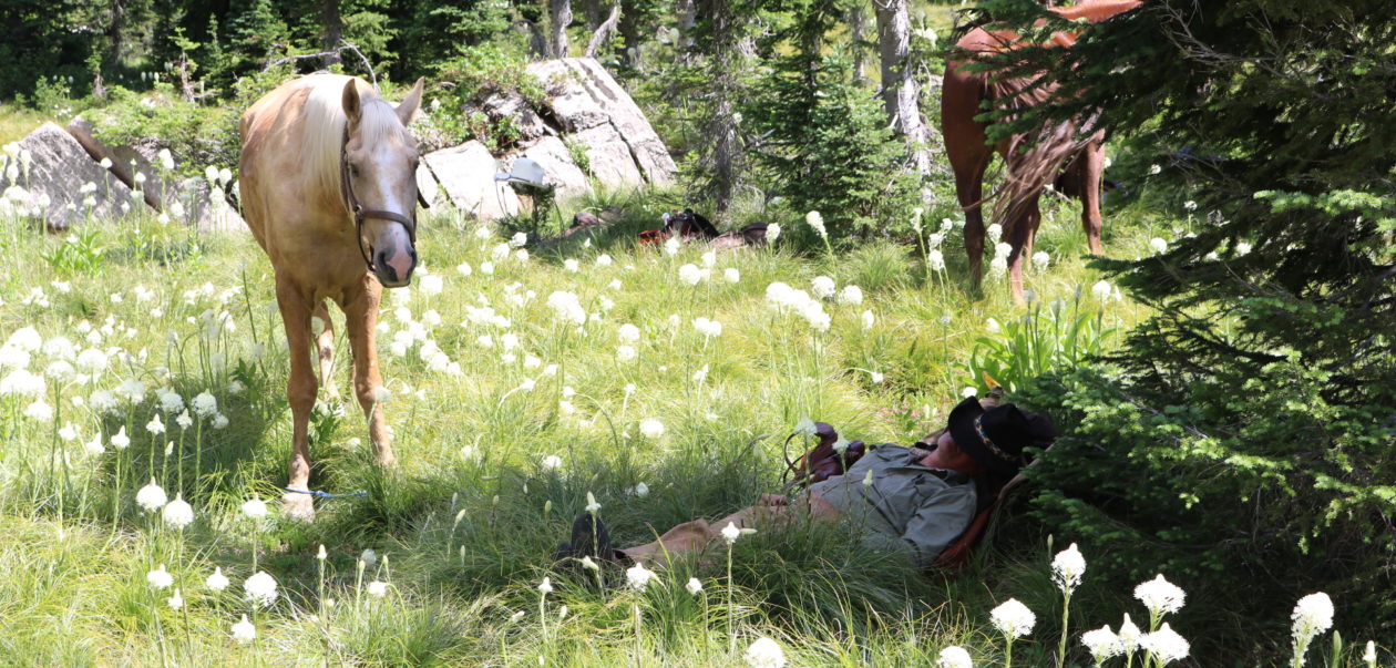


You must be logged in to post a comment.