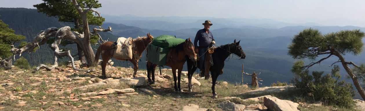
I visited Utah and New Mexico last month for college graduations of two of my kids. I also spent some time in Arizona with my parents. While I was in Arizona, Dad and I took a ride part-way down Raspberry Creek Trail. I have selected this trail as part of our Great Western Trail ride, planned for 2015. I had heard the trail was burned-out and eroded so badly that it was impassable. I wanted to see how bad it was. I have attached several photos of the ride in this post, but you can see the full album in the WTR Gallery.
Turns out the trail, at least the upper part of it, has been maintained by a rancher who has a range lease in the area. The trail was in great shape. The Wallow Fire, that burned through the area three years ago, didn’t do as much damage as I had been lead to believe on this trail.
There were several places that were obviously affected, but it looked like spot-fire burns and most places were simply thinned-out by the fire, rather than scalped. There were areas visible from the trail that received much worse damage than the trail itself received.

The trailhead is about 62 miles south of Eagar/Springerville, AZ and about 35 miles north of Morenci, on highway 191. Highway 191, in that area is closed during the winter, but opens as soon as the snow begins to recede. The elevation passes the 9,000 ft. mark around the Hannagan Meadow Lodge area up on top. Several great trails that lead down into the Blue Wilderness Area head there at Hannagan (Steeple Creek, Grant Creek, Foote Creek). A note of warning about Highway 191, is that it used to be designated Highway 666. The name was changed because folks felt 666 was inappropriate for a highway designation. If you think “Highway 666” is an inappropriate name for a highway, you haven’t driven this one. Rigs over 40′ are highly discouraged.

It is a two-lane highway that winds its way down the Mogollon Rim and drops several thousand feet in a matter of a few miles. Check your brakes before you leave Hannagan if you are coming from the top.
Back to the trail. The trailhead is at a designated camp area called “Strayhorse”. It is about 2.5 miles below the “Blue Lookout” scenic vista point, and about one mile below the famous “Arrow Tree”.

The trailhead has camping areas (although camping is unregulated in this area), enough parking area for several stock trailers (remember, trailers longer than 40′ are highly discouraged), toilet facilities, and a small corral. No water service. On the west side of the highway you will find the trailhead for Strayhorse Trail, which leads to other trails, such as Eagle Creek (up which our GWT ride will come), Salt House Creek, Chitty Canyon, Rim Trail, and several others. One can ride trails from Strayhorse all the way to Morenci, or on up to Alpine, and further. On the east side of the highway, is the Raspberry Creek Trailhead, which drops 9.5 miles to the Blue River, just south of the Blue Wilderness Area. I “guesstimate” the elevation at the trailhead to be around 8,000ft. By the time you reach the Blue River you will be at around 4,000ft. I haven’t checked those figures by map or GPS, but they are in the ballpark.

From the Corral you head toward the restrooms and continue past them, and you’ll find the trail. At that point it looks like a two-track road, which it is.

Follow that for about a quarter mile, and you’ll come to the USFS sign for the trailhead. Just past that, you’ll see a small cabin and corrals with some livestock. That is the rancher’s headquarters for his range lease. If you see him, you might thank him for maintaining the trail. He has a bathtub water trough near the cabin, fed by a capped spring. I’m sure he wouldn’t mind folks watering there, but be courteous and conscientious of his ranch and livestock. There are some natural springs where you can also water your horses on the trail.

As we passed the cabin, we noticed several horses, a mule, and a donkey hanging around the place. The donkey, a young jack, decided he was in love with Honey the mule, ridden by Dad, and fell in with us for the entire ride.
The trail was in excellent shape, with rocks placed to control runoff and erosion. The trail was well-planned and laid-out. As I mentioned, it drops close to 4,000ft in under 10 miles. There are switchbacks where needed and the the descents and climbs are reasonable. We crossed a number of runoff streams, that likely go dry most of the year, and passed several small springs along the trail. Not much grass to be had, but there is a little in certain areas you will pass. Not enough for daily feed for horses, so we plan to carry feed for our GWT trip as we pass through this area.

The trail is quite rocky, so unless your horses are kept on similar ground and their hooves are toughened up, shoes, or at least boots, are recommended. Barefoot horses will be tender by the time they reach the bottom.
For this ride, our purpose was only to check out the upper part of the trail, which I had been told was damaged by the recent fires. We rode about three miles down the trail, then back to the trailhead. Even that was a nice ride. Our mounts were tired by the time we finished the climb out.
On our ride back to the trailhead, we encountered a pretty good-sized Timber Rattler. He was about four feet long and every bit of three inches in diameter. He was sunning himself on the trail. I heard the warning rattle and felt my horse tense up, so once I located the snake, I got off and lifted him off the trail with a good, long, stick. Rattlers aren’t all that aggressive, and normally only strike when they are severely bothered. I consider them to be quite considerate critters. At least they give a warning and let you know where they are, and give you a chance to avoid trouble.

As for wildlife, you stand a good chance to see elk, mule deer, bear, desert bighorn sheep, mountain lions, coyotes, smaller varmints, and even Mexican Gray Wolves. We always carry a firearm when we ride the area, as much for protection from the lions and tigers…er wolves…and bears (oh my!), as for use in case a horse should go down. Our preference, not necessary. On a day ride, you’re not likely to have any problems, but if you decide to make it an over-nighter…well, you decide for yourself.
Weather was severe clear, as is common in Arizona. Protection from the sun is essential at this elevation. A wide-brim hat and neck scarf, and chapstick are recommended, as well as long-sleeved shirts. Carry at least a two-quart canteen. Always carry a jacket, even in the summer. If you should end up afoot overnight, you’ll be glad you have it. You’ll also need sun protection for your horses, if you have any with pink skin on their noses, ears, and eyes. Otherwise, they’ll definitely sunburn.

This part of Arizona is extremely remote. You are not likely to meet anyone on the trail, on foot or mounted. There is no store or fuel facility for over 30 miles from the trailhead. The closest hospital is in Morenci, about 35 miles or so south of the trailhead on Hwy 191. Cell coverage is spotty, but isn’t reliable until you get back up on top, near Alpine, or farther down near Morenci. Dad got a text message while we were at the trailhead, though. Just sayin’. Keep these things in mind while planning your trip.
Going from the top down to the Blue, you will find it a relaxing and enjoyable ride. The descents aren’t particularly difficult ones, and, like I said before, the trail is well designed. The switchbacks are well laid out. The portion of the trail we rode was well maintained and in excellent shape. This trail would be appropriate for riders and horses with some experience on the trail, but we encountered nothing that we considered particularly challenging. That is not to say that farther down the trail, there might not be some obstacle. Our purpose for the ride was to check out the upper portion of the trail, which I had been led to believe was burned out and eroded to the point of being impassable. We were surely pleased with what we found.
I have never ridden Raspberry Creek Trail top to bottom, so I can’t say what might be found further down than we rode. My experience on other trails in the area, most of which are no longer maintained by the USFS, is that they are often blocked by fallen trees. Most of the time one can cross over or maneuver past them. Once one gets to lower elevations, the pines thin out and give way to Juniper and Pinon. From that point the trails are normally in pretty good shape. I felt like our ride got us down below that point and that the trail on down to the bottom would likely be in good, or at least passable, condition.
The road from Alpine, AZ to Blue, down in the bottom of the Blue River drainage, is almost always in good condition, although only a narrow gravel road, it is sufficient for a pickup and a stock trailer up to about 35 feet. From Alpine to the Raspberry Creek Trailhead at the bottom, would be about 30 miles or so. There is another road to the bottom called Red Hills Trail, that intersects Highway 191 at Beaverhead, however I would not take that road with more than a 4-horse trailer and very good brakes. If arrangements could be made to have someone with a trailer meet you at the bottom of Raspberry Creek Trail, it would make an excellent day ride. Otherwise you will be riding about 9.5 miles to the Blue River, then about that back out by another trail, such as Steeple Mesa, K-P Mesa, or Grant Creek Trail. That would make an excellent two or three-day pack trip that would bring you out on top at Hannagan Meadow.
Most of the trails in and around The Blue Wilderness Area, as well as the nearby Gila Wilderness Area, are old ones, many having been around for more than 150 years. Most are still marked by blazes on the trees every 100 feet or so, which have survived the years remarkably well. For many years the trails were used and maintained by ranchers to move cattle through their range leases. Over the past 30 years or so, however, the USFS and BLM have placed such severe restrictions on the ranchers, that there is insufficient traffic on the trails to maintain them, and the USFS and BLM have neither the budgets nor inclination to do so. Even though there is little foot or livestock travel on the trails nowadays, most of them are still well marked, except in areas where fires have burned out the marked trees. However, if these trails are not used and maintained by people like ourselves, they will eventually disappear altogether.
If you would like to give Raspberry Creek Trail, or any of the trails in the White Mountains or Blue Wilderness Area a try, hit me with an email and I’ll get you in contact with people in the area who would be more than happy to provide you with current information on trail conditions, places to stay, temporary corrals, feed suppliers, etc.
Plan a ride to the Raspberry Creek Trail. It’s the Arizona wilderness at its best.

You must be logged in to post a comment.