To those of you who have been following this saga from the beginning, thank you. You will be pleased to know that Dad and I are actually in the “OK! We’re going to do this!” stage now. For those just joining us, my father and I have been trying to plan a horse pack trip from Mexcio to Canada. We have both been dreaming about something like this since I was in high school and we’re finally going to make it happen. We’ve had to scale our plans back a bit…a lot…because of a number of factors coming into play. The thought of making it all the way from Mexico to Canada is still rolling around in our heads, but we’ve decided it would be much wiser for us to break the trip up into “legs” and try not to bite off more than we can chew at a time.
Our hope for this year, 2015, is to take the first two legs of the trip, from the Mexican border to
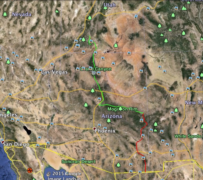
Panguitch, Utah. Shown in the graphic in red and green, as close as I can figure, using Google Earth and USFS maps, that will cover about 800-1,000 miles. I’m confident it will be closer to the 1,000 mile mark, since the Arizona Trail has been fully documented at 800 miles and our route through Arizona will be at least 100 miles longer than that, due to our desired stop in Eagar. We intend to document the trip by GPS, so there will be no question as to mileage and so anyone who wishes to follow our route later will have that information to help in their planning.
Truthfully, the second leg of the trip, from Eagar, Arizona to Panguitch, Utah, is the part of the trip Dad and I have been dreaming about. He and I have talked about crossing the Grand Canyon on our own stock for more years than I care to remember. From Eagar to Flagstaff, we’ll follow portions of the old Honeymoon Trail, which the early Mormon settlers of northeastern Arizona used to travel to be married in the LDS Temples in Utah. We’ll also travel the old General Crook Trail which he blazed from the White Mountains to Camp Verde in the late 1800s. We’ll then travel north on the Arizona Trail, crossing through the Grand Canyon, then on up through portions of southern Utah where my great-grandfathers used to ranch and run cattle. The legendary outlaw Butch Cassidy was known to have frequented the areas we’ll pass through. We’ll end up this leg, and likely our travels for the year, at Panguitch, Utah, where Dad was born and raised. This leg of the trip will be between 500 and 700 miles, as close as I can figure, and should take us about 6-7 weeks. Dad will turn 81 years old during that leg. There is a lot of history, both general and personal that we’ll be passing through on that part of our trip.
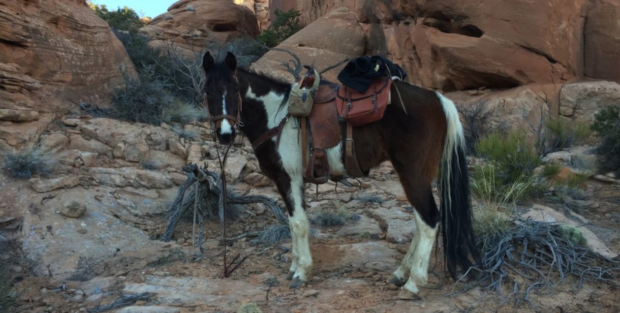
As of today, the plan is for us to depart sometime in April (a lot will depend on weather) and try the first leg of the trip. This will take us from the U.S./Mexico border just east of Douglas, Arizona, northward to Eagar, Arizona. That leg will be approximately 300 miles and should take us about three weeks, give or take a couple days. Eagar will be a sort of home-base for us, since that’s where my folks live. Once there, we’ll rest up for a week or two while we assess how we did and what we need to change. We will see how we feel about our horses, decide whether to add a couple to the string and whether any of the ones that made the first leg need to be changed-out. We’ll assess our gear – saddles, pack saddles, halters bridles, packs, cooking gear, etc. – and make adjustments where needed. Not among the least of things for a couple of old farts, we’ll assess our own health and determine whether our old bones can make the second leg of the trip.
 To add a little more detail, shown in the graphic in red, the first leg will have us departing from about Border Monument #77, just a couple miles east of Douglas, Arizona. We’ll track generally north from there, crossing State Highway 80 and on into the Chiricahua Mountains. As I will be taking my trusty trail dog with us, we’ll stay clear of the boundaries of the state park there, tracking around it on the east side. We’ll trend northwest from there, following portions of the Grand Enchantment Trail through the mountains until we come close to Safford, Arizona, where we’ll head east until we come to Eagle Creek. We’ll head north from there, passing east of the San Carlos Indian Reservation border, wind our way up to cross Highway 191, and head over into the Blue Wilderness Area. We’ll drop down off the Mogollon Rim and find Blue Road and follow it northeastward until we come to a friend’s place just south of the town of Blue. We’ll likely stay there a couple days and rest ourselves and the horses, before heading up Foote Creek Trail, or possibly Grant Creek Trail, back up on top of the Mogollon Rim near Hannagan Meadow. From there we’ll be tracking northwest, passing west of Alpine and Nutrioso and on up to Eagar, Arizona. That will be the end of the first leg, as I said before. As close as I can figure that should be very close to 300 miles.
That route for the first leg makes good sense for us, because it crosses roads at various places and passes through or near a couple of towns. That will make it a fairly simple matter for our logistical support. We already know we will have to pack our horse feed, or at the very least supplement it on this first leg. It’s not likely there will be much grass along that route at that time of the year. We will plan to have a driver meet us at planned locations to re-supply us with feed…for both horses and humans. From what I see on Google Earth, though, we should be fine on water for the stock and for ourselves all along the route that time of year, as there are numerous stock ponds and tanks and a few creeks. Snow run-off and rain should have them all pretty full.
After taking a couple weeks for rest and recuperation, as well as assessment and adjustment as necessary, there at Eagar, we hope to embark on the second leg – the trophy leg – of our trip. This route, shown in green in the graphic, will track northwest from Eagar, Arizona along the edge of the pine forests of the Tonto National Forest, to Show Low, Arizona. Just west of Show Low, we’ll meet the General Crook Trail, which is a designated trail for foot/equine travel. It will take us on down the mountains to Camp Verde, where we’ll join the Arizona Trail. The Arizona Trail will take us north, passing west of Flagstaff, Arizona (actually through Flagstaff for a short distance), then on

north to the park entrance to the Grand Canyon National Park. We’ll stop there to make all the necessary last-minute arrangements with the park service and the mule outfitters before heading down the designated trails to the bottom. While horse travel in the park is permitted on designated trails, coordination is necessary, so as not to encounter a string of mules coming the other way on a narrow portion of the trail. We’ll spend a night at the Ghost Ranch at the bottom of the canyon, to which I look forward with much anticipation. We could probably make it down and up in one day, but I can’t imagine making that passage without stopping for a night at the bottom of the Grand Canyon. That is something I have dreamed of. Sadly, my dog will have to travel this portion in the truck with the hired help.
From the Grand Canyon, we’ll move northward to cross U.S. Highway 89, where it makes a big jog as it crosses Paria Canyon. We’ll follow Paria northward to Willis Creek, which we will follow westward to the Grandview Trail. The trails up Paria and Willis Creek hold some spectacular scenery, winding through “slot-canyons” so narrow in some places that we’ll likely have to unpack our horses to pass through. The Grandview Trail wanders around the outskirts of Bryce Canyon National Park. It offers much of the same scenery, although from a less spectacular perspective, as the park does, but is on BLM land, which allows me to take my dog and is unregulated as far as horse travel. The Grandview Trail passes around the south end of Paunsaugunt Plateau (Bryce is on the southeast side of the plateau), then turns northward along the west side of the plateau. We’ll follow that trail up to Red Canyon, where we’ll come down off the plateau and make our way on into Panguitch, Utah.
We still have family living there in Panguitch, and Dad still has many old friends there. I expect we’ll be met there with open arms….and shaking heads. That will be the end of our trip for the year, completing the first two legs of our Mexico to Canada trip, covering about 800-1,000 miles.
It will also be the fulfillment of a long held dream for one son and his dad.

You must be logged in to post a comment.