
During July, this year (2018), a friend invited me to head into the Wind River mountains for a fishing horse pack trip. As things turned out, however, the fellow who was to guide us to his favorite fishing hotspots was unable to go. So, since my friend lives in Arizona and I needed a chance to visit my parents there, we decided instead to head for the Blue Range Primitive Area in eastern Arizona.
When I was 15 years old, way back in 1974, my father took my younger brother and I on a hunt trip into the Blue Range Primitive Area in eastern Arizona. We had three horses with us. Only Dad was successful in bagging a deer, but all three of us had a successful father and sons experience.
At the end of the hunt, Dad drove our truck and trailer to the top of Red Hill Road and parked it at the upper trailhead for Red Hill Trail. He then hitchhiked back down to us and we rode the horses up Red Hill trail to the top. It was a true old west adventure for Craig and me. We stopped for lunch near the peak of Red Mountain, under a huge juniper tree. We had forgotten to bring any silverware, so we all ate from a can of Van Camp’s Pork-n-Beans with a wooden spoon carved by Dad. That wooden spoon experience on Red Hill Trail started a  tradition in my family. It remains one of my fondest memories from my boyhood. All my kids know that story and all have eaten pork-n-beans with a hand-carved wooden spoon.
Since that first trip, the Blue Range Primitive Area has been my favorite part of the whole world. Partly, I guess, because of the memories, but also because of the rugged and interesting terrain. Falling from just under 9,000 feet elevation at Hannagan Meadow to about 5,000 feet on the lower Blue River, the trails of “The Blue” pass through a broad spectrum of terrain and plant life, from Douglas fir and aspen forests to scrub juniper, red cliffs, and desert brush. A wide variety of game and other wildlife make the Blue their home, including the recently re-introduced Mexican Wolf.
So, in light of our current situation, my friend, Sterling Beus, and I decided to take advantage of the opportunity for me to haul my horses down from Utah and take a pack trip that I have wanted to do for many years, while at the same time allowing me to visit my parents in Eagar, Arizona.
I hauled my two horses, Lizzy and J Golden, along with my daughter and son-in-law’s two Tennessee Walkers, Bandit and Trigger, from home in Salem, Utah, down to Eagar, Arizona, on Thursday, August 2, 2018. My 2005 Dodge Ram 3500 recently received a remanufactured transmission, so this was a good break-in trip for it. The drive was about 10-1/2 hours, but all went well. At my parents’ house, I let all four horses into their corral with my mustang, Jimbo, and Lizzy’s yearling colt, Chief. After some running around and getting rank and file settled, they all settled into a friendly relationship.

Sterling and his son, Tyler, showed up on Friday afternoon and shortly thereafter we departed for the two-hour drive to the trailhead. In my trailer were the four horses I brought down. We camped at the trailhead at Hannagan Meadow and spent a pleasant evening getting reacquainted and eating some tasty steaks cooked over a fire.

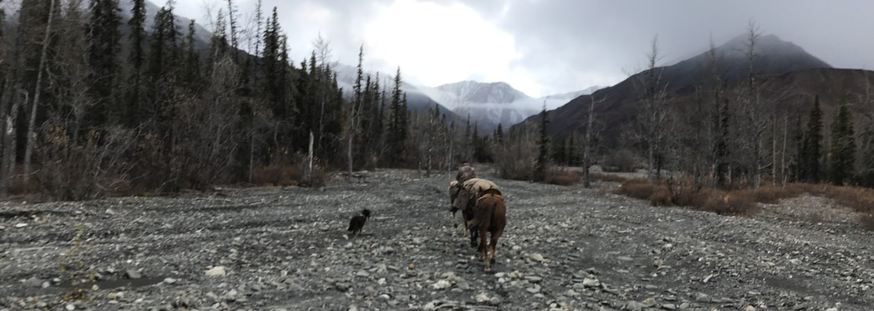
The following morning, we packed up and headed down the trail. As usual, when beginning a pack trip, it took a few minutes for the horses to settle down and get their minds on the business of gaiting on down the trail. This is one of the times in which I truly appreciate the value of our Tennessee Walkers and Missouri Fox Trotters on the trail. We moved on down the trail averaging about 6-7 miles per hour, while enjoying the smooth running walk (my Fox Trotter, Lizzy, was our pack horse) of the Tennessee Walking Horse.

We started our descent into The Blue on Foote Creek Trail (#76), following it to P-Bar Lake. Somewhere near P-Bar lake, we encountered a pair of hikers, who were out scouting for elk. They told us Foote Creek Trail was impassable below Paradise Park, which agreed with information I had from other knowledgeable sources. Because of that information, the route we chose was to descend to the Blue River by Grant Creek Trail (#75) from Paradise Park. Just southeast of P-Bar Lake, which is actually nothing more than a small stock pond, Grant Creek Trail separates from Foot Creek Trail. The “Y” is pretty plain, but the trails are not marked. With the aid of our USFS map and a rock cairn locating the trail, we took the trail leading in a southerly direction and were pleased to find further along that it was the right trail.
We found a couple official trail markers along our route, one marking a shortcut over to Moonshine Park, but we stayed with the trail we were on and descended into Paradise Park. Paradise Park is a small valley which spreads out over maybe 30 or so acres, with large pine trees, grass, and, at times, a few small ponds of water. It would make a very nice camp area for hikers, but the inconsistency of water makes it only a stopping area for horses, where they can graze while resting. This area was touched by the Wallow Fire, but not entirely destroyed. It is recovering well.
Below Paradise Park, the trail is marked, although poorly, by a series of rock cairns. The trail itself is difficult to see in many places, but by keeping a sharp eye out, we were able to locate just enough rock cairns to keep us on the trail. About a half mile or so below Paradise Park is a turnoff to White Oak Spring. We found the fence and gate in disrepair and the trail marker stuck in the wire on a post, not in its original position, nor accurately pointing the way to the spring. Having been to the spring many years before, I knew the way. The spring lies just over a hill and down into a small gorge. It has been improved by ranchers over the years and currently consists of a capped spring with a plastic pipe running into two water troughs. Canteens can be filled without concern from the pipe and there is plenty of clean, cool water for the horses. There is also a small wire corral and a good patch of grass. This was our lunch stop. We unloaded Lizzy and loosened cinches for a nice rest.
From White Oak Spring to the bottom of Grant Creek, the trail was very difficult to stay on. We lost the trail a number of times, reacquiring it only by scouting back and forth until we located some sign of a trail. Sometimes the only indication of a trail was the smooth edge of a tree branch that had been cut off by a saw to clear the trail many years before, or the remnants of a log set in the trail to divert runoff water. In most places the actual trail was no longer visible at all. In this section there were no rock cairns. This area was only minimally affected by the Wallow Fire, but there is so little foot or horse traffic that the trails are simply vanishing. It is important to try to stay as close to the trail as possible, as the terrain becomes quite steep and there are bluffs in places and one can get himself into a jam pretty easily. The trail follows the only safely passable route to descend through the lower part of this area to Grant Creek. A good, reliable and experienced trail horse is a great comfort to the rider here.
Once into the creek bottom, the trail was easier to follow, although it was not an easy trail. Much of the trail has washed out and there has been no trail maintenance in many years. However, due to the close and very vertical terrain, it is pretty easy to determine where the trail has to be. With a little brush-busting and a lot of log crossing, we made our way down the trail.

About 3/4 mile or so from the confluence of Grant Creek with the Blue River, we noticed clouds building north of us and heard the unmistakeable roll of thunder in the mountains. We decided to make camp a little early, so that if we got caught in a monsoon shower, we would be not be unloading packs in the rain. As it turned out, the storm passed north of us and we got no rain at all. Still, it was a nice camp area.
Surprisingly, while the weather was mild, it was very, very humid. July and August are the monsoon season in Arizona. I am an Arizona boy, but I have never experienced such humidity in Arizona before. It reminded me of summers in Virginia. Still, and even more surprisingly, flies and mosquitoes were not a problem. It was nice to have a good flow of water in Grant Creek, in which we could bathe and cool off a little. There was also plenty of grass for the horses. It was a nice camp area.

We enjoyed a small camp fire and good conversation that evening. Our meals were dehydrated package meals. They were surprisingly tasty. We got no rain that night, so we stayed dry on the outside. Inside our clothing, however, we sweated. It was so warm that we ended up sleeping on top of our bags most of the night. Luckily, as I said before, mosquitoes were not a problem.
 The next morning, we packed up, cleaned up our camp, and headed on down the trail. I decided to give J Golden a try as a pack horse, since I had broken him to the pack way back in June. I rode Lizzy and put Tyler on Bandit. Sterling remained on Trigger. At first, J gave me a little trouble, as he still didn’t like the hard panniers. He kept trying to get up next to Lizzy, which caused the pack to bump her rear, making her more concerned with J than with the trail ahead. After giving J a couple good “whops” on the nose with a loop of lead rope, he began to stay back and Lizzy resumed watching where she put her feet on the trail. It didn’t take long, before all I had to do was raise my hand and J would fall back in line behind Lizzy. He became a pretty good pack horse.
Just a short way down the trail, Tyler came upon the largest Western Diamondback Rattlesnake I have ever seen! It was lying just off the trail, sunning himself. His rattlers were going full blast, but he would not move. I have never been too concerned with rattlesnakes bothering my horses, but Sterling’s Labrador would have been in real danger from this fellow. After we took a handful of photos, Tyler got off the horse and held Missy’s collar while we all walked around this big old snake. Without exaggeration, he had to have been at least a full 4″ in girth and 5′ long, possibly 6′ (we didn’t get close enough to measure). His head was as big as my fist. He was a big ol’ boy!

After getting past Mr. Rattler, we made our way on down to the Blue River and onto Blue Road. Our plan was to follow Blue Road to the Foot Creek Trailhead, where we planned to check out the lower part of Foot Creek Trail (#76) up to Cleveland Spring Trail, then take that over to the Red Hill Trail. However, it seems the trail marker for Foote Creek, that used to be there, is no longer there and we missed it. We had passed it by more than a mile before we realized it, so we just continued on Blue Road to the junction with Red Hill Road.
At Red Hill Road, we took a break and had a late lunch. There is a designated camp ground there, complete with restroom, camp shelters, picnic tables, and even ancient petroglyphs. We stayed outside the campground, though, where the horses could graze on the lush grass on the shores of the Blue River.
After relaxing a while, I started thinking about the trail back to the top and realized we probably would not see any water anywhere on the trail. We were also starting to see large storm clouds gathering around the mountain tops. We decided we were not likely to find a better campsite than right were we were, so we crossed to the south side of the river and set up camp under some trees. The horses were more than happy to continue grazing on the grass that reached nearly up to their knees.
I again learned that I can’t leave Lizzy free at camp, unless at least two other horses are tied. She tends to move a lot while grazing and the other horses follow her around. I had her and Trigger both hobbled, yet, when I looked up to check on them a while later, Lizzy had led all the horses across the Blue River and they were grazing on the other side. I walked over, crossed the river, and walked in among them. I caught up Lizzy and Trigger and removed their hobbles, then  decided to try something I have not done in a very long time. I decided to see if Lizzy would allow me to ride her bareback. She had never been ridden bareback, to my knowledge, and I hadn’t tried it in nearly 20 years. I got her up near a small bank and slipped up onto her back, only then realizing I hadn’t tied her lead rope up to make reins. I reached up, leaning on her neck, and tied the tail end of the lead rope onto the halter ring. Then I gave her a leg cue and away we went. Didn’t even need the reins. She calmly took me back across the river and over to camp, with the rest of the herd following. I was quite pleased. We decided to highline the horses, not wanting to chance them wandering off in the night.

This was a very nice camp. We decided to forego a campfire, because we were simply too tired, and just cooked our meal on the single-burner Coleman propane stove I have used for years on my pack trips. After eating our re-hydrated meal, we laid out our beds and relaxed a while before bedding down. While we still suffered from the humidity, a storm front passed through, dropping the temperatures a few degrees. We only received a few drops of rain, however, but the thunder rolled around the mountain tops most of the evening and the lightning gave us a very nice light show as evening drew on. Again, mosquitos were not a problem. It was very pleasant.
The next morning, we packed up and started up Red Hill Road to Tut Creek Trail. The trailhead is about a quarter-mile west of Red Hill road about a half-mile above Blue Road. There is a decent dirt road to the trailhead, where there is a sufficient parking area for several large rigs. There are several metal corrals, as well. No restrooms, though.

We packed J again, he having proved himself a pretty good pack horse the day before. He had learned and performed his job so well, in fact, that I tied his lead rope up on his pack and let him go. Interestingly, whereas J doesn’t

normally care much for leading the group and generally does a lot of looking around to make sure everyone is following, with his pack in place, he just took off down the trail. I think he was happy following Missy, the Labrador. When we came up to the Tut Creek Trailhead parking area, he took off on his own and decided to go check out the corrals. I enjoyed his new-found confidence as a pack horse.
About a quarter-mile down Tut Creek Trail from the trailhead, we came into the creek bottom, where we found the trail marker indicating Red Hill Trail heading north, while Tut Creek Trail continued west. We headed up Red Hill Trail, following the creek bottom and watching for rock cairns marking the trail, as the trail was seldom clearly visible. There was no water in the creek bottom.

About a mile-and-a-quarter up the creek bed, we were lucky enough to notice three rock cairns in a row about 25 or so feet apart, which, when lined up, pointed off to the west side of the trail. This is the point at which the trail leaves the creek bottom and starts up the mountain. The trail, at this point, looks like a game trail, rather than a designated foot trail. There has been little traffic and no maintenance on it in a very long time. This trail ascends the mountainside along a ridge at the rate of about 1000′ in about a 1/2 mile. I’m her to tell you it was a tough climb for the horses.
About 3/4 of the way up this hill, there is a quick jog in the trail, where it turns around the corner of a fenceline. There is a rock cairn there that marks the switchback, but it is easy to miss and apparently it has been missed before, because the trail goes on past the switchback and ends up, who knows where? We were lucky enough to spot the rock cairn. We checked the map and it also showed a quick jog at that point, which confirmed to us that the switchback was correct. From that point, the trail heads up the sidehill toward a saddle. This trail was extremely rocky and steep. This is not a trail for a beginner. It was hard work for our horses, which are seasoned trail horses. We stopped several times to let them take a breather.
As we crossed the summit in the saddle, we completely lost the trail. We dismounted and spent nearly half an hour searching for the trail. We kept coming back to an old, barely visible blaze in an oak tree, right where the trail crossed the summit. Finally, we decided to continue following what we believed was the trail, which now descended into a valley on the opposite side of the mountain. We crossed a number of downed logs in an area that was somewhat affected by the fire and, picking our way along carefully, near the bottom discovered an old blaze on a standing Ponderosa Pine. From there, we followed the only logical route for the trail, which lead up a ravine heading northwest, finding the occasional old blaze to assure us we were still on the trail.
Now, I should clearly state here that these blazes were long healed over and only visible if you knew what you were looking for. We looked for a scar on a tree that had a matching scar on the other side. They did not look like blazes, only healed scars on the trees. If there was a matching scar on the other side of the tree, it was likely a blaze. We were lucky to find enough of them on trees that had not been burned down, that by also consulting the map we were able to find our way up the trail.
Throughout the ascent on Red Hill Trail, we were treated to spectacular views. With the recent rains in the area, the air was crystal clear and visibility was well over 50 miles.


About halfway up the trail, it crosses Red Mountain. Where it crosses near the peak, there is a broad open area with several huge Juniper trees on it. That is where, when I was 15 years old, my younger brother, Dad, and I stopped for lunch and ate a can of Van Camp’s Pork-n-Beans with a hand-carved wooden spoon, under the shade of one of those ancient Juniper trees. Sterling, Tyler, and I stopped under that very tree and had our lunch. I’m sorry I didn’t have a can of beans to celebrate my “homecoming.” It was for me a pleasant thing to return to that spot and recall fond memories from nearly 45 years before. That was one of the highlights of the trip for me.
(I got some video of the big old juniper tree on my GoPro. I’ll try to extract a photo from it and insert it later)
After lunch and a much needed rest for the horses, we continued on up the mountain. Again, the trail was difficult to stay on and we lost it a time or two, but within about a mile we again began to see the occasional rock cairn. While the ascent was still quite steep and was tough on the horses, it was much less precarious and difficult than the section of trail we had just completed. We were now back up into the Ponderosa Pines and tall grasses. The air was also drier and cooler. We had ascended nearly four thousand feet above the Blue River in a very short distance, as the crow flies.
By this time, we could tell the horses were thirsty. At one point they wanted to leave the trail and head off down a deep gorge. We can only assume they smelled water in that direction. Once over the last summit, we descended into the valley in which Red Hill Road is located. As we descended, we came through an area where there were many blowdowns. We crossed log after log in that last half mile before the trailhead.

We reached the upper Red Hill Trailhead about mid-afternoon. The horses hadn’t seen a drop of water since we left the Blue River that morning and they had had a very tough day. In all, our trip was about 30 miles in three days.
At the trailhead, we unsaddled Trigger and J and rode the quarter-mile or so to Red Hill road. We found a small water hole a little ways east of the trailhead road, where we watered the horses. After they all had their fill, we headed back to the trailhead, where we had previously staged a pickup. We left Tyler with the horses, while Sterling and I went to retrieve my truck and trailer from the trailhead at Hannagan Meadow.

After loading up, we headed home, stopping in Alpine to celebrate our successful pack trip with a nice dinner at the only decent cafe in town. Sorry, but I can’t recall the name of the place. Food was good, though.
I love the Blue Range Primitive Area. It remains my favorite part of the whole wide world. I can never get enough of riding my horse through that country. There is no end to the interest it holds for me. I have, at various times in the past, seen elk, both whitetail and mule deer, desert bighorn sheep, pronghorn antelope, black bear, and even a wolf in that area. I took the largest mule deer I have ever harvested down near the lower trailhead of Red Hill Trail, many years ago. I absolutely love that area and have many good memories attached to it. It’s too bad I live so far away. It was a real pleasure and a choice opportunity for me to head down into that country with good friends and good horses for an excellent three-day pack trip.
Here’s the Ramblr link for map, stats, and route:
https://www.ramblr.com/web/mymap/trip/303226/1158047/

You must be logged in to post a comment.