
I’m finally getting around to writing up my solo horse pack trip from October, 2020, down around the southwest end of the Paunsaugunt Plateau in central Utah. It’s been awhile, but I always keep a hand-written journal, so I will refer to it to refresh my memory. I’m sorry to say, however, that since it was a solo pack trip, there aren’t as many photos as I would have liked and none of myself. Still, it was a refreshing and enjoyable trip, which was the whole purpose of the thing in the first place.
I had high ambitions for this trip, at least in the planning. My intention was to drive down to the Losee Canyon Trailhead, near Bryce Canyon National Park, Utah on Monday, October 19, set up a camp, and ride the Thunder Mountain Trail that afternoon. That trail is a fairly short out-and-back, so I would return to camp that evening. The following day, I would pack up the horses and head out for a 2-day pack trip, starting on the Grandview Trail #66, southward to Badger Canyon, then eastward up to Tropic Reservoir, returning northward across the top of Paunsaugunt Plateau to the top of Casto Canyon, thence descending Casto Canyon and returning to my point of beginning on Wednesday evening. I calculated it would make about a 50-mile trip. Then, on Thursday, I was to drive across the plateau to Canonville, where I would stop and ride Willis Creek, before heading on down to set up a camp near the trailhead for Buckskin Gulch, just south of US89, between Page, AZ and Kanab, UT. I would ride the Gulch, about a 20-mile ride, on Friday. Then, on Saturday, I would spend a little time doing some scouting between the Gulch and the North Rim of the Grand Canyon along the Arizona Trail, in preparation for my crossing of the Big Ditch next spring. I was seriously looking forward to this trip!
Things started to unravel several weeks before the trip even took place, when my 2005 Dodge 3500, sporting over 350,000 miles, began to have problems. I had taken a weekend trail ride trip with Jon Tanner and friends up to Red Castle in northeastern Utah a few weekends before. The last several miles before reaching our camp area was on a very rough washboard dirt road that nearly rattled my pickup apart! After that, several things failed. The “Check Engine” light came on, my air conditioner stopped working, and my alternator became intermittent. Then, the weekend before this pack trip, coming home from a ride out in Skull Valley, Utah, a fitting on a power steering line came loose and leaked out all my power steering fluid. With some help from a good Samaritan in Eureka, Utah, (where there is no auto parts store and no cell signal at all) I was able to repair it well enough to limp on home. Once I repaired the power steering system, there was obviously an electrical problem somewhere in the system still to deal with. I connected my code reader to the OBDII port on the pickup and was surprised to find it would not connect.
I replaced the alternator and just disregarded the A/C, since winter was coming on anyway, and thought I had fixed things. I headed over to the Dodge dealership to see if they might be able to re-program the pickup and solve the “Check Engine” issues. Their advice was, that since it was running, not to attempt to re-program it, because, in order to do so they would have to “wipe” the truck computer, then re-install the programming. My year of truck was known to have a glitch in which it sometimes would not accept the re-programming, which would necessitate the purchase of a new computer…which are in short supply and very expensive. I decided to just let it go.
So, I went home and started tracing out my electrical harness and trying to locate anything that might be an electrical short. I located a pair of shredded wires that connected to the A/C compressor. Eureka! I thought. I repaired the two wires, hoping that would solve all my troubles. It did not. Still, the pickup was running well, just a little under-powered. So I decided to continue with my plans.
On Monday morning, October 19, I went to the car wash and used the engine de-greaser to clean off as much of the power steering fluid as possible, from under the engine compartment of the truck, so I could make sure the power steering leak issue was fixed. It seemed to be ok. However, I then discovered that one of the duals on the rear of the truck had picked up a drywall screw and had a slow leak. So, I spent the rest of the morning at Big-O tires in Spanish Fork, getting that repaired.
Finally, about 3:30 in the afternoon, I was packed up and headed south. By the time I was halfway to Panguitch, Utah, I knew something was still very wrong. On some of the uphill pulls my truck just felt weak and I was having 18-wheelers passing me! My fuel mileage was also way down. Not only that, but during the drive I suddenly remembered that I had forgotten to grab my riding boots and toss them into the trailer! And here I was with only my low-top tennis shoes! Could anything else go wrong? I finally made it to my selected camp area, near the Losee Canyon Trailhead, just in time to set up camp before dark.
I determined that I would go to Panguitch the next morning and see if I could buy a pair of boots and look for a particular sensor for the pickup that seemed to be at the root of the engine problems.
Due to the delays and other issues, it was pretty clear I was going to have to make adjustments to my plans for the trip. I had conversed briefly about things with Jon Tanner, who I think knows every trail in Utah, about my trip. He suggested that my 50-mile pack trip might take longer than the two days I had planned and that I might consider alternate routes or adding a day to it. He also mentioned that the Grandview #66 trail was the same trail that started the Thunder Mountain Trail, so I decided that I would just take the Thunder Mountain trail, which is an out-and-back that takes off from the GV#66, as I started out on my pack trip. That would save a day. I also decided to allow a third day for the pack trip, which would mean I would have to eliminate the scouting trip on the Arizona Trail.
So, with all that settled in my mind, I went to bed.
Tuesday morning, I arose, made myself a nice breakfast, then headed in to Panguitch. I have fond childhood memories of Panguitch, since it is a prominent part of my heritage. Panguitch was settled in the late 1800s and my ancestors were among the first to settle there. In fact, the first large home built outside the old fort, according to family history, was built by Samuel Henrie for his large family. That home still stands…although there is disagreement as to which home it really was. My father was born and raised in Panguitch and my family often visited there on vacations when I was young. I have very fond memories of my grandmother, Nina Hatch, and great-grandmother, Mary Houston, who were permanent fixtures and part of the history of Panguitch. I have cousins who still live in Panguitch.
Anyway, back to the point at hand – I went directly to the local western clothing store to buy boots…only to discover they do not sell boots! They advised me to check the local Ace Hardware. I was very happy to find the Ace Hardware, being the only store in town that sells boots, had a pair of Georgia Boot Wellingtons in my size! Not what I was hoping for, but would do the trick, so, out the door I went with them. I then headed for the local NAPA Auto Parts store. They did not have the part I needed in stock, but could have it the following day. Instead, I bought a can of brake cleaner and decided just to try to clean the sensor and see if that would fix it.
So, armed with new boots and a can of brake cleaner, I headed back to camp. After cleaning the sensor and re-installing it, and starting the truck just to make sure, I was satisfied that at least things were no worse. So, I decided to continue with my trip.
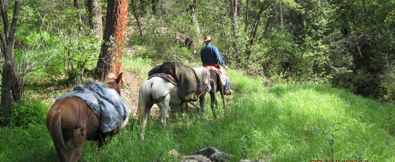
I got all packed up and on the trail by about 1:30pm. On this first day, I decided to ride Copper and pack Chief. I had Chief loaded with light packs, being probably 150 pounds total. I don’t need much when I pack solo. I decided to use the soft panniers on this trip, since I wasn’t taking enough gear to fill my hard panniers. Copper, on the other hand, had quite a load: Me, my 40-pound saddle, saddle bags, pommel bags, canteen, etc., totaling probably 270 pounds or more. I would be switching off between the two horses, so I wasn’t too worried about overloading either one.

We had about a two-mile ride back to State Route 12, crossed it, and made our way to the trailhead. Now, outside the park boundaries is BLM land, so dispersed primitive camping is allowed pretty much anywhere outside of the highway easements. The Grandview/Thunder Mountain trailhead has a very nice paved parking area that can accommodate several horse trailer rigs, but there is no overnight camping there. It is located on Route 12, about two miles east of US89, just as the road starts up into the canyon.
We passed through the parking area, stopped to take a look at the signs and information board, then headed out. Just a note about the trail sign: The Thunder Mountain Trail # .098, is a trailhead for pedestrian and bicycles. I don’t believe equines are allowed on that trail. Most of the hikers and bikers seem to start on that trailhead and either do and out-and-back or complete the loop, returning by way of the Grand View #66, because that route is generally a downhill trail. That trailhead is located a little ways farther up the road. For equestrians, taking the Grand View Trail #66 will get you to the Thunder Mountain trail within a mile or so, where you turn off and do an out-and-back.

We encountered several small groups of bikers on the trail, which is something to keep in mind, as some bikers have absolutely no understanding of what to do with a horse encounter and many of them come literally blasting down the trails on their nearly silent bicycles! Thankfully, the several bikers we encountered were very courteous and careful and my horses are very accustomed to foot and bicycle traffic and we had no problems. We also encountered several hikers and backpackers. This was Copper’s first time to encounter a backpacker with a large pack and he stepped very lightly around the first one. After that all was well.
The landscape and topography was stunning in those first few miles – red cliffs and green cedars/junipers. It got even better as we climbed and the views became longer. Both horses were excited to be on the trail and moved out at a good pace.


I decided to forego the Thunder Mountain Trail and just continued on the GV#66, due to our late start. I’m glad I made that choice, because things worked out pretty tight, time-wise.
After several miles, both horses started slowing down a little and settling into a solid walk. I had to stop a couple times to re-settle my top pack, which had my sleeping bag and some clothing items in it. It kept sliding off to one side, even though I had everything cinched down under a diamond hitch, so I had to do a better job of securing it.
I found there is water sufficient for the horses at various places. The first water we encountered, however, was in a creek about 7 miles in. There is a nearby ranch there as well, and a ranch road that heads westward to US89. After that, we came upon water about every two miles or so, in creek beds and water troughs. Grass is sparse, however and not sufficient for grazing until we got up near Tropic Reservoir.
At about the 8-mile mark, we came into a valley that had a marshy bottom. By this time, Copper was accustomed to following a trail, so I let him walk and spent a lot of time looking around at the beautiful country and dreaming my dreams. Suddenly I realized we weren’t on the designated trail! This area gets little foot traffic, since most hikers, bikers, and equestrians turn off onto the Thunder Mountain Trail, which we had passed several miles back. This bottom was criss-crossed with cow and game trails that evidenced more traffic than the designated trail!
Still unsure, we continued on, hoping to come upon some marker that would indicate were were back on the real trail, but things quickly became difficult. The growth became thicker, blowdowns were becoming a problem, and we were wandering around just trying to make our way through the valley, hoping to find the trail on the hillside on the opposite side.
As we made our way through the thicket, I turned Copper toward an open area that appeared to have a little stream of water passing through it. I figured it would be a good chance to give the horses a drink, since water is quite sparse on this trail. I stepped Copper over a fallen log and into the open area. As he stepped over the log, he immediately sunk nearly up to his belly! It was a bog! I let go of Chief’s lead, hoping he would stop and not enter the mud, while Copper struggled to get to solid ground. It was useless. Copper sunk up to his belly and quickly became mired. While he rested in the mud, I dismounted and began removing my gear. Solid ground was only about 10 feet away, so I carried all the gear there and dropped it, returning to Copper to remove the saddle. By this time, both Copper and I were pretty well covered in mud. I was beginning to appreciate the new boots I had bought, finding that they were waterproof, so at least my socks were still dry.
After getting Copper unsaddled and letting him rest a few minutes, I was able to help him get unstuck and he struggled to the solid ground. In the meantime, I had brought Chief around the bog and tied him, where he waited patiently. I wiped off as much mud as I could from Copper and re-saddled him and loaded my gear up. I decided that I would tie both horses and scout around on foot, to see if I could re-locate the designated trail, before mounting up again.
I led both horses into an area that was a little clearer, out of the thicket, and tied both to perfectly good aspen saplings with a little grass around them, then I headed off into the woods with my handheld GPS to find the trail. I hadn’t gone more than about 100 feet, when Chief started acting up. I watched him begin to circle around the tree, then stamp his feet, then he started kicking and jumping around. Since that is not like Chief, who is as calm as a summer evening, a thought quickly flashed into my mind: Wasps!
I ran to Chief and quickly pulled loose the safety knot to release him. He continued to pound around me, trying desperately to escape the stinging yellow-jackets while not trampling me! I headed off through the trees, leading him as quickly as I could, until I thought we were far enough away. I tied him to a tree and returned to get Copper, just as the yellow-jackets began their attack on him. I pulled his knot loose and quickly led him to where Chief was waiting. The yellow-jackets followed us!
I then grabbed both lead ropes and ran through the trees, with both horses following closely. We went nearly 50 yards before I was sure the wasps had stopped following. I then stopped and began swatting several wasps that were still hanging on and stinging the horses, until I got them all and the horses began to calm down. In the process, I was stung several times as well. Once we were all getting our wits back about us, I mounted and headed back along the trail that got us into the mess. I was quite proud that my horses handled the wasp attack as well as they did. It could have been a lot worse!
It wasn’t long before we came upon the designated trail, as confirmed by my GPS unit, and discovered that the designated trail had taken a turn, while a cattle trail had continued straight on into the valley, which is why Copper had missed the turn. Once back on the trail, I soon found a marker that confirmed we were, indeed, on the right trail.
The above setback, delayed us more than a half-hour, so I was beginning to be concerned that we wouldn’t make our planned camp area before dark. The area we were crossing had few areas that would make decent camps with horses, there being no water or grass and few level areas.
After a climb of another mile or so, we came upon a Forest Service “guzzler” that had water in it. We could have stopped at this place for the night, but we still had a bit of daylight left and I wanted to make it to Proctor Canyon, which was about another mile. I decided to keep going.
Past this point, the trail became pretty steep and quite sketchy in a couple areas. Nothing that was a problem for my horses, but for a horse not accustomed to rough mountain trails or for a rider not accustomed to riding on such trails, some of these passages would be quite intimidating, as we descended into some pretty steep canyon trails.
We finally descended into Proctor Canyon just as darkness settled upon us. I found a level area in a sage flat in the bottom of the canyon, near where an ATV trail crossed the GV#66. We made a dry camp there. There is a creek in the very bottom of the canyon, but it was in the bottom of a steep gulley about 30 feet deep and only about twice that wide. We camped above the creek on the flat. We had made 12.8 miles that afternoon.
I settled both horses, letting Copper graze on the sparse grass, while I unpacked Chief, then vice-versa, while I unpacked Copper. I tied Copper and left Chief grazing for awhile, before I tied them both and fed them from a sack of alfalfa pellets I had brought along for that purpose. Turned out Chief didn’t like the pelletized feed, so I put his hobbles on and let him loose for the night, while keeping Copper tied.
After laying out my sleeping bag, I prepared a quick dinner from a pre-packaged dehydrated meal, caught up my journal for the day, and went to bed. One thought I had, before I laid down my head: Why in the world did I decide to bring the soft panniers instead of the hard panniers! It would have been nice to have something to sit on at camp, while I took off and put on my boots! Also, hanging the hard panniers on the pack saddle and strapping it into place is so much easier than tying up a diamond hitch! Still, I have always been a traditionalist and love the old ways of doing things.
The following day, Wednesday, I arose to a very cold morning. I hadn’t slept very well. I had made the mistake of tying Copper too close to my bed site and he made a lot of noise all night long, because Chief was loose and he was not. I eventually got up and tied Chief as well, hoping Copper would settle down. I felt pretty good, though, so I must have slept more than I thought.
I made myself a breakfast of instant oatmeal and half a bagel, noting that while the water in my canteens did not freeze, the water in the bottom of my cup did! So, the temperature must have been hovering right around freezing. After the horses fed awhile, I loaded them up and we got started. I suppose it was around 9:00am when we headed out.
I had decided to try to get some video footage with my GoPro Silver camera, so I mounted it on the chest mount harness and donned my coat over it. In the process, I had removed the sheepskin vest I was wearing, so as to wear it over the harness. Somehow, I had laid the vest aside and forgot all about it and left it there at the camp. The worst of it was that all my video footage came out very poorly. Between the motion of my body and the motion of the horse, one could almost get motion sickness watching it. I plan to try to save some of it with software stabilization, but I’m not very hopeful.
Anyway, off we went, having to cross that deep gulley in the bottom of Proctor Canyon right off. I was riding Chief this morning, and he was feeling reluctant and a bit ornery, as youngsters sometimes do. I rode him around a little, leading Copper, to get Chief settled a little bit before starting down that steep and difficult descent into the gulley. After a few minutes I felt I could trust him and we descended the trail.

At the bottom of the gulley, I let both horses drink in the creek. While doing so, Chief acted up a little and I lost Copper’s lead rope. While I got Chief under control, Copper decided to head for home! My salvation was that he headed downstream in the bottom of the gulley, rather than back up the trail. I dismounted and tied Chief and headed after Copper on foot, since I knew that if I followed him on Chief, he would see that Chief was following and would not stop. As it was, I followed Copper about 100 yards, before he stopped at a particularly narrow place in the bottom and I was able to catch him.
With that little reminder about Copper, I should have been a little more careful with him, but, as you will see, my complacence came back to bite me later on.
The trail up out of Proctor Canyon follows a steep sidehill, but is a pretty decent trail, mostly used by cattle, ranchers, and hunters, and a few hikers. We made good time heading up the trail. The canyon forks and the GV#66 follows up the southern branch, while the ATV trail goes up the main canyon. We continued on the GV. At the top of the canyon there is a nice flat open area with a small pond and water tank.

The horses were not thirsty, so after a short breather, we continued on, departing GV#66 and heading eastward toward Badger Canyon on ATV trails. After a pretty tough climb, we joined the designated ATV trail (FRV233) and continued on, following Skunk Creek down toward the East Fork of the Sevier River.
About 12:30pm, we stopped in a nice open meadow and took a lunch break. I unloaded both horses put on their hobbles and let them graze. After the climb out of Proctor Canyon, they needed the rest. They stayed close by and exhibited no tendency to wander. They didn’t seem to like the grass too much, but they nibbled at it while I ate my lunch. A couple ATV’s passed on the road, but that was all the traffic we saw. We were pleasantly alone.

After about an hour, I loaded the horses back up and we continued on toward Tropic Reservoir. It was a nice, pleasant ride, among pine trees, aspen, and rolling hills. We arrived at the East Fork of the Sevier River around 2:30pm and followed it northward toward the reservoir. Just within sight of the reservoir, I decided to stop at a place where the banks of the Sevier River were low, to let the horses drink.

As we approached the river, all seemed well, but I soon discovered I had made a big mistake! As Chief stepped into the water, he sunk to his knees in mud. He simply relaxed and continued to drink, so I stayed aboard. Copper, on the other hand, continued into the water and was soon up to his belly in the mud and my panniers were in the water. He also continued to drink his fill. After satisfying himself, Copper began to lunge and buck his way through the mud and back out on to the bank. I tried to back Chief out of the mud, as his hindquarters were still on firm ground, however, he instinctively lunged forward and immediately sunk all four limbs deep into the mud. By this time I was trying to get off on the dry side, but my right foot went in up to my knee, filling my boot with water. I was able to get off and immediately began unloading gear from Chief. This time I got my pommel bags off and removed his bridle, but left the saddle in place, since much of it was under water. By this timeChief had gotten himself turned so that he was facing the bank. I was going to pull to help him, but when I saw his front right leg sink straight into the mud all the way up to his shoulder, I decided that in order to minimize the chance of him injuring himself, I should let him work his way out of it; a horse can easily break a leg in mud like that, especially if pulled off-balance.
After letting Chief rest a few minutes, I went to him and gave him a little encouragement to get him to start trying again. With quite an effort, he was able to struggle free and get back on solid ground. I wiped off as much mud as I could and checked him all over. He seemed ok, so I loaded back up and on we went. He walked with a slight limp for a few hundred yards, but was better after that. I assume he had a slight sprain in his knee or pastern on that front right, but I never saw any swelling and it caused him no further problem.

We stopped at a more solid place on the shores of Tropic Reservoir, where I let them drink again. I tried to wash as much mud as possible off myself and off my gear, and off Chief. From Tropic Reservoir, we followed the Fremont ATV Trail (FR091) northward on the west side of the valley. A couple miles past the reservoir, we came upon a small stream with grass along the banks, so I gave them another break. I didn’t unload them this time, just let them rest and graze.

By this time, Chief was getting pretty tired and slowing way down. He’s still a youngster, at 3 years old, and hasn’t quite come into his own yet. About another three miles along we decided to make camp out in a large plain in Paunsaugunt Plateau, with a beautiful view northward of Mount Dutton, which my great grandmother used to call “Moody Mountain.” She said it looked different every time one looked at it. This camp was within sight of Route 12, which crosses the plateau, between US89 and Bryce Canyon National park.

There was a slight breeze blowing, so I found a nice spot on the lee side of a small knoll, under some cedars. It was a nice spot and comfortable.
Since there wasn’t much grass out on that sage flat, I again fed the horses pelletized alfalfa. This time Chief decided he liked it just fine. Both horses received a good helping, as they had both expended a lot of energy in getting us where we were. We had made 16 miles that day and most of it was uphill.
I remembered the lesson of the night before, so I tied both horses on a high line 20 or so yards from my bed. I prepared my meager dinner, read a little and caught up my journal. Surprisingly, there was cellular signal, so I took the opportunity to call my wife and let her know I was safe and enjoying my ride. Then I hit the hay. I slept much better.
The following day, Thursday, I arose feeling a bit refreshed after the adventures of the previous two days. After another instant oatmeal and bagel breakfast, I packed up my gear and started loading the horses. Today was Copper’s day under saddle, so I saddled him first, then started packing up Chief. While I packed Chief, I let Copper loose to graze on what grass he could find among the sage. I was confident he would not leave us, while I was working with Chief.
I had just finished loading the panniers and had strapped down the top pack and was about to cover the pack with my canvas tarp, before securing the whole shebang with a diamond hitch, when Chief realized he could not see Copper anymore and became a bit agitated. I didn’t have him tied, as Chief is usually so calm there is no need to have him tied all the time, but this time he decided he needed to go find Copper, who had wandered a few yards away and was hidden behind a large cedar tree. I made a desperate grab at Chief’s lead rope, but missed and off he went. He sped up at every step and was soon rambling through the sage at a gallop. He approached Copper, who saw him running and he instinctively joined in the fun. So, there I stood, flat-footed, while I watched both of my horses and all my gear galloping off down the trail we had come up the day before. Copper always knows the way home!
How many times do I have to learn that lesson! ALWAYS KEEP AT LEAST ONE HORSE TIED!!!!
I hadn’t yet bridled Copper, so I grabbed his bridle and headed after them at a brisk walk. I thought I might have an advantage, once we reached the Fremont ATV Trail, because I knew the horses would follow the road, while I could cut through the hills and shorten my path.
It was a good thought.
After nearly three miles, I caught up to the horses. I was able to pass them by staying off the road in the forest and finally got ahead of them. I waited in the road for them to come to me. When they saw me they came right to me, as if to say, “Where have you been? We’ve been looking for you!” I had no problem catching them up. I bridled Copper and mounted, only then noticing that my pommel bags, containing my trail food, water, and my .38 revolver, was missing. I was afraid I had missed it by cutting through the woods and hoped I would find it on our way back toward last night’s camp and that it hadn’t been found by anyone else. Luckily, I found it on the road not a hundred yards from where I found the horses. So, nothing lost but time and energy, but I was now about two hours behind and had some concerns about being able to finish the pack trip that day. To my calculations, we had over 20 miles remaining from the camp and had now added nearly six miles to the day!
We made our way back to the campsite, where I picked up my coat , slicker, and a few other belongings I had left in my haste. I tied Copper firmly to a tree while I finished covering Chief’s packs and tying the diamond hitch. We finally got underway on what I hoped was the last leg of our trip at just past 11:00am.
We headed northward, toward Route 12, by way of a couple ranch roads, then crossed a large flat. We were happy to find a cattle water tank out in that flat, where the horses watered. We then crossed to a trailhead on Route 12 where the FR113 crosses and becomes FR117. We passed to the north side of the highway there and continued on FR117 for about half a mile more, where we made our way cross-country from there to Corral Hollow Road (FR121).
That little crossing was an enjoyable traverse. Leaving the road, we headed down a steep canyon and across a sage flat that whetted my appetite for bushwhacking. We followed Corral Hollow Road several miles northward, to an area known as Horse Bench. According to my map, I could see that the Losee Canyon Trail was less than a mile west of us, but there was no trail from where we were to that trail. Our planned route would have taken us another 10 or so miles northward, to Tent Hollow, then descending Casto Canyon to Casto Canyon Road, leaving another two miles on the road to reach camp.
Looking at my topo map, it appeared I might be able to make my way westward, cross-country to the Butch Cassidy Trail, which would join Losee Canyon Trail just another mile northward. Descending Losee Canyon Trail would shorten our day by at least five miles. Now, if you have ever looked over the country between Corral Hollow Road and Casto Canyon Road, just north of State Route 12, you might think I was crazy. But, I know my horses and decided to give it a try.
Before committing us to this cross-country route, I rode over to the edge of the canyon and looked it over. It appeared that if I could find a way down off the caprock I would be able to make it across to the Butch Cassidy Trail. We rode a little southward until I found a very steep descent off the caprock where there were no cliffs. I could descent that to a ridge that I could follow to less hostile ground. We made our way down the hillside very carefully, switching back and forth until we arrived at a more forgiving grade. It was a descent I will not soon forget. Credit to my exceptional trail horses.
Once off the ridge, we scared up several mule deer, who departed in the direction we wanted to go, so we followed their route, finding it the best way to pass through several ridges and canyons. After crossing some pretty treacherous country, descending steadily, we finally came to a dry creek bed that showed some foot traffic in the bottom of a canyon. Using my GPS as a guide, along with the topo maps on my iphone and with reference to my paper map, we chose our route with care, as we made our way up and down, around and over, until we came upon the Butch Cassidy Trail. My video camera battery died about ten yards from the trail.
That cross-country excursion is not one I would recommend for the faint-hearted or the uninitiated. I know my horses and their capabilities. I was proud of their performance. They followed my lead and brought us across some very difficult terrain without a single misstep. I took video footage of most of it, but, as I said before, it came out pretty poorly and I’m not sure I can make any of it reasonably presentable. If I am able to salvage any of the video footage, you’ll find it on my YouTube Channel at Western Trail Rider.
Once on the trail, it was just a matter of following it northward to the junction with the Losee Canyon Trail, then descending westward to the trailhead and on to our camp.
I had ridden those trails once before, but had forgotten how spectacular the scenery was! Riding down Losee Canyon is nearly as spectacular as riding Bryce Canyon. I encountered no one on the trail and had it all to myself…just me and my two trail partners. What an enjoyable ride it was.


By the time we were in the bottoms, toward the mouth of the canyon, Copper realized we were nearing our home camp and began stepping up his pace. Chief was a little tired, sometimes lagging a little, but came along willingly.
We arrived at camp about 3:30pm, after a long and eventful 3-day horse pack trip. The last half-mile to camp, I let Copper have his head, just to see if he could find his way back to camp, even coming from a different direction, which he had never before traveled. He, indeed, got us to within 100 yards of the camp, before I took the reins and directed him that last little bit. I was quite impressed.
I was pretty done-in, as they say, by the time we reached camp. The muscles in my back had started to cramp, the last couple miles. I unloaded the horses, brushed and fed them a good load of hay, put my gear away, and just sat down. My evening meal was another dehydrated pre-packaged meal and a hot drink.
At the end of the day, my GPS indicated 12 miles, however, I know that is not correct. The GPS signal was quite poor and unreliable down in the canyons, once we left Corral Hollow Road and it was evident that the tracking was not accurate. Nor did it include the 6 or so miles we traveled during our little excursion that morning. I figure we traveled close to 20 miles in all that last day.
The GPS indicated 40.5 miles for the trip, but, again, that did not include the 6 miles when I had to chase the horses, and did not account for the poor signal in the canyons. I am confident our total mileage was about 45 miles, with the shortcut we took on the last day. It was a satisfying trip. I think I’d like to try to complete the rest of the Grandview trail next year (the entire trail is 78 miles around the southern end of Paunsaugunt Plateau, from Red Canyon to near Canonville).
That evening, I decided that, in view of the fact that I was tired, my horses were tired, and my truck wasn’t running well, I would postpone my trip to Buckskin Gulch to another time. I decided that the following morning I would load up and drive over to the Willis Creek Trail and ride it (it’s only about a two-hour ride), then head home.
The following morning, Friday, I arose feeling pretty good. I had slept well and was looking forward to loading up and heading over to Willis Creek. That is a ride I’ve wanted to make for several years. It was again a very cold morning and I discovered ice in the top of my water tank.
I fed the horses, then prepared myself an excellent breakfast of fried bacon (a lot of it!), eggs, grits, toast with butter and jam, a fried trout, and some hot Tang. It was wonderful! A breakfast fit for a king!
Then came the disappointment. I packed everything up and got ready to load up the horses. I went to the pickup to start it and get it warming up, but found the batteries completely drained. Not even a spark!
Luckily, I had heard some vehicles on the road near the trailhead, which was only a couple hundred yards away from my camp, so I hiked over there and discovered the outfitter who has the Losee Canyon horse trail riding concession had arrived and was preparing to take a group on a trail ride up the canyon. They were gracious enough to send a man over to give me a jump start.
With my truck running, I was wise enough not to push things further. The last thing I needed was to get stuck in a back country camp with a dead battery and two horses to care for. I loaded up and headed home.
So, while I was unable to complete the trip I planned, I had a wonderful adventure with two of my best buddies, Chief and Copper. It was worth all the trouble I went through to make it happen.
P.S.
A good friend of mine, David Barnhurst, who lives in Hatch, UT, headed up to Proctor Canyon a few days after my trip and was able to retrieve my lost wool vest. That made me very happy as that was a gift from my father. Thanks David!
P.S.S.
If I am lucky enough to be able to salvage any of the video footage from this trip, you will find it on my YouTube Channel, Western Trail Rider. Please “like” and subscribe!
Also, I have created a new Twitter account, Western Trail Rider (@WesternTrail), to compliment my Western Trail Rider facebook page, where I post all my blog posts.
You must be logged in to post a comment.