Tag Archives: great western trail

The First Leg is Complete

It took us longer than we planned, and my estimated mileage was slightly off, but the first leg of our Mexico-to-Canada horse pack trip is complete.

IMG_1077

We departed Eagar, Arizona on Friday, April 10, with the help of family and friends who drove trucks and hauled trailers stuffed with horses and gear. We arrived at our designated starting point just before dark that evening. Dad and I stayed with the horses and my four-horse trailer for the night. One of our drivers headed home, while the others, my sister, brother-in-law, and nephew, got a room in Douglas. They returned the following morning to help us get packed up and started and to haul my truck and trailer back to Eagar.

The following morning, Saturday, April 11, Dad and I arose about sunup and began by feeding the horses and getting our gear out of the trailer and getting it sorted for packing. A couple of US Border Patrol Agents stopped by to visit. They had their horses an we invited them to ride with us a ways. They accepted the invitation, but before we were ready to start making tracks, they got called away to monitor a group of Mexican citizens that appeared to be preparing to illegally cross the border.

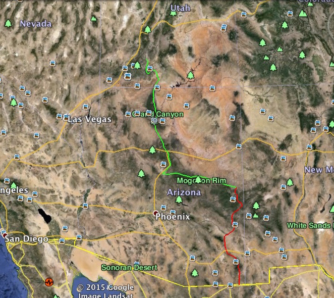
We started at the US/Mexico border about 18 miles east of Douglas, Arizona, near where Silver Creek crosses the border. It also happens to be where the monument to the Mormon Battalion stands.

Departure at the Monument for the Mormon Battalion

For those who don’t know the history of the Mormon Battalion, during the Mexican-American War (1846-1848), the whole membership of the Church of Jesus Christ of Latter-Day Saints, also known as Mormons, were making their exodus from Missouri and points east to the Salt Lake Valley, which was then in Mexican territory. Certain individuals in the US Government feared the Mormons were fleeing the United States, due to the persecution they had experienced in Missouri and the lack of any help or redress from the US Government, and that they would become Mexican citizens and fight against the US. The US Government sent forces to stop the Mormons from leaving the US, but once they actually met with representatives of the church, their fears were assuaged. Brigham Young called for volunteers to join the US forces to help fight against Mexico and drive them from the territories later claimed by the US, including most of the current southwestern United States. More than 500 volunteers joined what became known as the Mormon Battalion, leaving their families and friends to make their way west, trusting to the Lord and the other members of the church to care for them.

The Mormon Battalion trekked from Council Bluffs, Iowa to San Diego, California without a single hostile engagement, as Mexican forces fled southward. The battalion raised the first American flag over Tucson, Arizona, opened a southern route for future wagon trains bringing immigrants to New Mexico, Arizona, and California, and was instrumental in the settlement of much of the southwest of the United States of America. Former members of the Mormon Battalion were among the first discoverers of gold in California, which initiated the famous California gold rush.

There are several monuments in the southwest to the Mormon Battalion, and being Mormons ourselves, we felt fortunate to have started our trek at one of these historic sites.

I will mention here our gratitude to the US Border Patrol out of Douglas and Safford, for their assistance in getting permission from several ranchers for us to cross their range. Their help in selecting routes, obtaining permissions, and even guiding us through the Chiricahua Mountains was invaluable to us and to the success of our endeavor. During the first several days of our trip we were visited by their officers several times and were always provided with good information and help for our trip. They also kept us posted on any groups of illegal aliens and suspected drug traffickers they were monitoring, and helped us select routes that kept us out of harm’s way. I will provide more detailed information about their help in future posts.

Our route took us north from the US/Mex border, following Silver Creek to the Bar-M Ranch, where we turned more northeast, crossing US Highway 80 just west of Boss Ranch Road. We followed Boss Ranch Road, crossing Boss Ranch by permission of the owner, making camp in Half Moon Valley. From there we tracked northeastward, up past High Lonesome Spring to Texas Canyon Road. We followed Texas Canyon Road to Rucker Canyon Road ,which we followed northeast to North Fork.

Heading up North Fork Trail in the Chiricahuas

At North Fork we met with Joshua Jensen and Al Smith, who acted as our guides through the roughest part of the Chiricahuas and rode with us for three days. They took us up North Fork to the USFS lookout tower on Monte Vista Peak, then across the Crest Trail, and finally into Whitetail Canyon, through which we departed the Chiricahua Mountains. Both Josh and Al left us at Whitetail Canyon and Dad and I made our way northward to San Simon, where we crossed Interstate 10, passing underneath it traveling along San Simon Wash. We followed San Simon Wash northward toward Safford, until we had to leave it to find water for our horses. We ended up on a ranch road which took us past stock watering wells spaced about five miles, or so, apart and which led generally in the direction we needed to go. Thanks to Ron Mahan, of San Simon, for his help in selecting a favorable route through that dry desert area.

Nearing Safford, Az
Nearing Safford, Az

We made Safford on Thursday, April 23, which was about 3 days or so behind our planned schedule. We stopped at Joshua Jensen’s place, which he and his wife were gracious enough to allow us to use as a rest stop and re-supply station. While there we had Al Smith shoe our mule. Josh allowed us to use his pickup, so we headed into town for supplies. We also used the assistance of Al Smith to scout a suitable and safe route northward from Safford. With his help, as well as advice from the local Bureau of Land Management agents at the Safford office, we decided to avoid the problems and dangers of following the Gila and San Francisco Rivers, both of which are known to be choked with willows and are notoriously dangerous for livestock, due to quicksands. We determined to take a route that passed south of the Gila, skirting the Gila Box, passing south of Clifton by way of a power line service road and connecting with the Black Hills Scenic Byway. We crossed Highway 191 south of Clifton, then passed through Verde Lee and Loma Linda, finally hitting Rattlesnake Road, which took us into the mountains east of Clifton.

Rattlesnake Road eventually gave way to a USFS road which led up Rattlesnake Canyon to Rattlesnake Gap. This trail was, without any doubt, the steepest climb and roughest mile I have ever taken a horse over. It is one heck of a trail. Once over the top, though, it was a nice ride. I’ll detail that one later as well. I took a bit of video footage of it.

From Rattlesnake Gap, we followed the two-track ranch road, designated as USFS #215, I believe, which joined USFS #212 about 16 miles later, near Martinez Ranch, on the San Francisco River. We then followed the San Francisco west about two miles to the confluence of it and the Blue River, where we turned north to follow the Blue. The topo map showed that the canyon walls of the Blue, for the first two miles were pretty near sheer and quite narrow and that there would be no leaving the river bottom in that space. Not wanting to get trapped in a river bottom choked with willows, we took an old ranch trail out of the bottom up onto Sunflower Mesa. This turned out to be quite fortuitous, as we ended up finding a cowboy camp with a running spring, corral, and even a tent at Pat Corral on Pat Mesa. As it was Friday evening, the hands apparently had gone into town for the weekend. We spent a very comfortable camp night there. We left them a note, thanking them for the use of their camp. They responded through facebook, inviting us back for a visit. I hope we can make it one day. Thanks, Ruth Brockman and the crew from the Turkey Creek Ranch.

The following day we continued north on Pat Mesa, until we reached Pigeon Creek. There we were trying to make a choice whether to continue on the two-track we were following, which was rough and steep, or to go down Pigeon Creek to the Blue and follow the Blue up to Juan Miller Road. The route through the Blue would save us up to four miles, while the road was more sure. We decided to take the sure route and stick with the road.

As we came up out of Pigeon Creek, we met a hiker. As we talked, suddenly the both of us realized we had been in communication nearly 18 months earlier, through the Internet, about routes through this area. Brett Tucker owns the Grand Enchantment Trail website. He is a long-distance hiker who has documented a number of foot trails in New Mexico and Arizona. What a serendipitous coincidence that we would meet on this trail at this point. After talking a few minutes, Brett convinced us to head back down Pigeon Creek to the Blue and follow the Blue on up to Juan Miller Road. We did that, and soon found ourselves starting the most spectacular part of our ride. Thanks again, Brett.

IMG_1299The ride up the Blue was not an easy trail, because we were essentially making our own trail as we went. We found the occasional cow trail, but for the most part we were making our own way. However, surprisingly, the river bottom was neither choked, nor narrow. We had to do very little “brush-busting” to make our way through and the mile-and-a-bit to Juan Miller Road melted away pretty quickly.

Once we hit Juan Miller Road, the only east-west thoroughfare through this part of Arizona, we headed west to hit a four-wheel-drive-only two-track that follows the hills above the Blue northward for about three miles or so, to the Fritz Ranch, an abandoned historic ranch now owned by the USFS. From there we joined Blue Trail #101, which, if it actually existed, would have been a nice ride. However, the trail has not been maintained in many years and following it was impossible most of the time. It was more like following cow trails, and, in fact, probably was exactly that. Again, the river bottom was wide and we had to do little brush-busting. The trail was a little rough on the horses, due to having to follow the river bed at times, where the river rocks made footing uneven and tricky, but at least it was rather level.

About a half mile up the Blue from Fritz Ranch, we made camp Saturday evening and there we stayed for our Sunday rest. It was a nice camp, plenty of grass for the horses, and good water for us as well. We learned to cherish our Sunday rests. They were very important, not only for ourselves, but especially for our stock.

The following Monday we continued up the Blue, enjoying some spectacular scenery along the way. We made 26 miles that day and reached our rest station at the cabin of Dick and Jean Goodman, near the old Blue Post Office, long after dark. Dick and Jean treated us to some excellent rest and even better food. Dick made arrangements for our horses in the corrals of a neighbor. We rested again on Tuesday, which was sorely needed after the previous day’s ride.

Coming out of the Blue on Red Hills Road

On Wednesday we headed north again, on the Red Hills Road. We contemplated taking the Red Hills Trail, but after the Wallow Fire a few short years ago, the best information we had indicated the trails from the Blue to the top were un pretty poor condition, and we didn’t want to have to spend time hacking our way to the top, about 4,500 feet above the river bottom.

We reached the top in the late afternoon and made camp near a set of corrals just south of Beaverhead on highway 191. A friend had left us a bale of hay at the corrals, which was a welcome supplement to our horse feed, after such a hard climb. Thanks Jimmy Joy.

This was one of the nicest camps we made during the trip and we celebrated with a campfire, one of three we made during the entire trip (all our cooking was done on a single-burner propane stove). Our elevation was about 8,500 feet, as I recall. The following morning I was treated to watch about 8 elk pass calmly through the woods near our camp.

Camp at the corrals on Highway 191

From that camp, we followed USFS #26 Road for about 10 miles, where it dead-ended into #24 Road. We followed #24 north to #25J, where we took that road as a means of getting off #24, which is one of the main roads through the White Mountains of Arizona. We found a nice camp with a spring near by for the horses. The night was cold at over 9,000 feet, and we got rained on during the night. In the morning there was ice on our tarps. Still it was one of the nicest camps of our trip, meriting a campfire for the evening rest.

Out on top, White Mountains

The following day we made the remaining 22.5 miles into Eagar, arriving in the early evening before dark. We had pushed hard during the day, to outrun the weather moving in. We heard thunder and had a bit of snow fall on us. At over 9,000 feet elevation, cold weather is nothing to mess with. Our horses were tired as we made our way down into Eagar. We turned them loose in my 20 acre pasture for a well-deserved rest and headed to my parents’ home.

The first leg of the trip was over. By my GPS we traveled 355.2 miles. It took us 28 days – four weeks to the day.

Now for decision time.

This first leg of our Mexico-to-Canada pack trip was designed to be a “shake-out” for us. Our plan was to take our rest here in Eagar, evaluate ourselves, our horses, and our gear, then make decisions and adjustments for the rest of the trip. We hoped to continue our trip after a few days’ rest.

We learned a lot during this first 355 miles. We learned that we had grossly overestimated our travel miles per day and underestimated the miles of our route. We now know that 15 miles per day is a realistic figure to plan on. As for our route going forward, much of our travel will be on the Arizona Trail, which is fully documented for mileage, somewhat maintained, and planned out, and the roughest part of our trip is now behind us. However, we are currently more than seven days behind our projected schedule, which means our plans for crossing the Grand Canyon are not going to work out. I’m going to have to cancel the reservations at Mather Campground and reschedule.

We learned that my traveling companion, Clancy, my Blue Heeler, simply cannot make the miles. He’s good for a day or two, but he simply cannot make multiple days of 15-20 miles. I ended up having to carry him on my horse several days, which caused sore backs on my Fox Trotters. We ended up sending him home with my mother from Dick’s place on the Blue. Clancy will have to miss out on the rest of the trip.

We learned that at least two of our horses are not the right horses for this kind of pack trip. The Quarter Horse mare I borowed got saddle sores right off and no matter how lightly we loaded her, we could not get her over them. She’s going to have some healing to do. My Fox Trotter mare, Lizzy, has a very fast walk and she loves to really move out, which I love, but her motion as she walks causes our pack saddle rigging to rub sores on her. Once her back got sore while she was under my riding saddle, we couldn’t even pack her lightly, because the pack saddle rigging would rub her raw in places. We sent the two mares to my pasture in Eagar from Dick’s place on the Blue. Thanks Kelly LeSueur, for coming to pick them up.

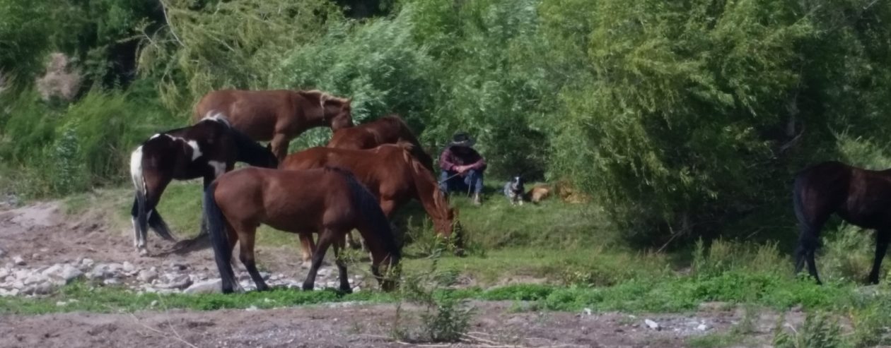
We learned that with four pack horses, there simply isn’t any way for us to break camp in the morning in less than 4 hours, costing us a lot of miles on the trail each day and a lot of extra work. While it was necessary for us to haul feed with us (we hauled up to 400 pounds of pelletized feed at a time) in the low desert areas of southern Arizona, once we got up into the higher latitudes and elevations, there was plenty of grass for the horses. We hope we can continue the trip with four horses, rather than six.

We had a couple of near disastrous wrecks during our trip, one of which eventually resulted in one of our best horses turning up with a limp the last 1/2 mile going into Eagar. Additionally, my two Fox Trotters have lost weight in their backs, which makes their already prominent spines contact the underside of my riding saddle, where the skirts are laced together under the cantle. They both currently have sore backs. The two animals who have come through entirely unscathed are my mustang, Jimbo, and the mule, Honey. Both have trimmed down and look like true athletes, solid and strong. These two are the only animals ready to start the second leg of our trip at this time.

As for ourselves, Dad and I both feel healthier, if a bit tired, now, than when we started. Both of us lost quite a bit of weight, and our muscles have begun to “leg-up” and become stronger. We have come through this with no injuries, no rubs, no health problems of any kind. Just tired. Nothing a rest won’t cure. You might recall that I am 56 years of age and Dad turns 81 in about 12 days. I am amazed at Dad’s condition and resilience. He says he’ll be ready for the second leg of the trip next year.

Lastly, this trip has cost me nearly $20,000 so far. Help and sponsorships I was hoping for didn’t come through. I am simply out of money.

All of the above factors, and others yet unmentioned, have brought us to the decision to stop here at Eagar, Arizona for this year and continue the trip next year.

This will allow us to make the necessary adjustments we have identified, such as acquiring a couple of horses that will be better suited for the trip, making a few minor changes in our gear, make better plans and reservations for crossing the Grand Canyon, and allow me to go back to work to pay off money I have borrowed for this trip as well as to put together a money reserve for next year’s trip. I have already purchased most of the gear we will need, so the funds required will be quite a bit less than for this leg of the trip, but I may still need to look for another horse or two. This is the wise course for us. This is what we need to do if we want to eventually complete this trek from Mexico to Canada.

Our thanks go out to all who have supported us, particularly those who have actually put out their time, efforts, and money to help us. We are grateful for all the prayers that have gone up in our behalf. We can say unequivocally that we received continual help from above, even miraculous help at times, and we thank the Lord for this.

I maintained a journal during the trip, so stay tuned for future posts with much more detailed information about our trip, out experiences, and reviews of the gear we used. I have a lot of video footage as well as a multitude of photographs, however the Internet connection at my parents’ home is somewhat slow. I may have to wait until I get home to Utah to get them uploaded.

What a trip! What an experience! Can’t wait for next year! The hardest part of the trip is now done.

Back to Planning the Big Pack Trip

To those of you who have been following this saga from the beginning, thank you. You will be pleased to know that Dad and I are actually in the “OK! We’re going to do this!” stage now. For those just joining us, my father and I have been trying to plan a horse pack trip from Mexcio to Canada. We have both been dreaming about something like this since I was in high school and we’re finally going to make it happen. We’ve had to scale our plans back a bit…a lot…because of a number of factors coming into play. The thought of making it all the way from Mexico to Canada is still rolling around in our heads, but we’ve decided it would be much wiser for us to break the trip up into “legs” and try not to bite off more than we can chew at a time.

Our hope for this year, 2015, is to take the first two legs of the trip, from the Mexican border to

The first two legs of our Mexico to Canada trip.

Panguitch, Utah. Shown in the graphic in red and green, as close as I can figure, using Google Earth and USFS maps, that will cover about 800-1,000 miles. I’m confident it will be closer to the 1,000 mile mark, since the Arizona Trail has been fully documented at 800 miles and our route through Arizona will be at least 100 miles longer than that, due to our desired stop in Eagar. We intend to document the trip by GPS, so there will be no question as to mileage and so anyone who wishes to follow our route later will have that information to help in their planning.

Truthfully, the second leg of the trip, from Eagar, Arizona to Panguitch, Utah, is the part of the trip Dad and I have been dreaming about. He and I have talked about crossing the Grand Canyon on our own stock for more years than I care to remember. From Eagar to Flagstaff, we’ll follow portions of the old Honeymoon Trail, which the early Mormon settlers of northeastern Arizona used to travel to be married in the LDS Temples in Utah. We’ll also travel the old General Crook Trail which he blazed from the White Mountains to Camp Verde in the late 1800s. We’ll then travel north on the Arizona Trail, crossing through the Grand Canyon, then on up through portions of southern Utah where my great-grandfathers used to ranch and run cattle. The legendary outlaw Butch Cassidy was known to have frequented the areas we’ll pass through. We’ll end up this leg, and likely our travels for the year, at Panguitch, Utah, where Dad was born and raised. This leg of the trip will be between 500 and 700 miles, as close as I can figure, and should take us about 6-7 weeks. Dad will turn 81 years old during that leg. There is a lot of history, both general and personal that we’ll be passing through on that part of our trip.

As of today, the plan is for us to depart sometime in April (a lot will depend on weather) and try the first leg of the trip. This will take us from the U.S./Mexico border just east of Douglas, Arizona, northward to Eagar, Arizona. That leg will be approximately 300 miles and should take us about three weeks, give or take a couple days. Eagar will be a sort of home-base for us, since that’s where my folks live. Once there, we’ll rest up for a week or two while we assess how we did and what we need to change. We will see how we feel about our horses, decide whether to add a couple to the string and whether any of the ones that made the first leg need to be changed-out. We’ll assess our gear – saddles, pack saddles, halters bridles, packs, cooking gear, etc. – and make adjustments where needed. Not among the least of things for a couple of old farts, we’ll assess our own health and determine whether our old bones can make the second leg of the trip.

First Leg To EagarTo add a little more detail, shown in the graphic in red, the first leg will have us departing from about Border Monument #77, just a couple miles east of Douglas, Arizona. We’ll track generally north from there, crossing State Highway 80 and on into the Chiricahua Mountains. As I will be taking my trusty trail dog with us, we’ll stay clear of the boundaries of the state park there, tracking around it on the east side. We’ll trend northwest from there, following portions of the Grand Enchantment Trail through the mountains until we come close to Safford, Arizona, where we’ll head east until we come to Eagle Creek. We’ll head north from there, passing east of the San Carlos Indian Reservation border, wind our way up to cross Highway 191, and head over into the Blue Wilderness Area. We’ll drop down off the Mogollon Rim and find Blue Road and follow it northeastward until we come to a friend’s place just south of the town of Blue. We’ll likely stay there a couple days and rest ourselves and the horses, before heading up Foote Creek Trail, or possibly Grant Creek Trail, back up on top of the Mogollon Rim near Hannagan Meadow. From there we’ll be tracking northwest, passing west of Alpine and Nutrioso and on up to Eagar, Arizona. That will be the end of the first leg, as I said before. As close as I can figure that should be very close to 300 miles.

That route for the first leg makes good sense for us, because it crosses roads at various places and passes through or near a couple of towns. That will make it a fairly simple matter for our logistical support. We already know we will have to pack our horse feed, or at the very least supplement it on this first leg. It’s not likely there will be much grass along that route at that time of the year. We will plan to have a driver meet us at planned locations to re-supply us with feed…for both horses and humans. From what I see on Google Earth, though, we should be fine on water for the stock and for ourselves all along the route that time of year, as there are numerous stock ponds and tanks and a few creeks. Snow run-off and rain should have them all pretty full.

After taking a couple weeks for rest and recuperation, as well as assessment and adjustment as necessary, there at Eagar, we hope to embark on the second leg – the trophy leg – of our trip. This route, shown in green in the graphic, will track northwest from Eagar, Arizona along the edge of the pine forests of the Tonto National Forest, to Show Low, Arizona. Just west of Show Low, we’ll meet the General Crook Trail, which is a designated trail for foot/equine travel. It will take us on down the mountains to Camp Verde, where we’ll join the Arizona Trail. The Arizona Trail will take us north, passing west of Flagstaff, Arizona (actually through Flagstaff for a short distance), then on

Second leg from Eagar, AZ to Panguitch, UT

north to the park entrance to the Grand Canyon National Park. We’ll stop there to make all the necessary last-minute arrangements with the park service and the mule outfitters before heading down the designated trails to the bottom.  While horse travel in the park is permitted on designated trails, coordination is necessary, so as not to encounter a string of mules coming the other way on a narrow portion of the trail. We’ll spend a night at the Ghost Ranch at the bottom of the canyon, to which I look forward with much anticipation. We could probably make it down and up in one day, but I can’t imagine making that passage without stopping for a night at the bottom of the Grand Canyon. That is something I have dreamed of. Sadly, my dog will have to travel this portion in the truck with the hired help.

From the Grand Canyon, we’ll move northward to cross U.S. Highway 89, where it makes a big jog as it crosses Paria Canyon. We’ll follow Paria northward to Willis Creek, which we will follow westward to the Grandview Trail. The trails up Paria and Willis Creek hold some spectacular scenery, winding through “slot-canyons” so narrow in some places that we’ll likely have to unpack our horses to pass through. The Grandview Trail wanders around the outskirts of Bryce Canyon National Park. It offers much of the same scenery, although from a less spectacular perspective, as the park does, but is on BLM land, which allows me to take my dog and is unregulated as far as horse travel. The Grandview Trail passes around the south end of Paunsaugunt Plateau (Bryce is on the southeast side of the plateau), then turns northward along the west side of the plateau. We’ll follow that trail up to Red Canyon, where we’ll come down off the plateau and make our way on into Panguitch, Utah.

We still have family living there in Panguitch, and Dad still has many old friends there. I expect we’ll be met there with open arms….and shaking heads. That will be the end of our trip for the year, completing the first two legs of our Mexico to Canada trip, covering about 800-1,000 miles.

It will also be the fulfillment of a long held dream for one son and his dad.

2013-04-29_13-28-33_320

Just Ruminatin’

Had a bit of a lazy day today. It was cold outside and not conducive to going out and getting anything done.  Or maybe I was just lazy.  I finally got up the gumption to go out to the workshop and piddle around.  I lit a good fire in my Virginian iron stove and looked around for something I could accomplish with not too much effort.  Funny how just accomplishing something…anything…can make you feel pretty good.  So, when I’m like this I just look for some little thing I can get done.  Sometimes it leads me to get something else done, and before you know it I’ve ruined a perfectly good lazy day and gotten some work done.

So, anyway, there I was in my shop, when I spied the farrier’s hoof stand I welded up last week.  Needed paint.  Well, it was too cold to paint.

My home made hoof stand

Better wait until it’s warmer…maybe April, or May.

Aw, hell.  I’ll just set it on the stove and let it get warmed up, and then I’ll paint it.

So it began.  I warmed up the stand, then warmed up a can of Rustoleum primer and a can of paint, and painted my hoof stand.  I left it sitting by the stove to dry.  Looks pretty good.  It’ll make folks think I know what I’m doing while I trim my horses’ hooves.

2013-01-11 13.27.51

Then I picked up a rifle and revolver that I had fun shooting a few times on New Year’s Day, and spent a few pleasant minutes cleaning them. It was kind of…I don’t know, meaningful in some way, I guess, that the rifle was a new, modern Ruger Model 77 in .17HMR, and the revolver was a copy of an old 1873 Colt .45 in a cowboy holster I made myself.  The old and the new. There’s probably some great, very impressive word, with deep meaning for that… but I can’t think of it.

So, what next? Well, there’s that block of wood I glued up last week for a pony saddle cantle. It needs to be cut out and carved to shape.  I guess I can do that.

So I put it on the workbench and marked out the pattern.  Then I carried it over to the band saw and eyeballed, checked, rechecked, then checked again, to make sure I had the angles right, then told myself, “What the heck? If I screw it up, I’ll just glue up another one!”

2013-01-03 23.10.03 (1024x768)

So, to cutting I went.  It actually turned out pretty well.  Sanded off the rough edges on the belt sander I have mounted upside-down on my workbench, and it looks pretty good.  Now I need to carve out the concavity of the seat with an angle grinder with a carbide carving blade…which I don’t have. I’ll have to pick one up tomorrow.

So, what next?  Hmmm.  Yep, there’s the cantle for the old “cactus saddle”, the Visalia I showed in my previous post. I still need to glue up the Poplar pieces for that.

Visalia cantle glued up

There we go. All clamped up and curing. It will be ready to cut and carve tomorrow.

I was so satisfied with myself that I sat in my soft chair by the warm stove, made an entry in my personal journal, and had a bite of chocolate.

hoofstandsmall

Nice day. Time for dinner.

What has been decided so far…

Here’s where things stand up to now with regard to my long ride in 2015.

The plan is for my buddy, Dale, and me to make the ride from March to about mid July, or whenever we get to Canada, 2015.  I had figured the mileage would be between 2,000 and 2,500 miles.  The mileage by road is about 1500 miles, as I recall, according to Google Maps. The Great Western Trail website, greatwesterntrail.org, says the trail includes 4455 miles of trails, however that includes the mileage for all the trails in the GWT trail system, not just one direct route.  Some sites indicate the mileage to be approximately 3,000 miles, but I have not yet found any indication of how they came to that number.  As far as I can tell, nobody has ridden the entire trail from Mexico to Canada in one shot.  I have found mention of several individuals who have ridden from either Canada to Mexico or Mexico to Canada, but through California, Oregon, Washington State, on the Pacific Rim Trail and not on the GWT.

The website for The Arizona Trail, which is the Arizona portion of the GWT, has a much better website. It has precisely detailed maps of the entire trail, including GPS data points, and information regarding trail conditions, regulations, etc.. They show the Arizona Trail to be 800 miles from Mexico to Utah. As a grand finale, of sorts, it passes through the Grand Canyon and ends near Jacob’s Lake at the Utah border.

There is a group of four young men, including Ben Masters,  who are currently gathering funds to make the trip in 2013.  You can find them under the name “Unbranded” on Kickstarter here. They are doing the ride to benefit the preservation of the American Mustang, a worthy cause, and to promote wilderness preservation.  They will actually be riding and packing mustangs purchased at auction from the Bureau of Land Management and trained by themselves.  They are currently seeking contributions for funding and are hoping to make a documentary film of it.  Look them up and lend a hand. I am looking forward to monitoring their progress to help with the planning of my own trip.  I have made contact with Ben via email.  He was very cordial and free with his help and advice. I plan to keep in contact with him and pick his brain and learn from his experience as much as possible.

I am currently in the early stages of gathering equipment for the trip. I am going to need a lot of new equipment, since my stuff has worn out over the past 40 years or so, less from use than from storage, while I moved around the country with my career.  I am going to need a new saddle, at least two pack saddles, all associated tack, new camp gear, and even new horses.

Right now I have a 7-8 year-old Quarter Horse mare I’m working with to see whether she has the makings of an excellent trail horse.  So far she’s doing fine.  I bought her about 18 months ago as a green-broke and have been slowly bringing her up.  Since I retired in March, I have been able to work with her regularly and have been able to get her training pretty much up to speed.

Problem is that there isn’t anywhere to ride out here in Virginia that even closely approximates thePenny trails I’ll be riding on the GWT.  I plan to get her out into the Shenandoah National Park several times this year to put some miles on her.  I’ve read there are over 180 miles of trails there, however, overnight camping with horses, it says in the regulations, “is allowed, but discouraged.”  Now what does that mean?  Do you set up camp and the park rangers come by to give you a hard time?  One rule says that if you can see your horse’s hoof prints on the trail, then you can’t ride on that trail and you must stay on the improved gravel trails.  What?!

So you see.  While there are places to ride out here in Virginia, it’s truly a different experience than out on the western trails.

I will need to purchase at least two pack animals in the coming year and get them trained up and ready.  I’ll need to get them out on some long, multi-day trails to get the kinks worked out of them.  I will also need to train them as saddle horses. No sense in having horses you can’t ride.

I plan to build my own saddle and pack saddles. This is something I have wanted to learn to do for many years. I particularly love antique saddles.  I love to see a brass horn and a tall shovel cantle. While I was visiting my parents in Arizona during November, my dad gave me an old saddle he has had in his workshop for many years. He can’t even recall where he got it. He called it his “cactus saddle”. It didn’t look like much. The only leather left on it was the pommel cover. The rawhide on the tree had been cut away in places, as repairs were made to the tree. I stripped off the leather and rawhide and took the tree completely apart and found the cantle and fork broken and the bars badly damaged. The brass horn is a little bent, but not bad. I found the remnants of rawhide braid around the base of the horn, evidence that the brass horn was hidden under braided rawhide. I was surprised to find hidden under the rawhide on the top of the seat-side of the cantle, a label that said “Visalia”.  I expect this saddle was once a Walker Visalia saddle, which would have been very collectable.

I have since repaired the cantle and fork and am in the process of repairing the bars. Since old saddles don’t fit modern horses very well (we like our horses big and fat, while horses back in “the day” were generally trim and fit), so I recut the angles on the fork to give the bars a more modern angle, of about 90 degrees.  I also re-cut the cantle angles to make it fit the new bar angle.  It now has what might be considered “semi-Quarter Horse” bars.

I temporarily assembled the tree with the new bar angle and tested the fit on my mare, who has low withers and a broad, flat back.  It still fit a little narrow for her.  I have the use of a 22 year-old Quarter Horse, who looks more like about 16, so I tried it on him.  The tree with the new bar angles fits him like a custom-made saddle.

So, now the plan is to duplicate the saddle tree and cut the bar angle on the duplicate to fit my mare, then build both saddles. I will have a saddle to fit my mare with full-Quarter Horse bars, or thereabouts, and another saddle to fit horses with taller withers and narrower, sloped backs. The saddle I build for my mare will be the saddle I ride on my trip.

Incidentally, I am also rebuilding a pony saddle in the same way.  The original belonged to my brother-in-law, but was in less than restorable condition.  I have disassembled it and am in the process of duplicating the tree.  I will build the pony saddles before I start my saddle. I hope it gives me the necessary experience to do a decent job on a good work saddle for myself.  It certainly won’t be a show saddle, but functionality and a look that won’t embarrass me are what I’m aiming for.

Sometime in the next month I will order leather and start the saddle projects. I will also make myself a set or two of good leather saddle bags.  I actually prefer canvas saddle bags, but I haven’t been able to find a good pair recently.  Everybody seems to have gone to nylon and cordura. I’ll try a leather set and see how I like them.

My dad has a couple of pack saddles he would let me use for my trip, but I think I’ll go ahead and build a set for myself. I have always used the crossbuck style packsaddles, so I expect that’s what I’ll stick with. I have no opinion as to whether the crossbuck style or the Decker style is better, I just like the crossbuck style. It’s just what I grew up with, I guess. I’ll use Dad’s pack saddles for patterns for both the trees and rigging.

I still have just over two years to get all this done, but I expect to get the saddle gear done this year, so I can start using it and getting all the kinks worked out of the horses.  If any of the horses were to prove too much of a knothead for the trip (remember, I’ll be going through the Grand Canyon and they’ll have to go through a tunnel and cross that long suspension bridge at the bottom!), I’ll have to have time to sell it and get another and get it worked out before the trip.

Lots to do.  I get excited just thinking about it.

Ben Masters and friends, good luck to you in your endeavor.  I just sent you a small donation.  I’ll keep up on your progress.