
A couple weeks ago I got an unexpected text from a friend. It said something like, “Heading up to the Bob Marshall. Want to go?”
I responded, “When?”
He said, “Next week!”
I started cancelling things and moving appointments.
Our group consisted of Derek Habel, our host, his granddaughter, Kami Painter, his good friend, Jeff Palmer, and myself. Derek’s brother, Allen, joined us at the trailhead. I was the outsider, but a horse pack trip has a way of bringing folks together in a way few other activities can do. By the end of the trip we were all good friends.
 Our horses were Missouri Fox Trotters, preferred by us for their smooth fast gait, sure-footedness on uneven terrain, and their even temperament. It’s a beautiful thing to watch a string of Fox Trotters moving along a trial at six or seven miles per hour. It’s even better to be riding one of them.
We started our pack trip at the Loop Trail trailhead on Friday morning. The trailhead can be found by taking Benchmark Road west out of Augusta, Montana (check a map for mileage). Just past the airstrip, you’ll find a large overflow parking area. Plenty of room for even large rigs. There is a corral there, but the outfitters normally have that. There is plenty of room and plenty of grass for primitive camping. Go on to the end of the road and you’ll find a designated camping area that has several horse camps with tie racks, feeders, and room to back in a decent sized stock or LQ trailer.
 Our original intent was to make the loop on the Loop Trail, which loops around the famous Chinese Wall, then back to the main trail. We didn’t make it, so I can’t report on the entire trail.
We made it out about twelve miles, before our new pack horse gave out. She was a new acquisition for Derek and she just wasn’t in condition to carry a 200 lb pack. So, we adapted. We made a base camp just off the trail near a creek, just about two miles past the USFS Ranger Cabin.
There was very little grass there at camp, so it was a good thing we had packed in about 100 lbs of pelletized feed for the horses. Water was no problem, for horses or people.
 We packed in a pair of bear-resistant panniers, so we were in compliance with the rules for “The Bob.” This is bear country, both black and grizzly, so pay attention to the food storage rules, or you may be very sorry. Besides, not paying attention to the rules can get you a citation from the rangers.
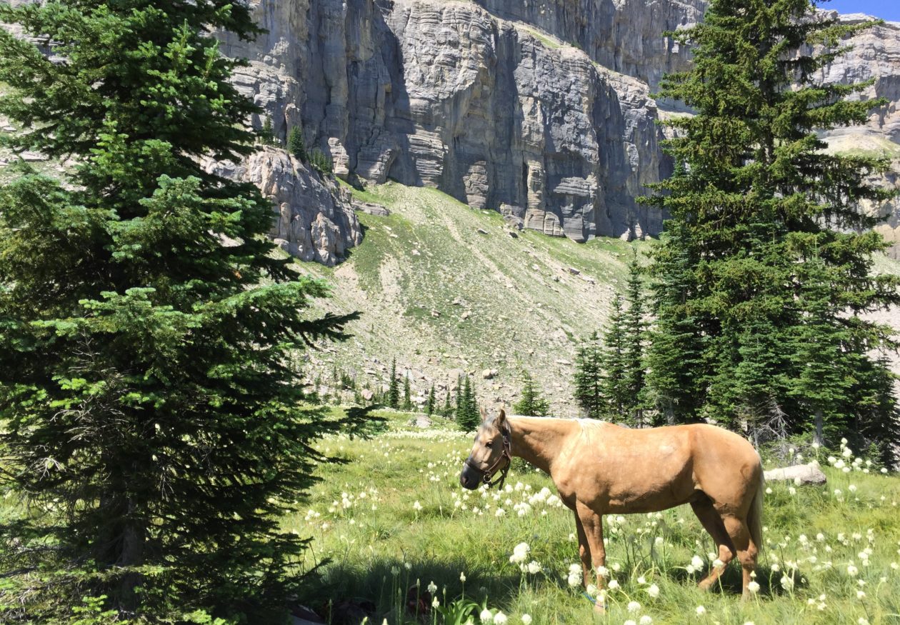
The following morning we decided to leave the pack horses in camp and make an in-and-out ride up to see the Chinese Wall. What a nice ride it was with spectacular views. The wildflowers were out adding a wondrous array of color against the green foliage. Bear grass blooms into large white fuzzy-looking puffballs on a long stem. I’ve been told it blooms only once every four years. This was a bloom year and it was beautiful, adding an accent of white in every meadow along the way.
 We came to a nice pass with an excellent view of the entire Chinese Wall, where we unsaddled and had lunch. The mileage from camp was 9.6, according to my GPS.
As we glassed the Chinese Wall we were privileged to see a couple nice billy mountain goats.
 After a lunch and a good nap, we saddled up and headed back. It’s amazing how the views going back are just as spectacular as coming in.
Just before we arrived back at camp, we noticed smoke in the valley near the river. While we rode on into camp, Allen detoured to check out the source of the smoke. As it turned out, an old rotting log had caught fire by spontaneous combustion – no lightning, no sign of a camp, just caught fire due to the extreme heat and a little rain a couple nights before. We spent the rest of the afternoon putting it out. Luckily, we happened on the scene and only about 800 or so square feet was charred. Could have been much worse.
The next day we took things pretty easy. We needed to move camp, but our lame pack horse was barely moving. She had some pretty sore feet. Late in the afternoon we decided to move our camp about two miles, back to the ranger cabin, where there was plenty of grass and water. We put a set of boots on the mare and packed her light. At her own speed and she made the move just fine.
 That night the temperatures dropped and I awoke with frost on my sleeping bag and me wishing I had brought my winter bag instead. Even in the middle of July, it can get cold in the Bob.
The following day we made another in-and-out up to White River Pass. My horse had thrown both front shoes by then, so I saddled up Derek’s other pack horse. The trail was good, although there are a couple places that might make some folks shiver. The view from the pass was phenomenal. In every direction lay another panorama of mountains and valleys. I forgot to turn my GPS on, but I reckon it was about a ten-mile ride up to the saddle. Again, coming back down the trail was a beautiful as going up. We stopped for a few photographs in the spray of a small waterfall.
We got back to camp fairly early in the afternoon, so we decided to head back to the trailer and get home a day or two earlier than expected. I suggested that since my horse had now lost a third shoe (remember the short notice I had to prepare for this trip? It caught up with me) and was tender, I might take him and the lame mare and head on out while they packed up camp, figuring that if I were lucky we might make it back to the truck only slightly behind the rest.
Once the mare got to walking, she loosened up a bit and seemed to be fine. I let my gelding and the mare choose their own speed. What a pleasant ride it was! Just me, all alone with the horses. To me, that’s what it’s all about – my relationship with my horses. I talked to the horses, whistled, and even sang out loud at the top of my voice. There was nobody but my horses to hear, and they seemed to enjoy the ride as much as I did.
All-in-all, we did about 65 miles total, through some of the most beautiful landscape on God’s green earth. What a pleasant trip it was!
 The Bob Marshall should be on everybody’s horse bucket list.

 Since both Jon and I were taking only one horse each, and since he lives up north and had to pass by my way anyhow, I threw in with him. He picked up me, my horse, and gear on Thursday afternoon about 2:15. We enjoyed a comfortable ride down in his nice rig and arrived at our destination sometime around 7:00 pm or so. We met the rest of our gang on private property that adjoins Capitol Reef, of which the owner is a member of the UMFTA.
 I had brought my new horse, J Golden, figuring this would be an excellent training opportunity. This was officially his sixth and seventh rides, so he was pretty green, but hadn’t given me any trouble so far. Well, he was excited to see all the new horses and people and to be in a new place. As I tried to mount, he began fidgeting around. I reined him in on the left side and turned him a couple times, trying to get his mind on his business and to stand still, so I could mount. I thought I had him in check, so I pulled myself up. As I was swinging my leg over the saddle, however, J moved into me, which caused me to be over-balanced to the off-side. My right leg swung over as I hung on and I inadvertently jabbed him in the side with my spur. Well, J felt that jab, and not knowing what had happened, and with all the excitement, he immediately launched into a full-fledged bucking spree.
 We spent a nice, relaxed evening back at camp, where our group all pitched in for a nice camp dinner. I took the opportunity to see how J would do with hobbles. I was pleasantly surprised to find that he reacted very little and the experience was pretty much a “yawner.”


You must be logged in to post a comment.