Tag Archives: Clifton

Days 20-23…From the Gila Box to the Blue Range Primitive Area…Second Edition

This post will cover Days 20-23 of our pack trip last year.

Day 19 left us camped out on a hilltop overlooking the Phelps-Dodge mine at Morenci, Arizona, just north of the northeast end of the Gila Box Conservation Area. We were only about a mile or so west of US 191, just south of Clifton. Our route this day would take us east for several miles, then northward toward the southern part of the Blue Range Primitive area. This day would see the last of the harsh terrain and conditions of the low Arizona desert and start putting us into the higher, greener elevations.

On Day 20, April 30, 2015, we arose early, as always, fed the horses, rolled up our beds, had breakfast, and hit the trail again. We hit US 191 before 10:00am. Our first challenge of the day. The State of Arizona, or maybe the Bureau of Land Management, made this very nice gate there at the cattle guard at the approach to the crossing. Problem was, the gate would not open. The bottom foot or so was buried in sand. Took me about a half hour to dig it out, so we could open it far enough to get the horses through.

Lunchtime and a rest

After that, we crossed the highway and rode the shoulder for about a quarter mile north to join Table Top Road, which took us north, then turned southeast for several miles to a small township, of which I cannot recall the name. It was more like a housing development than a town. As we entered the town, we found a small grassy spot near a diversion dam, where we let the horses graze for an hour while we had lunch and rested in the shade of a tree. It was a good stop for us, because little did we know what was waiting for us.

After passing through another small township, on Ward Canyon Road, we turned northeast on Skyline View Road, then took a right on Rattlesnake Road. Rattlesnake Road was a dirt road that headed northeast toward the mountains. The terrain we had been passing through up to this point was regular old Arizona desert. Very little vegetation, other than greasewood and the occasional mesquite tree. The rocky ground was not quite as bad as what he passed through the previous two days, but it was still rough. It was nice to have a dirt road going in the direction we needed. After several more miles we came to the end of the road. Well, at least the maintained road. We found ourselves coming to a USFS road that obviously hadn’t been maintained in a while. We could see it stretching before us, climbing straight up a narrow, very steep canyon. Rattlesnake Canyon.

From the top of Rattlesnake Canyon

Luckily, there was a good waterhole at the foot of the road, where we watered the horses. We were joined there by a herd of horses. I doubt they were mustangs, but they were pretty wild. The road was extremely rocky, but at least it wasn’t all volcanic rock. The canyon was scenic, but the climb was so steep we didn’t get to look around a lot. I recorded a short clip or two on my iphone, but the battery started to go, so about half way up the canyon I got my GoPro out and tried to get a couple more clips.

We climbed 1200 feet in under a mile. We had to stop a number of times to rest the horses. By the time we crested the saddle at the top of the canyon, we were resting the horses every 100 yards or so. We got a good laugh as we came to the last hairpin turn before the crest. There was a “dangerous curve” sign just after the turn, on the high side. Yep. Big as life, a real live Arizona road sign. I can tell you that even a rock climbing Jeep, or a 4-wheeler, for that matter, would think twice before tackling that road! Lucky for us, our horse feed was running low, so our horses were packed lightly.

This day I rode Ranger and Dad rode Jimbo. Daisy was again developing saddle sores on her withers and Lizzy had a sore back. Lizzy had started developing a lump on her back, about where my saddle cantle rode, on Wednesday. I suspected there were two factors involved: my having to carry Clancy in the saddle for much of the day on Wednesday and the fact that she had started to drop a little weight, which made her already prominent spine (Fox Trotters are built that way) even more prominent, which caused the saddle to put pressure there.  I had given her a helping of bute with her morning feeding and she was packed very lightly. The pack saddle allowed her to move with no pressure on her sore spot. I hoped that would help.

Clancy was making work of things. His paws were very sore and his strength wasn’t recovering with a night’s rest as he had early in the trip. He was simply wearing down. On this day I carried him most of the day on my saddle on Ranger.

The pond at the top of Rattlesnake

We took a short break at the top, looked around, rested the horses, then headed on down the road. The descent on the other side was not steep, but quite gradual. It was also treed with oak, juniper, and cedar. There was grass and other vegetation. It was a completely different world that the other side of the hill. After a short distance we came to a small pond with an old line cabin. We watered the horses there, but didn’t stop long. We had to make several more miles before we could stop for camp.

I don’t know whose ranch land we were passing through (I’m sure it was BLM range), but I can tell you they had some good cowboys. This land was very well maintained, with well-maintained stock ponds every mile or so. We saw evidence at every turn of hard work having been put into keeping up that range over many years. What a beautiful ranch it was.

Just before sunset we came upon a stock pond with a very nice corral. There were nice trees and a perfect level spot for camp. Problem was that there was this huge black angus bull occupying the campsite. Eventually we were able to crowd him off our selected spot, but he stayed close by all night. Seemed like he liked the company. We watered the horses, then released them into the corral. They enjoyed the freedom of not being tied and all had a good roll. We enjoyed our camp that evening, although we were beat, having made 16.4 miles.

After a short night, we were up again at sunrise. We were packed and moving by 9:00 am. Our goal for the day was to pass the Martinez Ranch, on the San Francisco River, about a couple miles from the confluence with the Blue River, start up the Blue, then camp at a stock tank on Pat Mesa. After that, we would head north on the Blue, entering the Blue Wilderness Area. We had a stopover planned at a friend’s place at Blue, Arizona, which we believed we would reach by Sunday. Turned out that was very optimistic. We hoped to be able to have someone meet us there to take Clancy back to Eagar with them. He was having a hard time of it.

We enjoyed Day 21. As I said, we passed through some very nice ranch land. We passed through rolling hills for most of the day, and the weather was pleasant. We passed the Martinez Ranch just before lunchtime. It didn’t look like there was anybody around, so we kept going. We rode down to the San Francisco River, watered the horses, then let them graze for an hour. We had our lunch there and refilled our canteens. That was about the 250-mile mark on our journey.

From there we followed the river west for about two miles, to the confluence of the Blue River. These were tough miles, during which we crossed the river six times. One crossing was deep enough to come up over my boot tops, but not deep enough to flood our pack paniers. The trail along the river had not been maintained, so it was difficult to follow, however we were again blessed.  A four-wheeler had passed through not many days before us (judging by the tracks) and the rider had marked the trail with ribbons. Without that, we would have had a very difficult time finding our way those two miles.

At the confluence of the Blue, we turned north to follow it. The Blue River bed was much wider and more spread-out than the San Francisco. It was quite beautiful and was much easier traveling.  We followed the river for a quarter mile or so, but saw that it was coming from a very narrow canyon. The map showed that if we entered that canyon we’d be stuck in it for several miles before it spread out. Not knowing what we might find in there and being concerned about quick sand and the thick willows growing along the banks, and just having bushwhacked along the San Francisco for two miles, we elected to seek a route up out of the canyon and to keep to the mesa until we reached Juan Miller Road the next day.

Our 1967 USGS map showed a trail that ascended up out of the canyon where we were, but our current topo map did not show it. We searched around a bit, expecting that the trail was not maintained anymore. We finally came upon it and found the USFS or BLM had plowed it up and put up berms to keep it from being used. Lucky for us they did, or we would never have been able to follow the trail! Had they just left it alone, it would have grown over and disappeared, but their efforts to close the trail by placing a berm in it every twenty yards or so, guided us up the steep trail until we reached the top at Pat Mesa. By this time, Dad and I were bushed, as were the horses. The last three or four miles had been tough ones.  We began looking for a camp, still about three or four miles short of our goal.

We saw a stock tank on the map, which gave us hope, but when we reached it, it was dry. We continued on, thinking we would be making a dry camp. We finally came upon a suitable place, with a small clearing among cedar and juniper trees, but as we were about to dismount, I noticed across a canyon that a two-track road turned up into the mouth of a canyon. At the mouth of the canyon I could see some sort of structure. I told Dad I thought it might indicate a water source, as I could think of no other reason for a road and a structure out in this area. It was only about two more miles to round the head of the canyon and cross over, so we continued.

Lucky we did, because we came upon an improved and running spring, with a cowboy camp and a corral. Apparently it was a working camp, but every body had headed to town for the weekend (it was Friday evening). We imposed ourselves on their hospitality and set up camp, tossing our sleeping bags in their tent. It was nice and we slept well. We left them a “thank you” note and let them know we left the camp like we found it. Ruth Brockman, of the Turkey Creek Ranch, sent me an email later, saying she had received my note and were glad we had made ourselves comfortable. She invited us back for a visit whenever we get back down that way. I’d like to do that sometime.  We made 16 miles that Day.

Saturday, May 2, Day 22, was more of the same, traveling across Pat Mesa, following a “cat track” that was used as a ranch road. Again, we saw much evidence of hard work being put it to maintain the range and keep it in good condition, which it was. The road was fairly easy until we got a couple miles short of Juan Miller Road, at which point it became very hilly and rocky. It became a lot of work on the horses. That’s one problem with following a “cat track”. They are named that, because they are bulldozed out of the mountains. Bulldozers are nicknamed Cats, after the company Caterpillar. Cats don’t necessarily take the easy route and don’t make many switchbacks. When they do, you know it’s a steep hillside.

We had just descended down into Pigeon Creek and were looking at two options: we could turn east about a quarter mile and strike the Blue River, following it upstream for less than two miles to Juan Miller Road, or we could stick with the cat track for another 4 miles to get there. We were still leery of following the river, so we decided to go with the known-quantity and continue on the cat track. We climbed the very steep ascent out of Pigeon Creek and were just cresting out when we came upon a hiker. We stopped and talked to him for a few minutes. It took me about two minutes to recognize him as a man with whom I had communicated online about two years before regarding possible routes for us through these mountains. What are the chances?

Brett Tucker is a long-distance hiker, who knows southeastern Arizona like the back of his hand. He has the website “Grand Enchantment Trail“, which documents a long-distance trail he designed through several mountain ranges in southeastern Arizona. He just happened to be out scouting a new route for a trail. Much of the route I selected for our trip was based on his advice. Once I realized who he was (he recognized me at about the same time) we asked his advice for our route to Juan Miller Road. He suggested that we turn around and head down Pigeon Creek to the Blue and follow it. He assured us it was a safe, easy, and scenic passage for horses. We followed along with him until we reached the Blue, at which point we said our goodbyes and he turned south while we went north.

Incidentally, after we finished the trip, Brett sent me an email. He said he returned to Juan Miller road via the cat track. When he reached the road he found the gate locked. Our passage would have been blocked. What a disappointment that would have been for us.  Another of those simple little “tender mercies” of the Lord to help us along on our trip.

And thus began the most pleasant part of our trip, traveling up the Blue River to Blue, then up Red Hills Road and over the top to Eagar.

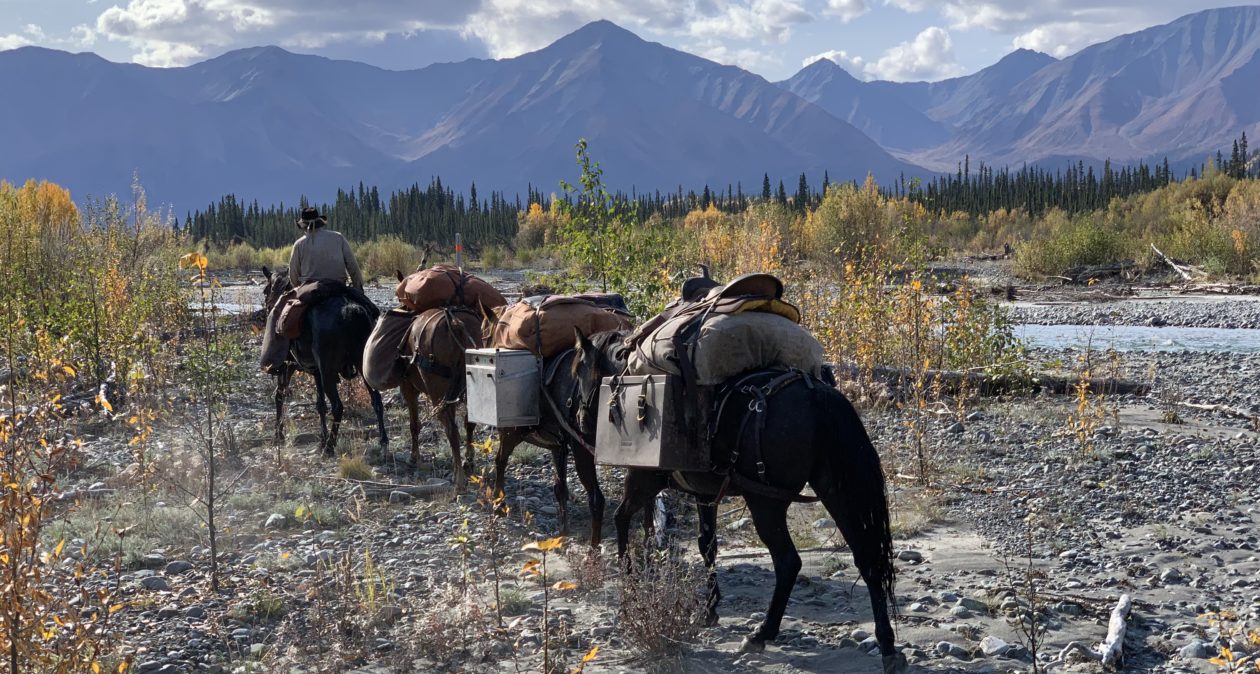
We headed up the Blue then, crossing back and forth across the crystal clear water about ankle deep most of the time. Cottonwood trees grow along the banks and willows are thick in many places, but we were always able to find a decent way through. In some places the cliff walls became very tall, imposing, and beautiful. There were places where the river passed through narrow cracks in the cliff walls, and we passed through in the river. Travel wasn’t easy, but it was pleasant. We made the short couple miles to Juan Miller Road, then headed west until we found a two-track designated 4-wheel-drive road that headed north. That road took us to the historic Fritz Ranch, now a USFS property. We took Blue Trail #101, which heads there at Fritz Ranch. The trail follows the Blue River all the way to Blue Road, and that was our plan. We planned to make camp about 6 miles or so up the trail at the HU-Bar Ranch, which is an old abandoned ranch house, used by many passers-by as a camp stop.

This day I was riding Daisy. I had both Ranger and Lizzy under pack. Turned out that Ranger showed a sore back the night before. Had to be from carrying Clancy in the saddle. Not only that, but holding Clancy in my lap caused me to sit back farther in the saddle and caused me some back strain. I was developing a very painful knot in my upper back.

The days on the trail, through very difficult country, had taken its toll on us. Dad and I had found ourselves becoming increasingly short-tempered with ourselves, with each other, and with our horses. We were tired, the horses were tired, Clancy was tired…we were just beat. It was Saturday afternoon and we were looking forward to a much-needed Sunday rest.

No more than about 1/2 mile up Blue Trail #101, one of the horses started acting up a little and I was getting angry at him. My anger was spreading through the whole bunch of us pretty quickly. Suddenly, I looked around us and saw that we were in a pretty decent place for a camp. I turned to Dad and said, “We’re camping right here tonight!” We were about five or six miles short of our goal for the day, but we were done. We made camp right there. We made 17.2 miles that day, 273 total miles on the trip.

We didn’t spend a lot of time with things that afternoon. We simply cared for the horses and staked them out on the plentiful grass, then went to work setting up our camp. We had a couple hours before sunset, so we just rested and relaxed while the horses grazed. Turned out this was a good decision and we were camped in a pleasant spot.

On Sunday morning we stayed in bed a little longer than usual. The weather was pleasant, the morning cool, and we were comfortable. After we arose, we fed the horses a bit and moved them to new areas to graze. We found that Black was a bit lame. Both his rear fetlocks were quite swollen. We gave him some bute with the feed and hoped that rest and some prayers would have him ready to go again the following day.

Lizzy and Ranger seemed to be doing better. Their backs were much better. Daisy’s saddle sores were getting worse, though. Nothing we could do about it. We had taken it as easy on Daisy as we could, to the detriment of the other horses. All we could do was to keep salve on them to keep them soft and lubricated. Clancy was doing a little better, after having been hauled in my saddle for much of the previous day. Dad and I were losing weight quite rapidly. The miles were showing on all of us, except Jimbo the mustang and Honey the mule. They seemed impervious to all the travel and work. They looked just about like they did when we started the trip 23 days before. Not a mark on them.

We had learned by now that our herd of horses…and one silly mule…would follow Ranger about wherever he went, but that Lizzy was the Queen Bee of the herd. Ranger would generally stay where she was and the rest would hang around Ranger. We had also learned that Lizzy tended not to stay in one place very long. She would graze for a couple minutes in one place, then walk off 20-30 feet and start again, which kept our whole herd moving constantly. We found that if we staked Lizzy the rest of the horses would settle down and graze lazily in the same general area. So, that’s what we did for Sunday. I tied Lizzy and moved her to a new spot every couple hours and the rest of the herd stayed around in the general area, calm and relaxed.

I went down to the river to wash clothes and take a bath. It was…refreshing, to say the least! While I was down at the river, I suddenly heard a whinney from way down the canyon, maybe a quarter mile, then an answer from Lizzy, tied there at the edge of camp. Suddenly there was the drum of hooves at full gallop rushing toward camp. I got to where I could see, just in time to watch our entire herd run full speed through camp! Luckily, they stayed mostly to the trail and didn’t actually run over our camp. They stopped immediately after passing through camp, turned around and came back to see Lizzy. Then they all settled down to grazing calmly again.

Dad and I passed a particularly lazy and restful day. The horses and Clancy did the same. We were all healing and resting our tired bodies and minds. The horses seemed to particularly enjoy the day off. A fresh bath put me in a very restful and relaxed mood. We all felt pretty good. It was a good day.

That night, Dad and I were sound asleep, sleeping very well indeed, when I was awakened by a whinney way off in the distance, then an answer from Lizzy, tied right there at the edge of camp…OH NO!!!!!

Stay tuned for the last five days of our wonderful horse packing adventure in my next post.

P.S.

I have discovered a work-around to fix my upside-down photos on the posts. Eventually I’ll go back and repair the older posts. Thanks for your patience.


Day 19, Double C Ranch to Clifton

Day 19 for us was a difficult one for us. On this day we came very close to having to put a horse down.

We made camp the night before at a waterhole near the Double C Ranch, in the Black Hills, between Clifton and Safford, Arizona. This area is extremely rough terrain, not so much in the form of canyons and mountains, but in the form of volcanic rock for ground cover. We were lucky to have been able to follow a power line service road through the mountain behind us, because cross country travel would have been nearly impossible on horses. In fact, we had to leave the road once, as we made our way to a cattle watering trough and found it to be extremely slow and careful going. Had we not re-shod the horses the day before, we would have been in real trouble.

On the Black Hills Scenic Byway

On Day 19, however, we were on a dirt road, the old Clifton Highway, now known as the Black Hills Scenic Byway. It is a well-maintained road with little traffic, but it winds up and down and round and round through the Black Hills and seems to go on forever. We found several stock watering tanks, however, so that was nice. We had to watch those, though, because several of them were infested with bees. I’m pretty sure Ranger got a sting on the nose while drinking at one, because he has been scared of metal troughs ever since.

Several miles up the road, a fellow stopped to talk. He was Rocky Menuz, who owns the Double C Ranch. We had elected not to ride up to his ranch the night before, not wanting to bother anyone. It seems some of the ranchers are leery of strange horses, because of communicable equine diseases. Rocky, however, was disappointed we hadn’t called on him. He is a former municipal judge in Clifton. He was raised in the area, his father having founded the ranch many years ago. He knows everybody. What a nice man. He invited us to come back and visit him. He also told us where we would find water along our route.

Grazing in the Gila Box

We finally descended out of the east side of the mountains in the early afternoon. As we reached the valley floor, the terrain softened and we found a very nice grass pasture. We took a lunch break and let the horses graze for an hour or so. It was a nice rest for all of us.

A few hundred feet farther along, we entered the Gila Box Conservation Area. We continued on down the road and came to a ranch a short distance from the Gila River. We met Mr. Menges, who owns the ranch. He gave us some directions for our passage across Highway 191 and on up into the mountains east of Clifton. Turns out there just wasn’t any way to cross that area by trails. We were going to be following dirt roads until we got up into the mountains again. As it was getting late in the day, we asked about water and places to camp on up the road a few miles. He gave us directions to one of his stock tanks a few miles farther up and gave us permission to camp there. He said there was a large covered water tank there, with an access hole on one side, through which we would be able to get clean water for our canteens.  We thanked him and headed on down the road.

Another mile along, we came to a cattle guard on the road where the road was cut out of a sidehill. The stock gate was on the downhill side, where the sidehill had been washed out by the water running through the cattle guard. It was Dad’s turn to get the gate, so he dismounted and led “that stupid mare”, Daisy, through, with his gelding, Black, and the mule, Honey, following. They made it through with no trouble, after a short scramble back up to the road. As I came through, leading Ranger and Jimbo, however, Ranger’s right side pack hit the gatepost, causing him to stumble and nearly go down in the washout. He scrambled back up, but he had Jimbo pigtailed to his pack. About the time he started scrambling, Jimbo’s pack also hit the gatepost and down he went with Ranger tugging on his lead. Jimbo scrambled back to his feet and made it back up to the road, but his pack saddle was listing a bit to the left and his saddle pad was sliding out the back.

About 50 yards down the road we stopped to re-settle Jimbo’s pack. With nothing to tie to, I just dropped the leads of Lizzy and Ranger and went back to work on Jimbo. Dad dismounted from Daisy and tied her to a nearby road sign, with Black and Honey tied to her. Dad and I dropped the packs from Jimbo’s pack saddle and had just started to work on his pack saddle, when all hell broke loose.

That stupid mare, Daisy, trying to grab some grass, tugged on her lead, which was tied to the road sign. That caused the road sign to rock back and forth. Daisy must have thought that sign was about to get her, because she pulled back, pulling the sign right out of the ground! When that happened, Jimbo spooked and started to run down the road away from the ruckus, taking Lizzy and Ranger with him. Meanwhile, that stupid mare was backing right toward the steep sidehill, dragging Black and Honey with him.

I let my horses go and started after Daisy. I tried to calm her as I chased her, but the faster I ran, the faster she backed away. Keep in mind that she was dragging the road sign along in front of her as she backed down the road and it was banging her front legs, with two scared pack animals in tow. Once she realized she was about to back off a near cliff, she corrected and started to back straight down the road…right toward the cattle guard. It didn’t take me long to realize I wasn’t going to catch up with her before the three horses hit the cattle guard.

At that point I did the only thing I could do. I dropped into a crouch and prayed, “Oh Lord, please help us!”

I watched in horror as Daisy backed Black and Honey right out onto the cattle guard. I was amazed to see that both Black and Honey were actually standing on the cattle guard and hadn’t fallen through. Daisy had backed one rear hoof onto the cattle guard, and it went through, so she pulled it back out and stopped. I caught her then, grabbing her lead rope and pulling her forward to allow Black and Honey to move off the cattle guard.

I was able to get her to move forward just a step or two, which allowed Black to move forward. He took one step and his front right went through. He jerked it up, but his right rear slipped through the cattle guard. By this time he had both fronts on solid ground. He jerked his right rear up and out and immediately his left rear slipped through the last rail. He lunged forward and fell. He just laid there. I was absolutely certain he had broken his leg.

By that time, Dad caught up with us. I told him, while I worked to untie the sign from Daisy’s lead rope, that I was afraid Black had broken his leg and we would have to put him down. Suddenly, Black lunged to his feet, standing on all fours. He came up with his head under the hind quarters of Daisy, with his lead rope all wrapped around her, nearly lifting her off the ground. We scrambled to free the lead ropes and get the dang road sign out of the way, and were able to allow Black to slip out from under Daisy.

All three were shaken and upset, but it appeared there were no serious injuries. What a relief. We carefully inspected all three animals and found that Daisy had a scrape on her leg and a cut on the back of her left rear hoof, where she had jerked her hoof out of the cattle guard. Black had similar scrapes and cuts on both his rear hooves, but none of these were serious enough for concern. Black, however, was favoring his left rear and it appeared he had twisted his fetlock joint. It immediately started to swell, but he could walk on it.

Meanwhile, in all this confusion, Honey, simply tiptoed off the cattle guard with no problem at all.  She had not a scratch on her. That’s a mule for you.

We got Daisy and Black settled down and checked over, then turned out attention to the other three horses that had run off down the road.  There they were, standing in the road about 200 yards away, all three side-by-side, heads up, ears perked, looking at us like they were very concerned about their traveling mates. They let me walk right up to them. While Dad led his horses, I gathered mine up and we got off on to a side road, where we could work on Jimbo’s pack saddle and get him loaded back up without blocking the main road.

Dad and I were both physically drained as the adrenalin eased off. We were tired and shaky after the event, and very grateful for our good fortune in what might have been a true disaster. Prayers of thanks were offered. After re-packing Jimbo, we mounted up and continued on our way. Black’s rear fetlock swelled, but seemed to go down and become less painful as we went along. He did not limp or favor it, so we felt confident in continuing. We gave him some of Daisy’s bute that evening in his feed (another providential blessing that traced back to our friendly lost dogs back on the Gila River).

We passed two nice camp grounds right on the Gila River, but horses were prohibited in both.

About another half mile, we came to another cattle guard. This one had no stock gate at all! It was unbelievable to us that in cattle country the state would make a cattle guard with no way to get livestock around it at all! So, we did what any self-respecting horse packers would do. We headed back into the nearby campground and found our way up a wash behind it, to that same fence line, and we lowered the fence. After crossing all the horses, we re-attached the fence and left it as good as before. In order to get back to the road, however, we had to climb some bluffs that were steep, but not too high. Once back on the road, we went about another three miles and located the stock tank Mr. Menges had directed us to. It was a fine sight for us after a hard day.

We watered our horses at the trough, then looked around us. There was absolutely nothing growing in the area but greasewood bushes. Nothing to tie our horses to for the night. We ended up tying a loose bowline around the bases of several greasewoods, tethering the horses by their front left pastern. It took a little getting used to for them, but after a few slight tangles and tugs they figured it out. Ranger gave us a humorous moment. While he was looking for grass, he turned around several times, effectively hog tying himself with his stake rope. Then he simply tipped over. No big fuss or struggle, just tipped over. Dad got over to him and untangled him before he got upset. All the animals were fine the rest of the night. We fed them a good helping of Equidyne in their nosebags.

Phelps-Dodge mine at night

By this time it was dark. We enjoyed the view of the Phelps-Dodge mine at night, with all its lights.  What a marvel of engineering that place is. There were plenty of stars overhead as well. It was a peaceful evening.

Dad and I ate our usual re-hydrated corn chowder and hit the sack. The excitement of the near-disaster had completely drained us and we slept soundly. We made 16.8 miles that day.


Days 16-18 – Camp at the Gila River

At the end of my last post, Dad and I had arrived at the Gila River, just a bit north of the small town of San Jose, Arizona. We arrived on a Saturday evening, after having made nearly 20 miles on a late start that day. Poor Clancy was very foot-sore, so I had carried him on my saddle much of the day. We arrived at the river, at a place called Diversion Dam, which, as the name indicates, was near an irrigation diversion dam. We crossed the river, very shallow at that point, and made camp in a small sandy area on the north side of the river.

It was becoming pretty obvious, by the gathering clouds, that we were going to get rain that evening, so after unsaddling and unpacking the horses, and caring for them, Dad and I stacked our gear and covered it in preparation for the moisture.  We then had our dinner of re-hydrated corn chowder. After dinner we selected a decent  sleeping area, laid out our bedding, and covered it with a plastic tarp.

Camp on the Gila River

Now, that plastic tarp had been pretty ill-used, having been the cover over the pack of our mustang, Jimbo, who had gotten it hooked up in a barbed wire fence early in our trip. Still, it was better than nothing. By the time we got our bedding prepared, it was after dark and we were both absolutely exhausted. With Clancy already asleep between our sleeping bags, Dad and I pulled our cover canvas up over our heads and passed out.

About 3:30am, I awoke with water dripping directly onto my face. It was raining, a nice light, steady rain. I crawled out of my sleeping bag in my skivies and tugged and pulled and tightened lines, and finally was able to redirect all the drips so that they fell on our bedding where it would run off without soaking us. I was cold and wet and by the time I slid back into my bag, I was shivering. As I got back in bed, however, out of the corner of my eye I saw something dash by the foot of our bed. I looked, thinking Clancy had gotten up with me. I growled at him to get in out of the rain. When I did, something next to me moved and Clancy poked his sleepy head up out of his place between our sleeping bags, where he was snug and warm.

Two extra dogs for the night

Whatever I had seen, it wasn’t Clancy. I was worried that maybe a coyote or bobcat had invaded our camp, so I got out my flashlight to look. As I strained to see into the dark, something licked me on the back of my neck! Startled, I turned to find two wet and cold dogs wagging their tails at me and trying to lick my face. They were both soaked to the skin and shivering. Rather than waste time trying to run them off (I didn’t have the heart to do that) I simply told them to come on under the tarp and lay down on the canvas between Dad and Me. Clancy simply wagged his tail and tucked his head back under the tarp. The two dogs laid down comfortably and went right to sleep. They were still there when we awoke at sunrise on Sunday morning.

When I got up I noticed both dogs had collars and tags. I took a look and found the telephone number of the veterinarian out of Thatcher, only about 20 miles away. I had sufficient cell phone coverage, so I called. Of course, being a Sunday, they weren’t open, so I left a telephone message that we had found the dogs and a description of where we were camped. She called me later that day, told me she had gotten the message and had passed the information on to the owner. She said the owner would pick the dogs up later in the day. About 3pm or so, a lady did, in fact drive down to the river and picked up the dogs. She told me she owns a nearby ranch and that the dogs, who belonged to her late mother, would occasionally take off on a little walkabout and be gone for a few days. She appreciated us taking care of them for the day.

That afternoon, Al Smith, who guided us through the Chiricahuas, showed up at camp with an apple pie and some soda pops. We passed an enjoyable hour or so just talking, and that apple pie sure hit the spot!  Later in the afternoon, a couple dropped by, having seen our horses, to meet us and see what we were about. They were Josh and Melissa Patton. Turns out we were in Josh’s regular horse camp, so he was just checking us out. They ended up very generously bringing us a bale of wheat hay for the horses. It was a welcome supplement to the horse’s diet. They certainly enjoyed it.

That evening, as I was feeding the horses, I noticed that Daisy was acting sore. I checked her over and discovered she had a very swollen udder. It appeared to be lactating a bit as well. Though she had not recently foaled, her udder looked as if she had mastitis. I told Dad we had a problem. As we checked her and discussed the possibilities, it suddenly occurred to me that I had the veterinarian’s telephone number still in my iphone, thanks to the two lost dogs that visited us for the previous night!

The following morning, Monday, I put in a call for the vet, which she returned shortly thereafter. I told her our problem with the mare. She was out to see us at our camp by 9:45am. Her diagnosis was that Daisy had likely been poked in the udder by a mesquite thorn, which had caused the infection. The actual puncture wound was right on the nipple. The vet was able to drain quite a lot of the infection, relieving much of Daisy’s discomfort. She provided us with antibiotic for the infection and bute for the pain. She gave us instructions for medication and told us Daisy should be fine to continue. What a relief.

Al Smith stopped by again, so with his help we got the horses saddled and packed and were ready to make tracks by about 11:30am. Our original plan had been to follow the Gila River, however, after talking to Al, the Pattons,  and checking with the local BLM office, we were convinced that following the Gila was a bad idea. Much of the Gila River in that area flows through the Gila Box National Conservation Area. In recent years the Bureau of Land Management has removed cattle from the area, which has had a very detrimental effect on the trails. There are no more trails through the area along the river, so we would be fighting our way through brush, quicksand, and deep areas of the river with no marked trails to show us safe routes of passage. The quicksand in the Gila is a real danger, not just a bit of mud. We were told of a hunter who lost several mules recently, when they were stuck in quicksand and could not be extricated before they drowned.

The route we decided upon led across the Black Hills, which lie between Safford and Clifton, south of the Gila River. My DeLorme Explorer iphone application, Earthmate, which provides topographical maps on my iphone, showed a jeep trail that took off from a dirt road not far from our location, which led in the general direction we needed to travel, and eventually joined with the old Clifton highway, now the Black Hills byway. We headed that direction, generally following the guidance of my GPS and the topographical map. We wandered around for a couple hours looking for that jeep trail before we were convinced that our topo map was wrong. According to the map and my GPS, we were standing exactly on the road…but there was no road to be seen anywhere and we were in the middle of some very rough and difficult terrain, with prickly pear and volcanic rock everywhere.

From the location where the road should have been, we could see a power line heading over the mountains toward Clifton. We decided we would follow the power line service road, knowing it would be a rough and steep road, but would eventually get us where we needed to go. Experience also told us that any fences we might encounter would likely have unlocked gates or gaps on the service road. Ranchers also tend to use them for access to the back country, so we hoped we would be able to find cattle water troughs every few miles within striking distance of the service road. That turned out to be the case, once we got underway.

As we headed in that direction, though, I started hearing a “clink-clink” sound from Ranger’s right rear hoof. When I got off and lifted his hoof, I was quite surprised to find we had worn out the shoe and it was literally falling off his hoof! The shoe itself was no thicker than a nickel and the nail heads were completely worn off. The shoe had not been pulled of, but was simply falling off. A quick check of the other horses told us we were in trouble. I tacked Ranger’s shoe back in place and we headed back to our camp on the Gila. We traveled about five miles that day and ended right back where we started.

On the way back, seeing I had cell phone signal, I called Al Smith and asked if he might be able to assist us again. He showed up at camp shortly after we arrived and drove me into town to buy some horse shoes and nails. While we were in town, I had Al stop by the local Sonic Drive-in and I bought us all hamburgers and Cherry Limeades (I don’t ever remember a better tasting hamburger!). We spent that evening pulling shoes and cleaning up hooves, but we ran out of daylight and energy before we finished.  We completed the shoeing job the following morning. Al came back out to lend a hand and we had all the horses re-shod and ready to hit the trail just before noon.

I did the shoeing on Lizzy and Ranger. While I have been trimming my horse’s hooves for about ten years, this was my first experience of actually shoeing a horse. With Dad and Al coaching me, I did a fair job. I am proud to say that neither horse became sore or lost a shoe the rest of the trip, more than 170 miles through some of the roughest terrain on earth. I learned a lot…among other things, that I’m glad I don’t do that for a living. It’s hard work!

At camp on the Gila River

Our stay in the Safford area was supposed to have taken two days, Saturday and Sunday. Due to some unplanned delays and problems, we ended up staying four days. However, looking back at it, everything that happened there was providential. There is not one thing that could have happened differently without creating a potential disaster for our trip. We were able to order new water filters which were overnight expressed to us from Montana on Friday night. On Saturday night, we had two wet and cold lost dogs join us for the night.  They provided us with the phone number for the local veterinarian, who was able to come to our camp to provide the necessary care for the mare with the infected udder. Then, our little misadventure with the missing road allowed us to discover that our horses needed to be re-shod before we got out into the middle of the lava rock of the Black Hills, which likely would have lamed horses and put us afoot. The four day delay also allowed Clancy’s feet to heal up and gave us and the horses some much needed rest.  We were very well blessed by the Good Lord that all those things happened right there near Safford, where we had all the help we needed. Those things could not have happened in any other way that would have allowed us to continue our adventure without serious problems.

Thank you Lord.

That day, Tuesday, Day 18, we made only 11.6 miles, having shod five horses (the mule was shod the previous Saturday), started late, and having passed through some steep and extremely rough terrain. We camped that evening at a water hole not far from the Double C Ranch in the middle of the Black Hills, south of the northern end of the Gila Box. It was the first decent campsite we had seen all day, so we called it quits a little early. We made ourselves a small campfire and enjoyed a restful evening.