Tag Archives: western trails

The story of our first five days…

I thought I’d write up the first few days of our Eagar to Panguitch trip this year, so our followers would understand what took place to cause our current delay.

Packing up
Packing up

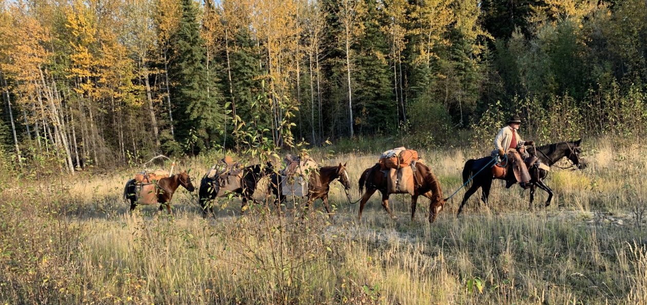
Last Tuesday, our departure day, we got out to my pasture, where the horses were kept, and started sorting and packing our gear. Of course, it took longer than we hoped to get packed up. Separating our food supplies and gear into separate piles, packing them into paniers, saddling the horses, etc, is a real chore. We eventually just started stuffing things into paniers and figured we’d reorganize stuff in camp the first night. We just wanted to get underway.

We finally got saddled and underway about 12:50pm. Three of my grand nieces rode with us the first several miles.

Heading out through Eagar, AZ

The day was clear, not a cloud in the sky, but we faced a direct headwind blowing at about 40 miles per hour, gusting, I’m pretty sure, to over 60. At over 7,000 feet elevation, any wind is a cool one. Our first 11 miles were across a treeless high plateau, just west of Eagar, with that wind blowing in our faces. It was absolutely miserable! I fixed my eye on a cinder pit in the distance, which marked an uphill grade that would eventually take us into the trees and give us some shelter from the wind, and just kept heading for it, one step at a time.

Facing a headwind across this with no shelter in sight

The going was quite slow, as the horses didn’t like the wind any more than we did and we didn’t push them. We averaged about 2.89 miles per hour for the day, according to my GPS.

Late in the afternoon we reached the trees and worked our way along Route 260 to Forest Road (FR) 1325, which we took northward. We looked around and ended up settling on a campsite just off of FR1325, about a quarter mile from Rt 260. There was plenty of lush grass, a small stream of water for the horses, and a nice, level spot for us. We stopped around 6:30pm and settled-in for the night.

First night's camp
First night’s camp

We picketed the horses on the grass and let them get their fill. We let Reno and Jimbo go free and picketed Ranger and Black, since they were the leaders of the bunch. However, when I poked my head up out of my sleeping bag in the morning, all the horses were gone. While Dad started breakfast, I headed out to look for them.

It didn’t take me long to find them. Apparently the grass was just too good for them to leave it, so they just stopped at a fence at the end of the grassy pasture. Not long after, I had them tied back in camp and we were working on getting loaded up. Seemed like we had plenty of time, so we took it, and ended up heading out around 9:30am.

The plan was to head north on FR1325 about 3/4 mile to a point where the road changes direction. We would head off the road and bushwhack about 3/4 of a mile west to get out on top of the plateau, about 400 feet higher. Right off the bat we found an old logging road that took us precisely in the direction we wanted to go, so we followed it about a half mile before it simply petered-out. By our maps, we could see that we were only a few hundred feet short of the top, where it would open up into high meadows on the plateau. We tried several different routes before giving up. We just could not find a way through the trees that a pack horse could negotiate going up that last sidehill.

We turned around and headed back the way we had come and decided to head back out to Rt 260 and follow it on up to the top. That turned out to be a wise decision for us, as it was an easy climb and the road easement is very wide.  At one point we found a tunnel that crossed under the highway for cattle to pass through. It was about 8′ tall and 6′ wide, or so. We took the horses through it and back, thinking it would be good experience for them for when we hit that tunnel at the bottom of the South Kaibab Trail in the Grand Canyon.

Once we made the crest of the hill and started out onto the plateau, we again hit the wind. Just as strong as the day before, but colder. We were now somewhere around 9,500′ elevation. We had to push through the wind again, with no shelter at all, for about another mile, before we found a gate in the fence that allowed us to head back into the trees.

A herd of elk at Fish Creek

We followed a little two-track northward about a half mile and found a valley. The map indicated this was the valley of Fish Creek. As we approached the valley we spied an elk watching us. It eventually headed down over a drop-off into the valley. As we got closer we saw about 10-15 elk reposing and grazing in the valley. It was a beautiful sight.

A spring on Fish Creek

We found our way down a steep decline into the valley, by way of an elk trail, where we located a running spring. We stopped there and let the horses graze a bit while we refilled our drinking water containers. By that time we were tired and Reno was obviously uncomfortable. He was starting to give us trouble, pulling back and having to be dragged along. We decided to find a campsite and call it a day. We located a site just a couple hundred yards away that suited us perfectly: lots of grass, running stream, and a nice, level spot that was somewhat sheltered from the wind.

When we had unloaded all the horses, we found that Reno had a very tender back. He had been carrying a heavy load, over 200 pounds, for two days now, and he was very sore. We decided to make the following day a rest day, despite the fact that we had made only about 20 miles in our first two days, about 3 of which were in the wrong direction.

Finding plenty of firewood at this campsite, we decided to make a campfire for cooking, to conserve our propane. It was pleasant, sitting around the campfire that evening, but we were tired and went to bed directly after eating our supper. We again tied two horses – this time to trees – and let the other two graze freely all night.

Camp on Fish Creek
Camp on Fish Creek

The following morning we slept-in a bit, since we were not going to be moving that day. We got up at around 6:30am. We still had all our horses there in the pasture. Dad untied Black and let him graze, but, out of an abundance of caution, I kept Ranger tied. I’m glad I did, because while we were busy cooking our breakfast, the other three horses headed for home without us noticing. Ranger started snorting and we looked up and only had one horse.

I saddled Ranger and went after the other horses. I was able to follow their tracks well enough to see that they were heading directly down the valley southeastward, following Fish Creek. I found them about a mile and a half down the valley, where the trees began to choke the valley. When they saw me and Ranger, they walked our direction and were easy to catch up. I took Black’s lead and headed back, assuming Jimbo and Reno would follow. They did…for a few hundred yards, but then began falling behind, grazing along the way. Figuring they would continue to follow and eventually get back to camp, I headed on back.

I arrived back at camp, tied Black and Ranger, and ate breakfast, which Dad had prepared in the meantime. When the other two horses hadn’t appeared by the time I finished, I decided I had better go find them. I figured they’d be right about where I last saw them, grazing in the valley. I mounted Ranger and headed out, but they were nowhere to be found. I headed back to camp and Dad saddled up Black and we headed out together to search for our lost pack horses.

Not far from where I last saw them, I located their tracks heading up a cow trail that led back out on top. We followed until we lost the trail, but it was apparent they were heading back towards Eagar. I eventually caught up with them about a half-mile from our last camp. Again, they were glad to see Ranger and came right to me. I caught up Jimbo’s lead and led them back toward camp, with Reno following. He, in fact, did follow this time.

Having learned our lesson, or so we thought, we then tied three horses and let one graze freely, but being the enterprising individuals we are, we devised a method whereby all the horses could get their fill of grazing. We tied rather large rocks to the leads of Jimbo, Ranger, and Black. We tied the horses by their front left foot with a bowline hitch, such that the rock acted as a stake. When we wanted to move the horse to better graze, we simply moved the rock. We were pretty pleased with ourselves, until the next morning, when I poked my head out of my sleeping bag and found that we were horseless. All four had left the valley.

After looking around, it became apparent that something, elk or maybe a coyote or lion, had spooked them during the night and they had dragged their rocks until they had come off the leads and the horses ran freely with their 35′ foot leads attached.

This time, while Dad made breakfast, I headed out on foot to locate our wayward herd. I was pretty sure I knew where they had gone, so I headed out. I again located their tracks on that same trail as before, heading up onto the plateau and off toward Eagar. This time they didn’t make it quite as far as before, and I might have walked right by them, except that Ranger nickered at me when he saw me. There they were, standing back in the trees, looking like they were waiting for me to find them.

They let me approach and I started catching up leads and tying them to trees, while I untied the foot-ropes. Ranger had a knot and scrape on his nose, but other than that all the horses were unharmed.  As far as I knew, none of the horses had ever been ridden bareback. I would have trusted Ranger, but at 16 hands, there was no way I was going to be able to get on his back. So, I led them all back to camp on foot. When I got back, my GPS indicated I had walked about 3 miles, not counting the distance I walked earlier without the GPS. I figure I walked about 5 miles that morning. I was pooped!

So, there it was Friday morning and we had made a total of about 17 miles, and a bit.

Reno’s back was nearly back to normal now, as we had been giving him a helping of bute each morning to ease his pain and reduce the swelling. He was still a little tender, but wasn’t flinching when I brushed his back. We realized that our packs were overloaded, due to the fact that we had brought 100 pounds of Equidyne pelletized alfalfa feed with us to supplement the horses’ feed. We made the decision to dump the feed, since there was plenty of grass available. This brought our loads back down to far better levels and allowed us to redistribute the weight among the two pack horses more evenly. In an effort to take it easy on Reno, we decided to put the heavier load, the hard-sided paniers and top pack, on Jimbo and let Reno carry the soft paniers.

Back on the trail, leaving Fish Creek

We got packed up and were back on the trail by about 1pm, heading west along Fish Creek, toward FR 117.

What a beautiful ride it was. We met FR 117 less than an hour later and headed northward. We joined FR 61 several miles up the road, near the base of Green’s Peak. We followed it about 7 miles west and north toward FR 96, but stopped about 3/4 of a mile short of it, making about 11 miles for the day. We had decided to keep our mileage around ten miles to take it easy on the horses and to avoid soring Reno’s back again.

What a ride!
What a ride!

This day’s ride was the kind of ride Dad and I had dreamed about. We had horses that got along well, so we could ride side-by-side, which we did almost all day. We talked, dreamed, schemed, spoke of the ranches we wished we had, and talked of horses and dogs we had known over the years. I loved hearing Dad’s stories of his youth, growing up in Panguitch, Utah and surrounding areas. As badly as the day started, this day became one of those perfect days for us.

IMG_2293
Look closely in the middle and you’ll see the antelope fawn

Several miles up FR 61, we came upon several Pronghorn Antelope. One of them had a fawn that could not have been more than a day old. Dad had seen the fawn, but I hadn’t. Suddenly it jumped up and ran across the road in front of me. I was able to snap a quick photo of it. It was something one does not often see.

We had hoped to reach FR 96 before stopping for the night, but as we passed through Gillespie Flat, we saw a beautiful campsite, several hundred yards off the road, back in some Ponderosa pines, at 8,653′ elevation, with a spring and good grass a short distance away. It was too nice to pass up.

Elk checking us out
Elk checking us out

As we were unpacking the horses, we heard something snort from back in the trees. We eventually spied a cow elk watching us from about two hundred yards away. None of our horses took note at all, except Jimbo, our mustang. He located that elk the first time it blew and was watching her with piqued interest. The elk would snort at us and Jimbo would snort right back. This went on for several minutes, with the elk working its way closer all the time. Eventually, the elk approached to within about 30 yards of camp, inspecting us and our horses closely, before moving off.

Camp Day four, on Gillespie Flat

We again decided to make a campfire for cooking and it was a good decision, because it got very cold that night, down into the 20s. We let the horses graze freely for the early evening, but made sure we kept a good eye on them. After eating our supper, we tied all four horses, Ranger and Reno by foot-ropes, so they could graze freely on the good grass. It was their turn.  After supper, Dad and I sat around the fire and enjoyed the evening. We hit the sack around 9pm.

About 2:00am I was awakened by the sound of pounding hooves. I jumped up out of my sleeping bag, grabbed my flashlight and shined it toward the sound. I saw Ranger tied up against a tree and struggling. I ran to him and found he had wrapped his foot rope, around the tree until he was snubbed against the tree with his right side against the tree and his left front crossed in front of him and twisted around the tree trunk tight against the rope. He was pulling back against it with all his strength. I tried to calm him, but he was in a panic and there was no way for me to help him but to cut the rope. I ran to my bed to grab my knife, and about halfway there I heard a loud “snap”, like a large tree branch breaking, and I knew I was too late. I grabbed my knife and was back at his side within seconds. I slashed the rope with one pass, releasing his leg, but I could see his left front leg was broken, up high near the elbow. It hung awkwardly and useless, as he stood three-legged.

Ranger didn’t struggle, didn’t try to walk. He just stood there looking at me as if I might be able to help him. I held his neck and talked to him as I sobbed, knowing there was nothing I could do; knowing I would have to put him down.

By this time, Dad had made it to us. He held Ranger while I went to my saddle and retrieved my .22 rifle. I loaded it with several rounds of ammunition and carried it back to where Ranger was standing with his head held low. I spoke a few comforting words to him, mostly of comfort to me I suppose, but maybe it helped him too. I rubbed his face, said my goodbyes, then I placed the end of the barrel on his forehead and squeezed the trigger. Ranger went down immediately, shuddered a little, then relaxed. It was all I could do to contain myself.

After putting Ranger down, Dad and I went back and slid into our sleeping bags. We both shed tears as we tried to console ourselves, me for my horse, Dad for me. Surprisingly, I fell back asleep.

About 3:30am I was suddenly wide awake, with the words ringing in my brain, “Go re-tie Reno!” I had forgotten all about him being foot-tied as well. During the incident with Ranger, he had been twenty feet from his tree, grazing calmly. I jumped out of bed immediately, grabbed my flashlight and ran to Reno. I found him with about one more turn around the tree left in the lead rope before he would have been in the same predicament as Ranger. I tied him by his halter rope, then untied the foot-rope and went back to bed, passing the lifeless body of my dear friend, Ranger.

This has been difficult for me to type. The image of Ranger struggling against the rope and the sound of his leg breaking are fresh in my mind. The knowledge that just ten seconds more would have turned that tragic incident into a simple learning experience fills my heart and mind with ”what-ifs”. Knowing that if I had tied him by his halter rope, rather than a foot-rope, fills me with regret and sorrow. I just didn’t know.

The following morning, we contacted some friends, who drove out and helped us load up our horses and gear and return to Eagar.

I left Ranger there at our camp, feeling like there was no better resting place than right where he lay.  I, myself, have often thought I would prefer meeting my end leaning up against a tree overlooking a beautiful valley high in the mountains, to being buried in a cemetery. His body will eventually return to the earth, providing nourishment for plants and animals alike. I like that thought. Nothing wasted.

I clipped a few locks from Ranger’s beautiful tail. I plan to make a hat band from them, which I will keep in his memory, so that part of him is always with me as I ride my trails.

I hope I am not judged too harshly for what happened to Ranger. He had been foot-tied many, many times in the past and never worried me in the least. I never considered that such a thing could happen. I had no idea. I have learned. It was a hard lesson, one that will not be forgotten.

See you on the other side, Ranger. I miss you already.

My last ride on Ranger

Days 20-23…From the Gila Box to the Blue Range Primitive Area…Second Edition

This post will cover Days 20-23 of our pack trip last year.

Day 19 left us camped out on a hilltop overlooking the Phelps-Dodge mine at Morenci, Arizona, just north of the northeast end of the Gila Box Conservation Area. We were only about a mile or so west of US 191, just south of Clifton. Our route this day would take us east for several miles, then northward toward the southern part of the Blue Range Primitive area. This day would see the last of the harsh terrain and conditions of the low Arizona desert and start putting us into the higher, greener elevations.

On Day 20, April 30, 2015, we arose early, as always, fed the horses, rolled up our beds, had breakfast, and hit the trail again. We hit US 191 before 10:00am. Our first challenge of the day. The State of Arizona, or maybe the Bureau of Land Management, made this very nice gate there at the cattle guard at the approach to the crossing. Problem was, the gate would not open. The bottom foot or so was buried in sand. Took me about a half hour to dig it out, so we could open it far enough to get the horses through.

Lunchtime and a rest

After that, we crossed the highway and rode the shoulder for about a quarter mile north to join Table Top Road, which took us north, then turned southeast for several miles to a small township, of which I cannot recall the name. It was more like a housing development than a town. As we entered the town, we found a small grassy spot near a diversion dam, where we let the horses graze for an hour while we had lunch and rested in the shade of a tree. It was a good stop for us, because little did we know what was waiting for us.

After passing through another small township, on Ward Canyon Road, we turned northeast on Skyline View Road, then took a right on Rattlesnake Road. Rattlesnake Road was a dirt road that headed northeast toward the mountains. The terrain we had been passing through up to this point was regular old Arizona desert. Very little vegetation, other than greasewood and the occasional mesquite tree. The rocky ground was not quite as bad as what he passed through the previous two days, but it was still rough. It was nice to have a dirt road going in the direction we needed. After several more miles we came to the end of the road. Well, at least the maintained road. We found ourselves coming to a USFS road that obviously hadn’t been maintained in a while. We could see it stretching before us, climbing straight up a narrow, very steep canyon. Rattlesnake Canyon.

From the top of Rattlesnake Canyon

Luckily, there was a good waterhole at the foot of the road, where we watered the horses. We were joined there by a herd of horses. I doubt they were mustangs, but they were pretty wild. The road was extremely rocky, but at least it wasn’t all volcanic rock. The canyon was scenic, but the climb was so steep we didn’t get to look around a lot. I recorded a short clip or two on my iphone, but the battery started to go, so about half way up the canyon I got my GoPro out and tried to get a couple more clips.

We climbed 1200 feet in under a mile. We had to stop a number of times to rest the horses. By the time we crested the saddle at the top of the canyon, we were resting the horses every 100 yards or so. We got a good laugh as we came to the last hairpin turn before the crest. There was a “dangerous curve” sign just after the turn, on the high side. Yep. Big as life, a real live Arizona road sign. I can tell you that even a rock climbing Jeep, or a 4-wheeler, for that matter, would think twice before tackling that road! Lucky for us, our horse feed was running low, so our horses were packed lightly.

This day I rode Ranger and Dad rode Jimbo. Daisy was again developing saddle sores on her withers and Lizzy had a sore back. Lizzy had started developing a lump on her back, about where my saddle cantle rode, on Wednesday. I suspected there were two factors involved: my having to carry Clancy in the saddle for much of the day on Wednesday and the fact that she had started to drop a little weight, which made her already prominent spine (Fox Trotters are built that way) even more prominent, which caused the saddle to put pressure there.  I had given her a helping of bute with her morning feeding and she was packed very lightly. The pack saddle allowed her to move with no pressure on her sore spot. I hoped that would help.

Clancy was making work of things. His paws were very sore and his strength wasn’t recovering with a night’s rest as he had early in the trip. He was simply wearing down. On this day I carried him most of the day on my saddle on Ranger.

The pond at the top of Rattlesnake

We took a short break at the top, looked around, rested the horses, then headed on down the road. The descent on the other side was not steep, but quite gradual. It was also treed with oak, juniper, and cedar. There was grass and other vegetation. It was a completely different world that the other side of the hill. After a short distance we came to a small pond with an old line cabin. We watered the horses there, but didn’t stop long. We had to make several more miles before we could stop for camp.

I don’t know whose ranch land we were passing through (I’m sure it was BLM range), but I can tell you they had some good cowboys. This land was very well maintained, with well-maintained stock ponds every mile or so. We saw evidence at every turn of hard work having been put into keeping up that range over many years. What a beautiful ranch it was.

Just before sunset we came upon a stock pond with a very nice corral. There were nice trees and a perfect level spot for camp. Problem was that there was this huge black angus bull occupying the campsite. Eventually we were able to crowd him off our selected spot, but he stayed close by all night. Seemed like he liked the company. We watered the horses, then released them into the corral. They enjoyed the freedom of not being tied and all had a good roll. We enjoyed our camp that evening, although we were beat, having made 16.4 miles.

After a short night, we were up again at sunrise. We were packed and moving by 9:00 am. Our goal for the day was to pass the Martinez Ranch, on the San Francisco River, about a couple miles from the confluence with the Blue River, start up the Blue, then camp at a stock tank on Pat Mesa. After that, we would head north on the Blue, entering the Blue Wilderness Area. We had a stopover planned at a friend’s place at Blue, Arizona, which we believed we would reach by Sunday. Turned out that was very optimistic. We hoped to be able to have someone meet us there to take Clancy back to Eagar with them. He was having a hard time of it.

We enjoyed Day 21. As I said, we passed through some very nice ranch land. We passed through rolling hills for most of the day, and the weather was pleasant. We passed the Martinez Ranch just before lunchtime. It didn’t look like there was anybody around, so we kept going. We rode down to the San Francisco River, watered the horses, then let them graze for an hour. We had our lunch there and refilled our canteens. That was about the 250-mile mark on our journey.

From there we followed the river west for about two miles, to the confluence of the Blue River. These were tough miles, during which we crossed the river six times. One crossing was deep enough to come up over my boot tops, but not deep enough to flood our pack paniers. The trail along the river had not been maintained, so it was difficult to follow, however we were again blessed.  A four-wheeler had passed through not many days before us (judging by the tracks) and the rider had marked the trail with ribbons. Without that, we would have had a very difficult time finding our way those two miles.

At the confluence of the Blue, we turned north to follow it. The Blue River bed was much wider and more spread-out than the San Francisco. It was quite beautiful and was much easier traveling.  We followed the river for a quarter mile or so, but saw that it was coming from a very narrow canyon. The map showed that if we entered that canyon we’d be stuck in it for several miles before it spread out. Not knowing what we might find in there and being concerned about quick sand and the thick willows growing along the banks, and just having bushwhacked along the San Francisco for two miles, we elected to seek a route up out of the canyon and to keep to the mesa until we reached Juan Miller Road the next day.

Our 1967 USGS map showed a trail that ascended up out of the canyon where we were, but our current topo map did not show it. We searched around a bit, expecting that the trail was not maintained anymore. We finally came upon it and found the USFS or BLM had plowed it up and put up berms to keep it from being used. Lucky for us they did, or we would never have been able to follow the trail! Had they just left it alone, it would have grown over and disappeared, but their efforts to close the trail by placing a berm in it every twenty yards or so, guided us up the steep trail until we reached the top at Pat Mesa. By this time, Dad and I were bushed, as were the horses. The last three or four miles had been tough ones.  We began looking for a camp, still about three or four miles short of our goal.

We saw a stock tank on the map, which gave us hope, but when we reached it, it was dry. We continued on, thinking we would be making a dry camp. We finally came upon a suitable place, with a small clearing among cedar and juniper trees, but as we were about to dismount, I noticed across a canyon that a two-track road turned up into the mouth of a canyon. At the mouth of the canyon I could see some sort of structure. I told Dad I thought it might indicate a water source, as I could think of no other reason for a road and a structure out in this area. It was only about two more miles to round the head of the canyon and cross over, so we continued.

Lucky we did, because we came upon an improved and running spring, with a cowboy camp and a corral. Apparently it was a working camp, but every body had headed to town for the weekend (it was Friday evening). We imposed ourselves on their hospitality and set up camp, tossing our sleeping bags in their tent. It was nice and we slept well. We left them a “thank you” note and let them know we left the camp like we found it. Ruth Brockman, of the Turkey Creek Ranch, sent me an email later, saying she had received my note and were glad we had made ourselves comfortable. She invited us back for a visit whenever we get back down that way. I’d like to do that sometime.  We made 16 miles that Day.

Saturday, May 2, Day 22, was more of the same, traveling across Pat Mesa, following a “cat track” that was used as a ranch road. Again, we saw much evidence of hard work being put it to maintain the range and keep it in good condition, which it was. The road was fairly easy until we got a couple miles short of Juan Miller Road, at which point it became very hilly and rocky. It became a lot of work on the horses. That’s one problem with following a “cat track”. They are named that, because they are bulldozed out of the mountains. Bulldozers are nicknamed Cats, after the company Caterpillar. Cats don’t necessarily take the easy route and don’t make many switchbacks. When they do, you know it’s a steep hillside.

We had just descended down into Pigeon Creek and were looking at two options: we could turn east about a quarter mile and strike the Blue River, following it upstream for less than two miles to Juan Miller Road, or we could stick with the cat track for another 4 miles to get there. We were still leery of following the river, so we decided to go with the known-quantity and continue on the cat track. We climbed the very steep ascent out of Pigeon Creek and were just cresting out when we came upon a hiker. We stopped and talked to him for a few minutes. It took me about two minutes to recognize him as a man with whom I had communicated online about two years before regarding possible routes for us through these mountains. What are the chances?

Brett Tucker is a long-distance hiker, who knows southeastern Arizona like the back of his hand. He has the website “Grand Enchantment Trail“, which documents a long-distance trail he designed through several mountain ranges in southeastern Arizona. He just happened to be out scouting a new route for a trail. Much of the route I selected for our trip was based on his advice. Once I realized who he was (he recognized me at about the same time) we asked his advice for our route to Juan Miller Road. He suggested that we turn around and head down Pigeon Creek to the Blue and follow it. He assured us it was a safe, easy, and scenic passage for horses. We followed along with him until we reached the Blue, at which point we said our goodbyes and he turned south while we went north.

Incidentally, after we finished the trip, Brett sent me an email. He said he returned to Juan Miller road via the cat track. When he reached the road he found the gate locked. Our passage would have been blocked. What a disappointment that would have been for us.  Another of those simple little “tender mercies” of the Lord to help us along on our trip.

And thus began the most pleasant part of our trip, traveling up the Blue River to Blue, then up Red Hills Road and over the top to Eagar.

We headed up the Blue then, crossing back and forth across the crystal clear water about ankle deep most of the time. Cottonwood trees grow along the banks and willows are thick in many places, but we were always able to find a decent way through. In some places the cliff walls became very tall, imposing, and beautiful. There were places where the river passed through narrow cracks in the cliff walls, and we passed through in the river. Travel wasn’t easy, but it was pleasant. We made the short couple miles to Juan Miller Road, then headed west until we found a two-track designated 4-wheel-drive road that headed north. That road took us to the historic Fritz Ranch, now a USFS property. We took Blue Trail #101, which heads there at Fritz Ranch. The trail follows the Blue River all the way to Blue Road, and that was our plan. We planned to make camp about 6 miles or so up the trail at the HU-Bar Ranch, which is an old abandoned ranch house, used by many passers-by as a camp stop.

This day I was riding Daisy. I had both Ranger and Lizzy under pack. Turned out that Ranger showed a sore back the night before. Had to be from carrying Clancy in the saddle. Not only that, but holding Clancy in my lap caused me to sit back farther in the saddle and caused me some back strain. I was developing a very painful knot in my upper back.

The days on the trail, through very difficult country, had taken its toll on us. Dad and I had found ourselves becoming increasingly short-tempered with ourselves, with each other, and with our horses. We were tired, the horses were tired, Clancy was tired…we were just beat. It was Saturday afternoon and we were looking forward to a much-needed Sunday rest.

No more than about 1/2 mile up Blue Trail #101, one of the horses started acting up a little and I was getting angry at him. My anger was spreading through the whole bunch of us pretty quickly. Suddenly, I looked around us and saw that we were in a pretty decent place for a camp. I turned to Dad and said, “We’re camping right here tonight!” We were about five or six miles short of our goal for the day, but we were done. We made camp right there. We made 17.2 miles that day, 273 total miles on the trip.

We didn’t spend a lot of time with things that afternoon. We simply cared for the horses and staked them out on the plentiful grass, then went to work setting up our camp. We had a couple hours before sunset, so we just rested and relaxed while the horses grazed. Turned out this was a good decision and we were camped in a pleasant spot.

On Sunday morning we stayed in bed a little longer than usual. The weather was pleasant, the morning cool, and we were comfortable. After we arose, we fed the horses a bit and moved them to new areas to graze. We found that Black was a bit lame. Both his rear fetlocks were quite swollen. We gave him some bute with the feed and hoped that rest and some prayers would have him ready to go again the following day.

Lizzy and Ranger seemed to be doing better. Their backs were much better. Daisy’s saddle sores were getting worse, though. Nothing we could do about it. We had taken it as easy on Daisy as we could, to the detriment of the other horses. All we could do was to keep salve on them to keep them soft and lubricated. Clancy was doing a little better, after having been hauled in my saddle for much of the previous day. Dad and I were losing weight quite rapidly. The miles were showing on all of us, except Jimbo the mustang and Honey the mule. They seemed impervious to all the travel and work. They looked just about like they did when we started the trip 23 days before. Not a mark on them.

We had learned by now that our herd of horses…and one silly mule…would follow Ranger about wherever he went, but that Lizzy was the Queen Bee of the herd. Ranger would generally stay where she was and the rest would hang around Ranger. We had also learned that Lizzy tended not to stay in one place very long. She would graze for a couple minutes in one place, then walk off 20-30 feet and start again, which kept our whole herd moving constantly. We found that if we staked Lizzy the rest of the horses would settle down and graze lazily in the same general area. So, that’s what we did for Sunday. I tied Lizzy and moved her to a new spot every couple hours and the rest of the herd stayed around in the general area, calm and relaxed.

I went down to the river to wash clothes and take a bath. It was…refreshing, to say the least! While I was down at the river, I suddenly heard a whinney from way down the canyon, maybe a quarter mile, then an answer from Lizzy, tied there at the edge of camp. Suddenly there was the drum of hooves at full gallop rushing toward camp. I got to where I could see, just in time to watch our entire herd run full speed through camp! Luckily, they stayed mostly to the trail and didn’t actually run over our camp. They stopped immediately after passing through camp, turned around and came back to see Lizzy. Then they all settled down to grazing calmly again.

Dad and I passed a particularly lazy and restful day. The horses and Clancy did the same. We were all healing and resting our tired bodies and minds. The horses seemed to particularly enjoy the day off. A fresh bath put me in a very restful and relaxed mood. We all felt pretty good. It was a good day.

That night, Dad and I were sound asleep, sleeping very well indeed, when I was awakened by a whinney way off in the distance, then an answer from Lizzy, tied right there at the edge of camp…OH NO!!!!!

Stay tuned for the last five days of our wonderful horse packing adventure in my next post.

P.S.

I have discovered a work-around to fix my upside-down photos on the posts. Eventually I’ll go back and repair the older posts. Thanks for your patience.


Days 10-15, Crossing the Desert to Safford

On Day 9, Sunday April 19, Dad and I had spent the day in camp at the mouth of Whitetail Canyon. Feeling refreshed, both in body and spirit, and the horses and Clancy being well rested from a day of rest, we were ready for the trip across the desert to Safford, Arizona.  Joshua Jensen and Al Smith, our capable guides through the Chiricahuas, had left us with a new supply of 200 pounds of Equidyne pelletized alfalfa for the passage across the desert. The saddle sores that had been starting to show on Daisy’s back were healing up after four days of being ponied bareback. We were in good shape. Our only concern now was being able to find water. We had about 80 miles across some very flat, dry desert country before we reached our next destination, Joshua’s place in Safford.

We had a good morning and it looked like for the first time we would be able to make an early start. Just as we were getting ready to mount, a fellow wanders into camp and we get to chatting. It was interesting conversation. The fellow was a local conservationist and birdwatcher. I neglected to take down his name and have forgotten it. It was he who had made the rock cairns we tried to follow on Saturday. Anyway, we talked too long and didn’t make it out of camp again until about 9:30am.

I was riding Lizzy, and, as usual, she set a pretty good pace for us. We left the mountains and joined Nolan Road and headed north, keeping just off the road to avoid vehicular traffic. Our goal was to reach San Simon, where we would cross under I-10 and find a place to make camp.

Somewhere along the route between Whitetail Canyon and San Simon on Nolan Road, we passed the 100-mile mark of our trip.

About half way to San Simon we found a water hole where we took a break and let the horses graze on some nice grass we found there, while Dad and I ate our lunch. For the entire trip our lunches consisted of a few bites of beef jerky, a Cliff Bar, raisins, and a bit of trail mix. We seldom stopped for lunch, usually eating a little at a time as we rode. As small as our lunches were, it was sufficient and we fared well. We were definitely hungry by the time we made camp in the evenings, though.

Dinner and Supper!
Dinner and Supper!

Our breakfasts and suppers consisted of dehydrated meals, made from ingredients mixed and matched from a food storage kit we bought from Walmart for the purpose. We had a variety of vegetable soup, creamed potato soup, corn chowder, and various combinations of those. Breakfasts included dehydrated eggs, the occasional packet of oatmeal, potato shreds, and some bacon bits. We cooked everything over a single coleman burner on a small propane can. Quite frankly, I don’t remember well what we ate most of the time. I’m sorry to say that some of the food wasn’t all that appetizing. Dad and I lost quite a bit of weight on the trip. I think the thing we missed most, in our suppers and breakfasts, was the fact that the dehydrated food kit included absolutely no meat! The imitation meat was also imitation tasty.

By nightfall, after 22.6 miles on the day, we made San Simon. We stopped by a ranch house, and finding nobody home, we helped ourselves to a spigot to water our horses and fill our canteens. We met a good friend of the rancher the following day, who happened to stop by for some friendly conversation, so we passed on our thanks for the use of the water spigot.

Finding no good place for a camp, we pulled off into a thicket that offered some concealment from the locals and made a dry camp. It was dusty, dirty, and full of thorny brush. We hit the hay early and departed early as well. Josh and Al stopped by in the morning on their way through town and helped us get loaded up and started. We then went back to the ranch where we watered the evening before and watered our stock. On our way back into town we ran into the fellow I mentioned above, Ron Mahan, who was able to give us some good directions for getting us into a wash, the San Pedro River, and under I-10 without having to concern ourselves with road traffic.

A nice pond in the desert

On this day we headed up the San Pedro River bed (otherwise known as a dry wash), which ran generally in our direction. We stuck to that for several miles, but knew we needed to find water for the horses. We struck a road heading east-west that Mr. Mahan had told us about. We followed it west about a mile and found two or three houses and a very nice pond. The pond had bass and panfish in good numbers. I suspect the locals had stocked the pond for their own fishing and eating pleasure. Strangely enough, our horses weren’t very thirsty. We left there and got back into our wash and continued northward.

As we were passing through a part of the wash that was thick with brush, I heard a muffled grunting and looked around to see what it was, knowing the area was prime for Javelina. I spotted a little pig no larger than a small puppy rooting and playing in the grass. We tried to get a picture of it, but the darn thing was so well camouflaged that when we saw the pictures we couldn’t find the little Javelina in it! The mother was nearby, so we let them be. An angry javelina is nothing to mess with. We moved on.

Shortly thereafter the wash became rather problematic to follow. It became deep, to where we could no locate ourselves with regard to the mountains and we could not see to find the next waterhole we were aiming for. It was also so choked with mesquite that it was tough, and painful, to get through in places. We climbed up out of the wash and began to head overland on higher ground.  Once on top, we spotted in the distance what looked like a cottonwood tree, which often indicates a well or water hole, so we headed that way.  It was, in fact, a cattle watering tank, but it hadn’t been maintained in a few years. It was choked with algae and moss. The horses drank from it, but not deeply. They didn’t like it.

Camp at Butte Well
Camp at Butte Well

By nightfall, we had again traveled about 18 miles. We camped that night at Butte Well, located just about a half-mile east of Orange Butte. There was a decent water trough for the horses, but nothing for us. Again, the water was full of green algae. At this camp we had to watch for cactus, because there was a low-growing species of prickly pear that you really had to watch out for. This area was very dry, with few trees even tall enough to tie the horses to. Again, not a very hospitable camp. This day, Clancy’s feet got pretty sore and I ended up with him on my saddle for several miles. The mileage we were making was getting to him. I ended up with him on my saddle quite a bit over the following few days. That night I checked his paws and found a mesquite thorn about 3/8″ long stuck all the way up in one pad.

The following morning I attempted to filter some of the water from the trough, with my Katadyn gravity-feed water filter, to fill our canteens. Lesson learned: Don’t try to filter filthy water! The algae plugged my filter before I had gotten a quart of drinkable water. That was a problem, since we didn’t have a spare filter. That meant we had no means of replenishing our drinking water until we reached Safford, another 40 or so miles farther along the trail. Well, we could have boiled water in a pinch, but that takes propane and time.

No, he's not dead.
No, he’s not dead.

We got back on the trail the following morning and followed a two-track ranch road westward. About five miles farther along we came to a solar-powered well with running water. We were able to fill our canteens, but the water tasted salty. The horses were fine with it, though. We ended up doing a lot of cross-country bushwhacking that day. It was a long one.  Around lunch time we located another waterhole that was apparently privately owned. There were a few improvements around it, such as a pathway and a small picnic area. We watered there then went a mile or so farther on, where we found some good grass. We let the horses graze for about an hour, while Dad and I ate lunch and rested.

We crossed the San Simon Fan area that day, which is a stretch where the government build low spreader dams to spread out the rain runoff to control erosion and spread the water over a wider area to benefit the local ecology. What it did, however, was to spread very fine silt over a very large area. Here’s a video that shows the area. It took us several hours to cross it. Here’s a video.

We made camp at Bailey Well that night, after having made a total of 21.2 miles. We had hoped to make Tanque, but would have arrived long after dark and we were completely bushed. We were tired!

Bailey Well was another solar-powered well, but we arrived after the sun was setting behind Mount Graham, so we obtained no water for our canteens. Horses were watered well, though. We ran out of drinking water the following morning, having just enough to make a breakfast.

The next day, Day 14, Friday , April 24, we headed north on a dirt road. Safford was about 20 miles away, so we hoped to make it all the way. We made Tanque around noon. We were lucky enough to find it a running well, so we were able to fill our canteens. The water tasted a bit better than the water we got from the previous well.

We followed dirt roads the rest of the way to Josh’s place, which was lucky for us, because it got us through the numerous cholla forests in the area. The cholla was flowering, so it was quite beautiful, but cholla is a true hazard for one traveling by horse. It is also commonly called “jumping cactus” because it grows in clumps, little balls of spines, that break off and stick when one brushes up against them. The plants propagate in this way, so the cactus grows in patches, or forests, as the case may be. We passed by several “cholla forests”.

Josh's place
Josh’s place

We made Josh’s place late that afternoon, after a day of 20.8 miles. It was good to release the horses into a corral and feed them hay. Josh and his family were not home for the weekend, but left us the use of the house. He also left us the use of his pickup, so we headed into town immediately after tending the horses, to look for a water filter for my Katadyne filter. No such luck, so I contacted Outfitter’s Supply in Columbia Falls, Montana, from whom I purchased the filter, and they overnight expressed two filters to me.

That evening, Josh’s neighbors, the Bodines, brought us a home-cooked meal of wild turkey. Their 14 year-old boy, Evan, had killed the turkey during the spring hunt. Jessica Bodine cooked it up with dumplings. It was heavenly!

The best part of the evening, though, were the showers at the end of the day! In order to not abuse the hospitality shown by Josh and his wife, Dad and I made our beds in the garage. We really didn’t want to get their house filthy. We availed ourselves, however, of their washer and dryer. It was wonderful to feel clean and have clean clothing again.

Dad on our mustang, Jimbo

On Saturday morning, the Bodines brought us a very tasty breakfast, Al came to put shoes on our mule, Honey. After he arrived, we headed for town to buy shoes and some other supplies. While we were driving around town, Al took us for a drive to sort of scout out a route past Safford. We located a power line that offered a decent route. While we were scouting, another of those little helps from heaven happened. We met Clay Gomez, who owns a ranch through which that power line runs. He owns the only gate in the fence for many miles. He was very cordial and gave us permission to pass through his gate. When we arrived there later that evening, he had left the gate unlocked for us.

Me on Lizzy, with our string
Me on Ranger, with our string

By the time we arrived in Safford, we had traveled about 170 miles.  Our mule, Honey, had been barefoot all that way. She started getting tender on Wednesday, so we had Al put shoes on her. We also re-stocked with the last of the Equidyne feed we had stashed with Josh before we started the trip. Our Katadyne filters arrived via UPS by 9:30am. Amazing! We got ourselves packed up and hit the road about 11:30am.  We followed the power line route, as planned, and made good time. We passed through several fences, but none was locked. We ended up making it about 19.8 miles that afternoon and made camp on the Gila River, just north of a small town named San Jose.

The following day was Sunday, our rest day. We had a nice camp, with water, grass, a place to tie our horses, and a nice spot for our bedding. It was a good day to pass the Sabbath. We needed it, as the mileage we made over the past few days was starting to show on the horses. They needed a rest. So did Clancy. So did we.

Stay tuned for days 16 and 17 later this week, and some trail stories you are sure to enjoy.


Day Six

Day six, for Dad and me, was both tough and wonderful. We had made our first fifty miles and all was well. Now we had entered the first range of mountains along our route: the Chiricahuas. We were excited to get off the dirt roads and onto some mountain trails.

Joshua Jensen and Al Smith had arrived the previous evening. Joshua had fixed us a meal of T-bone steak, cheese-covered potatoes, fetachini, and brownies, all made even better by sitting around a campfire in the mountains, enjoying the company of good friends. After a week on the trail, eating dehydrated meals with no spices but salt and pepper, that dinner was heavenly!

On this morning, we discussed and planned out our route before getting packed up. The original route I had planned had been exposed to a devastating fire several years before and was impassable and in places nonexistent. Good thing Joshua volunteered to join up with us. Joshua and Al, being intimately familiar with the Chiricahua trail system, mapped out a route for us that was both beautiful and exhilarating…and pretty tough in places. Whatever else the route might have been, it was unforgettable.

Al in front, Joshua following

The route we ended up taking through the mountains took us up the Monte Vista Trail out of the North Fork of Rucker Canyon, where we were camped, to hit the Crest Trail just on the north side of Monte Vista Peak, following it over Fly Peak (where we camped that night) and down to join USFS 42C at Rustler Park. We followed 42D to Pinery Canyon Road, where we turned west (my journal says east, but it was west) and followed it down to the North Fork of Pinery Creek . We then followed North Fork for a ways, then turned north on a trail to Hands Pass. From there our route took us past Barrel Spring and through Bloomberg Canyon (where we camped the following night) and into Whitetail Canyon. We attempted to turn west up Indian Creek Canyon from there, but gave up after about three miles, finding the trail impassable (non-existent) for horses. We ended up returning to Bloomberg Canyon, staying our Sunday rest day there, then left the Chiricahuas through Whitetail Canyon Road. We then hit Noland Road and followed alongside it north to San Simon.

Now that you have our route through the Chiricahua mountains in mind, let me tell you about our companions and their mighty steeds. Both Joshua and Al ride mules. I have always had an interest in mules, but this was my first extensive experience with them on mountain trails.

Joshua is a tall, young US Border Patrol Officer in his late twenties or early thirties. He rides for their mounted patrol out of the Safford District. He’s a nice, clean-cut man and a pleasure to be around. A fine horseman and experienced packer, he has converted over to mules. He has two of them. Treasure is an experienced molly out of a thoroughbred mare. She stood about 17 hands, was almost totally black, except for a few highlights around her flanks and legs, had very fine legs and excellent conformation. She was also a bit ornery. Riding behind her, I had to watch that my horse didn’t get too close. His other mule, Tigger, was shorter and younger, about 4 years old as I recall, about 15 hands or so, dun-dish or roan-ish in color, with zebra-striped legs. A very pretty molly, she was also slow as Christmas. She just didn’t care to keep up with the rest of us. Joshua had recently acquired her and was still working with her training. While his taller, older molly had a very nice walk and could really eat up distance, the slower one held her back.

Al, on the other hand, rode a dark molly, about 15-1/2 hands or a little better, that was a real handful. She was very skittish around anyone but Al. She could really walk out, though. I mean, even my Fox Trotters had a hard time keeping up with her. Now you have to see this in your mind’s eye as I describe Al and his mule. Al stands all of about 5′-5 or 6″, and weighs in at around a buck-40 or so. He has a full beard, almost as full and nice as Santa Claus’ beard, but a little more gray than white. He has a grin that just makes you want to smile all the time and a quick whit that always kept us wondering what he was going to say next. He is retired out of the Arizona State Prison system (employee – not inmate!).  He now spends most of his time riding his mule. When Al was up on top of that mule, the two became one. Now, as I say that, you must understand my meaning. Al and his mule operated as a single unit, but, quite truthfully, Dad and I never quite knew who was in charge, the mule or Al. After much consideration, we came to the conclusion that it was simply a cooperative system – sometimes Al was in charge and sometimes the mule was in charge. Whatever it was, it was an amazing thing to behold.

What an experience it was traveling with these two men and their mules. As you will see, Joshua and Al were, together and individually, another of those gifts from Heaven that happened to us so often on this trip.

After a good breakfast, we were loaded up and heading up the trail by 9:15am. As Daisy, the Quarter Horse had started showing signs of saddle sores on her withers, we decided to cut our gear and leave one pack saddle in Joshua’s trailer and pony Daisy bareback for a few days to let her heal up. We would retrieve the gear and a few more bags of feed when we exited the mountains at Joshua and Al’s end point.

We started up Monte Vista Trail. It started out as a pretty easy trail, but soon entered a series of switchbacks and a steady climb. We ascended more than 3,000 feet in a matter of about four-and-a-half miles. Most of the trail was well maintained, but there were several deadfalls we had to go around.

Ascending Monte Vista Peak looking south

As we climbed higher, the views began to open up a bit, allowing us to catch sight of where we had been the previous days. It was quite the sense of achievement I felt, looking back over the hills, seeing in the far distance the areas we had come through. It was a strange sense I felt, which eventually became a familiar and welcome feeling. It was the emotion connected with the thought that I had been over there – not just that I had been there at one time or another, but that I had just come from over there on my horse, with my dad. It was a special feeling that is hard to describe, and it was entirely new to me as I looked out over those mountains, hills, and deserts.

Nearing the top of the shale slide

As we neared the summit of Monte Vista Peak, we crossed and ascended a looooong sidehill that dropped off about half-a-mile below us. This mountainside was pure shale and very little vegetation grew on it. The shale was ankle deep when you stepped off the trail and a horse that stepped off the trail would soon find himself sliding downhill with a lot of the hillside sliding with him, and there just wasn’t anything to stop you until you hit the bottom. I found out just how dangerous this could be as we neared the top of this long slide and had our second near-disaster of the trip.

I had turned on my GoPro camera, on my chest-mount, to record some of this ascent (while it was quite impressive in person, the video doesn’t quite do it justice, as is almost always the case). However, the immensity of the scenery distracted me and I forgot I had turned it on. So, on a westerly tack on the switchback, I pulled my iphone out of my pocket to take a few photos. As I messed around with my phone, I lost the lead rope on Ranger, my lead pack horse (I was riding Lizzy). I couldn’t coax Ranger to come up to me to grab his lead rope, so I dismounted and started back toward him on foot.

For some strange reason, Ranger, who was packed with 200 pounds of horse feed, turned away from me and stepped downhill off the trail. As he did so, he immediately sank to his hocks in the shale and began to slide. I rushed to grab the lead rope, hoping to get his head turned back uphill before he dragged Daisy, tied behind him, down the hillside with him. I was able to catch the end of the lead rope and get Ranger’s head turned, but by this time he was fifteen feet below the trail and sliding still. The mare had also left the trail and was floundering, but she had no packs or weight on her.  I began to slide behind Ranger, but finally got his head around and got him facing back uphill. At this point Ranger turned and began struggling to get his footing, with me pulling his lead rope. The weight of the heavy packs on his back settled back and started to pull him over backwards. I watched in horror as his front hooves came out of the shale and lifted into the air, realizing that if I didn’t get his front feet back on the ground, he was a goner, and possibly the mare with him. He would have rolled until he hit the bottom, half-a-mile below us.

Pulling with all my weight, and setting my feet into the deep shale, I was able to counter the weight of the packs enough, and Ranger was strong enough, that he regained his balance and began to charge up the very steep hillside. I turned and scrambled up, using hands and feet, finally reaching the trail just ahead of Ranger and the mare.

It was an exciting few moments, but once again, we survived with no serious repercussions. It was another good “journal material” experience with no sad ending.

The good part was that I had forgotten about my GoPro video camera! It was running the whole time and picked up the whole incident, together with a long segment of the trail. You can see it here.

The view from the top of Monte Vista Peak
The view from the top of Monte Vista Peak looking west

Another mile or so saw us to the top of Monte Vista Peak. We stopped at the Ranger lookout tower there and let the horses rest and graze while we ate lunch. What a beautiful view from there. At 9223′ elevation, we could see in all four directions for what seemed like forever.

Just off the north side of Monte Vista Peak, we joined the Crest Trail. A forest fire had burned through the area a number of years before, a finger of which had nearly reached the top of the peak. The fire left much of the timber on the north side of the mountain dead. Much of the dead-standing timber had fallen, making travel on the trail a slow and difficult process. In the first mile we spent more time cutting and moving logs than we did traveling. It was in this area that the axe and limb saw I packed on my saddle paid for themselves. I wish I had gotten more photos in this area, but I was pretty busy hacking away at logs and trying to shift them out of the trail. Once we passed Raspberry Peak, however, things got easier and we made better time. We actually got out on the “crest” of the mountain range, which was like riding its spine. We had a spectacular view off both the eastern and western sides of the Chiricahua mountains at the same time.

Coming off the Painted Rock descent

At one point we came to a spectacular descent, at a place called Painted Rock. This descent on the Crest Trail comes down between two jagged, rock promontories (Painted Rock), descending several hundred feet in just a few lateral yards. The cut was so narrow and steep that part of our pack train was heading east on one switchback while I, in the middle, was on a western tack and tail-end Charlie (Dad) was on the eastern tack above me. I will never forget coming down through that cut. Absolutely thrilling!

Sadly, my GoPro ran out of battery about ten minutes before we arrived at the cut. I tried to get as much of it as I could with my iphone, but only caught just the lower part of it. I can tell you in no uncertain terms that the iphone video just doesn’t have the capability to show what that short segment of trail is really like. You can see it here.

Along this part of the Crest Trail, we got a steady west wind, blowing at 20-30 miles per hour, and it was cold! You might recall that I had lost my coat a while back and was clad only in a heavy wool shirt over my clothing. Surprisingly, that heavy wool shirt cut the wind pretty well an I stayed reasonably warm as we continued moving northward along the crest. As we approached Fly Peak, though, it was getting on toward evening and I was getting cold.

We crossed over onto the east side of Fly Peak, following a fork off the main trail, which got us out of the heavy winds. We came upon a small improved (capped) spring on the trail, which I believe may be Booger Spring, not sure. We watered the stock there and continued another couple hundred yards and made camp there on the eastern side of Fly Peak. The elevation was near 9300′.

My journal entry ends with this commentary:

[Begin journal entry]

We made 10.6 miles and camped on the east side of Fly Peak. It was a nice camp area with a capped spring about 1/4 mile before it on the trail. Being on the east side of the peak, we were out of the wind, but it was very cold.

That night most of our water froze. I didn’t sleep well, because I brought my light sleeping bag. It has proven inadequate, even for this part of the trail. I’ll need to have someone take my heavier bag to [a friend’s] place so I can pick it up when we get there.

We had no mishaps, despite the rough trail, except that one with Ranger on the hillside. The horses are starting to work well together.

[End journal entry]

Yessiree! It was cold that night and I didn’t get much sleep, but then, there we were, at 9300′, in the heart of the mountains with good people and good horses. It doesn’t get much better than that and it would take a lot more than the cold to dampen our spirits on this trip. Besides, my dog Clancy snuggled against me all night and helped keep the cold at bay.

During the day, we discovered that Dad had left one of his two-quart canteens back at the lookout tower on top of Monte Vista Peak. That was to become a real concern for us further along.

Day Seven coming up in a few days.


A Real Cowboy

I was browsing through some old files, just cleaning up my computer a bit, when I came across a story my oldest son, Nathan, wrote for a school assignment in high school. The story was based on a true experience, or better said, ordeal, Nate passed through on a horse pack trip with his grandpa and me in the Weminuche Wilderness Area in southern Colorado in 2001, I think it was.

No, no horses were shot, but I have to admit there were thoughts about it. I’ll have to tell the true story on another post. It was quite the trip.

By the way, Nate’s a doctor now.

Enjoy.

Student # 8
Eng. 111
21 October 2002
A Real Cowboy

Cowboys have been much publicized characters throughout American history.  Generally, they are portrayed as rough, tough, down-and-dirty guys on the silver screen.  Usually they’re ill-mannered yet still chivalrous, slow of wit albeit quick to the revolver, and always scrambling onto their horse once more than it has thrown them off.  John Wayne is the perfect example.  Cowboys are rugged, worn-down, ready for a fight, and anything that comes their way can be handled by either their fist or their pistol.

My grandpa is a cowboy.  His father was killed when he was young, so he grew up as the man of the house.  He’s farmed, he’s roped, he’s rode, he’s hunted… he’s done it all.  If there ever was a real cowboy, it’d be him.  He grew up teaching manners to rank, unbroken horses, and the smile never left his face.  I’ve heard stories of him going out on the town looking for fist-fights just to pass the time.  Grandpa is tough.

Dad is a cowboy.  As a career, he’s FBI.  Given a choice though, he’d be baling hay in an instant.  Growing up, he did the work on my grandpa’s farm.  He loved every minute of it.  He has a special whistle he does that is like the call of mother nature herself… he can call horses, dogs, cats, and even children with this whistle.  Familiar or not, they all come running.  He’s been camping alone outdoors more times than I’ll ever sleep outside at all.  He owns three horses and rides them every chance he gets.  I’d bet that if he woke up in the wilderness one day with nothing but a Swiss army knife and five hundred miles to civilization, he would make it back  without mishap.  If someone gave him a horse as well, he’d probably choose to never return!  And talk about being a tough-guy… just last year he fought two guys at once because of a traffic violation.  Every day he’s got a new smashed thumb, twisted ankle, or half-severed finger, and he never once complains.  Dad is tough.

Now me, I’m on the opposite end of the spectrum with this whole cowboy deal.  I’d much rather discuss than “duke it out.”  I enjoy firearms, but my idea of a shoot-out is watching “The Matrix” on DVD, and I’d take a fully-automatic H&K MP-5 submachine-gun over any revolver or bolt action rifle.  Camping is a lot of fun and all, but the best part is always coming home and showering to get rid of that putrid smell.  Hay makes me itch and alfalfa gives me asthma attacks.  But the worst part of the whole ordeal is the horses.  Horses are big, dumb animals that make good glue.  Sure, they’re faster than walking and are more versatile than a covered wagon, but they can never compare to my Jeep that will do 60 miles per hour and carry a hundred times the equipment.

I suppose the true reason for my extremist opinion is that I’ve been bit, stepped on, kicked, clothes-lined off, and bucked off of horses.  In fact, the last time I’d been around a horse, I had mounted up to ride while my dad led the horse around with a lead rope, so  he could “keep control.”  As fate would have it, the horse soon tried to run off with me, slipped in a puddle of mud, and fell on its left side.  All four hoofs were  still in the air, and my left foot was under the horse’s left side.  (My dad of course bought the horse the next day).  I, on the other hand, had six weeks to relive the encounter while five decimated bones healed.  The darn things just don’t seem to like me a bit.  This is why I was so surprised with my dad’s question.

“So, son… your grandpa and I were thinking it might be neat for the three of us to go on a horse trip up in Colorado.  It’d be kinda a three generation thing…”  I couldn’t believe that my dad would have the nerve, the gall, the audacity to ask such a ridiculous question!  Do I want to go on a horse trip?  Of course I don’t!  What a terrible idea!  Is he trying to get me killed?  I’d rather go skydiving without a parachute!

“…and we’ll arrive at Emerald Lake.  I’ve heard it has great fishing.”

There it was.  There was the catch.  My father, being the cunning man he is, had introduced a new element into the equation.  One he knew I couldn’t resist.  Fly-fishing was the greatest thing in the world to me.  I loved it, and my dad knew it.  That’s how I came to agree to go on the stupid horse trip at all.  At the time, I knew it’d all be worth it once I reeled in my first rainbow trout of the day.

So there I was, sitting on a nice, small, 25 five year old horse (which I suppose is ancient in horse years) with no mischief to give me.  My father had saddled my horse, named Ronie, up for me and was now saddling his up, the intimidating foot-breaker of my past.  His name was Max.  My grandfather was on Royal, a bad-tempered, ornery steed.  After getting suited up and used to my new elevation atop the animal, we embarked on our journey and left behind the world of comfort I was used to.

Sure enough, not 100 yards from mounting the horses, Royal started to give Grandpa a bit of trouble.  The horse froze up, twirled in a circle a few times, then fell toward a barbed wire fence, taking my grandpa down with him.  Somehow, my grandpa rolled away before being pummeled by the thrashing feet of the crazed horse.  My dad then decides to be a hero, so he “tackles” the horse to prevent it from becoming further entangled in barbed wire.  The killer horse proceeded to pound my dad’s head into a rock in all of the commotion.  Eventually, everything got settled down.  As usual, Dad was optimistic about the rest of the trip.  Grandpa, however, was mumbling something like, “That’s one.”  I didn’t know what he meant, so I didn’t concern myself with it.  Within a few minutes, though, the horse and both my father and grandfather were up on their feet and ready to go.  I was raring to go, too… to go home, that is.  Alas, we pushed onward.  Then came the rain.  The huge drops weren’t much of a problem as we rode, the rain slickers took care of it rather well.  However, when it got too dark to ride, it did present a problem.  Everything was wet, so a fire was out of the question.  All in all, we ended up spending the night underneath a tree (to block the rain) in a sleeping bag surrounded by two tarps.  For dinner I ate cold beans, straight from the can, (and they were absolutely the best beans I’ve ever eaten.)

Arising the next day, sore and hungry, we set out to make good time.  The first obstacle we faced was a steep hill we had to climb to get out of the camping spot.  It was about 15 yards long and seemed almost straight up.  Strangely, to this day I still don’t recall going down that hill the previous night.  Regardless, I went up first and made it just fine.  I had the good old horse.  Following close behind me was my dad, who did fine as well.  Bringing up the rear was poor old Grandpa.  The tough old guy didn’t even see it coming… three quarters of the way up the hill, the horse went straight over backwards on top of him.  Seeing his father apparently crushed, my dad leapt from his saddle and flew to my grandpa’s aid.  Miraculously, Grandpa had landed immediately on the downhill side of a log, and the horse rolled over the log and left him merely shaken and bruised from the fall.  Then came the arduous task of getting Royal to come up the hill at all.  Grandpa pulled and tugged at the lead rope (from terra firma this time) until stubborn Royal finally crested the hill… and practically jumped on top of him.  I watched in horror as my grandpa, on hands and knees, dodged the pounding hoofs from above like a bad spoof from The Matrix.  With a mighty shove, my dad moved the stupid animal and I’m sure saved my grandpa’s skull.  Under his breath, I heard, “That’s two…” from Grandpa.

When the commotion had subsided, I again presented my idea to return from whence we came.  Again, my proposition was shot down by a grandfather who persisted that “the show must go on.”  I was then beginning to suspect a conspiracy between my father and grandfather… for some reason, I felt that they were pushing to stay just a little too hard to be for their own sakes; there could be no other reason, I could find, though… anyway, on with the story.

We once again headed up the trail, this time with Dad walking, leading royal by the halter, and Grandpa riding Max.  We had only a little longer.  We were almost to the lake…  I could taste the trout already.

Then came the switchbacks.  The two foot wide switchbacks made possible a nearly vertical ascent by crossing a steep hillside horizontally, several times, at a low grade angle.  I was absolutely positive that my horse would *snap* anytime and slip, tumbling off the edge and breaking me in half.  I just knew it… I even had my foot halfway out of the stirrups at times… but the fall never happened.  The horse never even twitched.  My horse was steady as a rock, and as long as the “rock” didn’t become a rolling stone, I was fine with it.

Then, we crested the ominous mountain, and there sat our destination, our goal… Emerald Lake.

That evening, after finding a place to camp, we decided to ride down to the waterfront and check out the view while we used our pump to purify some water.  Grandpa decided to take his chances with Royal one more time.  We were all fine until we arrived at the waterfront, when Royal decided to act up again.  This time, Grandpa wasn’t going to wait around to see what happens.  As soon as Royal started to fall, Grandpa leapt from Royal’s back in a stupendously acrobatic maneuver (for a 65 year old) and gracefully landed flat on his back, on a rock.  Ouch!

Grandpa got back up as quickly as he could, but it took him a minute.  He didn’t complain a bit.  Instead, he took a .38 Special revolver from his saddle-pack, put it to the horse’s head, and told it “That was three.”  Then, he pulled the trigger.

I couldn’t believe it!  I sat aghast for a moment, then I awkwardly dismounted as quickly as I

could.  I screamed, “Grandpa, I can’t believe you!  How could you?  The poor animal… I know I don’t like horses, but…”

Then my Grandpa gave me a look that I have never forgotten and said, “Nate, that’s one.”

Grandpa rode my horse for the trip back, and I walked.  Nevertheless, I didn’t complain once.

The Three Amigos
The Three Amigos


Start Your Blog Here at Western Trail Rider!

I was recently contemplating all the work and effort I have put into creating this website and starting my Great Western Trail Ride blog. There was a while there when I was pulling all-nighters just trying to get one or two problems on the website working properly. Then I crashed the website while trying to migrate it to another web host. I lost everything and had to start completely over. Luckily, I was able to restore all my blog posts from caches on another site. Still, it was a lot of work. Just creating a single well-written blog post is a lot of work!

I started wondering whether it was all worth the effort, and trying to define exactly what my goals were for starting the website and blog. The bottom line, I decided, was that I hoped that eventually the information I posted would be helpful to others, or at least entertaining, and maybe feed their dreams the way others have fed mine. For that to happen, I needed to be able to reach people, or it would all be wasted effort.

Which is why I am writing this post. The title makes it sound like blatant promotion of the website, but read on. If you are interested in sharing information relating to horse packing, camping, and trail riding, or related topics, or if you currently maintain such a blog (short for web log), but are not getting the readership or following you would like (sort of like talking to yourself), then this may interest you. Read on.

For a blog or website to have any value, other than being a simple release of energy and creative juices, somebody has to read it. Then, for you to get any gratification, they have to be able to respond to your posts, comment on them, and share them with their friends. For that to happen at all, people have to be able to find your blog. This is done by means of search engines, such as Google, Bing, Yahoo, Pinterest, and others.

Search engines operate by means of tiny computer programs known as “bots” and “spiders”, that wander through the Internet attaching themselves to anything that moves, and reporting back to the search engine. For instance, the Western Trail Rider forum currently has fifty such bots registered on the forum. These bots feed on the information posted in the forums and report back to their respective search engine any particular key words they find that might be attractive to people using that search engine.

Have you ever wondered how the computer knows just what advertisements to put on your home page, or how facebook knows to send you “suggested pages”? Same thing. The bots take a look at the things you search for and look at, and report back to their search engine. Invasion of privacy? Yup. So what? We have all checked that little box that says they can do it if we want to use their services…and we do.

So, in horses bots and spiders are bad. On your blog, they are good…most of them. They get you noticed by the search engines. Notice by search engines gets you subscribers and followers. A long-running blog that has a large following can turn out to be a money-maker, through Internet advertising, although for most of us that’s not the real goal. Most of us just want to share our experiences with others, and the more followers we have, the happier we are.

In order to maximize a blog or website’s ability to get noticed by the major search engines, there are free and paid sources of software out there geared to maximize your “SEO” (search engine optimization). They help create “slugs” and search-friendly key words, categories, and tags, that help get your blog or website noticed. WordPress, which is the software behind Western Trail Rider, has excellent SEO software built-in.

Now comes the kicker. If you have a desire to create a blog to document your trail rides or pack trips, or share your experience as an outfitter in Wyoming (for instance), wouldn’t it be to your advantage to start your blog under a website that already houses similar blogs, already has a following, and already ranks well with the major search engines? Can you see the application of the old saw, “Strength in numbers”, here? Brings to mind the flash floods we used to see in Arizona. One minute the wash is dry, then next it is flowing full, all because a lot of rain drops fell to the ground, then joined together to run into the same flow, creating volume by their numbers.

I have looked at numerous blogs on websites of suppliers, outfitters, and just simple bloggers, who have posted half-a-dozen short posts and given up, because they had no following, and it became a non-productive expenditure of time and energy.

Our vision, here at Western Trail Rider, is to create a website where people like yourself can share their western trail riding adventures and practical experience, discuss related matters in a healthy and active forum, and actually get their information into the hands of people who are looking for it. As we get more bloggers and forum members under the WTR banner, the better will be our search engine ranking, and greater will be the exposure for all.

So your options are essentially this: Do it yourself…the hard way…or come join us and we’ll all do it together.

If this interests you, hit me with an email at tony.henrie@westerntrailrider.com. It will take me a matter of minutes to get you started. It’s easy. You don’t have to be a computer whiz. We’ll get you started, we’ll take care of you.

In the meantime, check out our current blogs: Trail Rides with Jon (by Jon Tanner) and Tony’s Great Western Trail Ride (by Tony Henrie). Join the forum. Create a photo album of your favorite trail.

Just click on the menu item at the top of this page.